Property Record
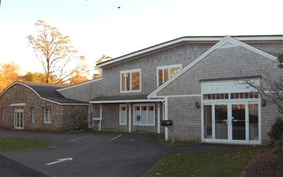
1611 Main St, West Barnstable, MA 02668

Property Detail
1611 Main St
BARN-000197-000000-000043
Barnstable
Commercialofficeresidentialmixeduse
Massachusetts
1
43
B and X Area of moderate flood hazard, usually the area between the limits of the 100-year and 500-year floods.
0.39 AC
0
Cape Cod
2025
Other Market Areas
012200
Barnstable Town, MA
13,012 SF
NEARBY LISTINGS FOR SALE OR LEASE
-
-
View all West Barnstable listings for sale on LoopNet.com
DEMOGRAPHICS near 1611 Main St
1 mile
3 mile
5 mile
2025 Total Population
547
12,370
41,117
2030 Population
515
11,815
39,974
Pop Growth 2025-2030
(5.85%)
(4.49%)
(2.78%)
Average Age
49
47
47
2025 Total Households
219
5,017
16,878
HH Growth 2025-2030
(6.39%)
(4.86%)
(3.06%)
Median Household Inc
$107,894
$110,243
$97,809
Avg Household Size
2.30
2.40
2.30
2025 Avg HH Vehicles
2.00
2.00
2.00
Median Home Value
$741,007
$635,998
$636,521
Median Year Built
1984
1980
1978
Nearby Places
Map Layers
Map Styles
 Street
 Aerial
Layers
 Traffic
 Biking
Places
Listings with unknown addresses are not visible on the map
- Restaurants
- Banks
- Shops
- Fitness
- Groceries
PUBLIC TRANSPORTATION
COMMUTER RAIL
Hyannis (CapeFLYER - Cape Cod Regional Transit Authority)
Drive
Walk
Distance
Hyannis (CapeFLYER - Cape Cod Regional Transit Authority)
10 min
4.9 mi
AIRPORT
Martha's Vineyard
Drive
Walk
Distance
Martha's Vineyard
103 min
37.5 mi
Freight Ports
Port of New Bedford Harbor
Drive
Walk
Distance
Port of New Bedford Harbor
60 min
42.5 mi
Nearby Properties
Address
Land Use
TOTAL SIZE
Lot Size
Zoning
Address
Land Use
TOTAL SIZE
Lot Size
Zoning
44 AC
RG;RF
Address
Land Use
TOTAL SIZE
Lot Size
Zoning
10.68 AC
Address
Land Use
TOTAL SIZE
Lot Size
Zoning
Address
Land Use
TOTAL SIZE
Lot Size
Zoning
17.95 AC
VB-A;R
Address
Land Use
TOTAL SIZE
Lot Size
Zoning
1,114.30 AC
Address
Land Use
TOTAL SIZE
Lot Size
Zoning
14.34 AC
B;IND
Address
Land Use
TOTAL SIZE
Lot Size
Zoning
30,000 SF
8.48 AC
HB;RF-
Address
Land Use
TOTAL SIZE
Lot Size
Zoning
253,562 SF
12.54 AC
RC-1;H
Address
Land Use
TOTAL SIZE
Lot Size
Zoning
12.82 AC
B;HB
Address
Land Use
TOTAL SIZE
Lot Size
Zoning
37,169 SF
8.71 AC
RC-1;H
Address
Land Use
TOTAL SIZE
Lot Size
Zoning
90,837 SF
11.66 AC
IN
Address
Land Use
TOTAL SIZE
Lot Size
Zoning
73,621 SF
9.91 AC
RC;HB
Address
Land Use
TOTAL SIZE
Lot Size
Zoning
54,688 SF
10.02 AC
B;RG;R
Address
Land Use
TOTAL SIZE
Lot Size
Zoning
36,536 SF
36.91 AC
RG;RF-
Address
Land Use
TOTAL SIZE
Lot Size
Zoning
27,500 SF
3.44 AC
RD-1;R
Address
Land Use
TOTAL SIZE
Lot Size
Zoning
39,689 SF
9.12 AC
Address
Land Use
TOTAL SIZE
Lot Size
Zoning
4.52 AC
RF
Address
Land Use
TOTAL SIZE
Lot Size
Zoning
126.31 AC
RG;RF-
Address
Land Use
TOTAL SIZE
Lot Size
Zoning
3.54 AC
Address
Land Use
TOTAL SIZE
Lot Size
Zoning
4.60 AC
RC;HB
Address
Land Use
TOTAL SIZE
Lot Size
Zoning
18,088 SF
3.28 AC
RD-1;H
Address
Land Use
TOTAL SIZE
Lot Size
Zoning
800 SF
7.30 AC
MB
Address
Land Use
TOTAL SIZE
Lot Size
Zoning
22,795 SF
8.27 AC
IND;RG
Address
Land Use
TOTAL SIZE
Lot Size
Zoning
1,188.31 AC
RF;RF-
Address
Land Use
TOTAL SIZE
Lot Size
Zoning
143.68 AC
R
Address
Land Use
TOTAL SIZE
Lot Size
Zoning
58,488 SF
4.35 AC
B;HB
Address
Land Use
TOTAL SIZE
Lot Size
Zoning
7.06 AC
RD-1;R
Address
Land Use
TOTAL SIZE
Lot Size
Zoning
Address
Land Use
TOTAL SIZE
Lot Size
Zoning
8.18 AC
HB;B;R
Address
Land Use
TOTAL SIZE
Lot Size
Zoning
17,159 SF
6.25 AC
RD
The World's #1 Commercial Real Estate Marketplace
Connect with us
© 2026 CoStar Group
The information above has been obtained from sources believed reliable. While we do not doubt its accuracy we have not verified it and make no guarantee, warranty or representation about it. It is your responsibility to independently confirm its accuracy and completeness. Any projections, opinions, assumptions, or estimates used are for example only and do not represent the current or future performance of the property. The value of this transaction to you depends on tax and other factors which should be evaluated by your tax, financial, and legal advisors. You and your advisors should conduct a careful, independent investigation of the property to determine to your satisfaction the suitability of the property for your needs.