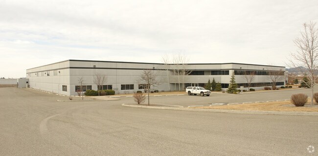
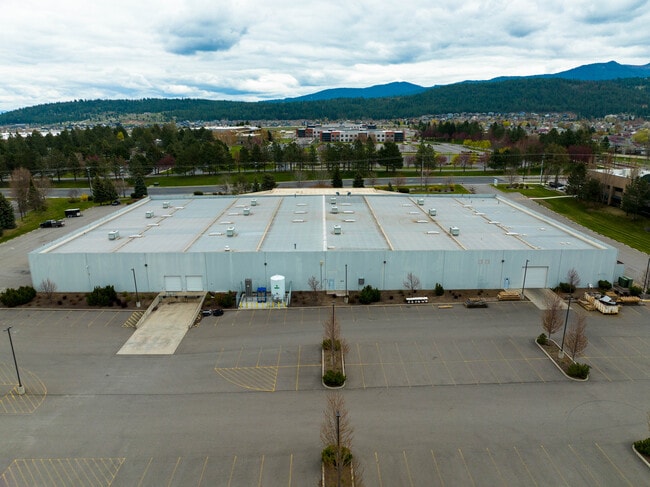
Property Record
1611 N Molter Rd, Liberty Lake, WA 99019

NEARBY LISTINGS FOR SALE OR LEASE
Property Detail
1611 N Molter Rd
55104.9178
Homestead Indust Propertie
Industrialgeneral
10-25-45 PTN OF HOMESTEAD INDUSTRIAL PROPERTIES OF BSP-1 DAF: BEG AT SW COR OF SD BSP-1 TH N 03DEG 17MIN 39SDS W 214FT TH N 87DEG 03MIN 56SDS E 648FT TO TRUE POB TH CONT N87DEG 03MIN 56SDS E 584.58FT TO W R/W MOLTER RD TH N 03DEG 17MIN 39SDS W ALG SD
X
Spokane
53063C0615D
Washington
2025
8.11 AC
2025
Valley
013203
Spokane
80,744 SF
Spokane-Spokane Valley, WA
DEMOGRAPHICS near 1611 N Molter Rd
1 Mile
3 Mile
5 Mile
2024 Total Population
7,203
26,673
55,937
2029 Population
7,677
28,504
60,583
Pop Growth 2024-2029
+ 6.58%
+ 6.86%
+ 8.31%
Average Age
41
42
40
2024 Total Households
2,722
10,359
21,802
HH Growth 2024-2029
+ 6.72%
+ 7.05%
+ 8.47%
Median Household Inc
$107,247
$92,369
$79,673
Avg Household Size
2.60
2.50
2.50
2024 Avg HH Vehicles
2.00
2.00
2.00
Median Home Value
$465,498
$441,550
$429,741
Median Year Built
1997
1995
1998
Nearby Places
Map Layers
Map Styles
 Street
 Aerial
- Restaurants
- Banks
- Shops
- Fitness
- Groceries
PUBLIC TRANSPORTATION
AIRPORT
Spokane International
DRIVE
WALK
Distance
Spokane International
32 min
22.8 mi
Freight Ports
Port of Everett
DRIVE
WALK
Distance
Port of Everett
359 min
318.4 mi
SALE & LEASE HISTORY
LISTING DATE
SALE/LEASE

May 16, 2022
For Sale
Jul 29, 2019
For Lease
Nearby Properties
Address
Land Use
TOTAL SIZE
Lot Size
Zoning
Address
Land Use
TOTAL SIZE
Lot Size
Zoning
275,534 SF
67.98 AC
P
Address
Land Use
TOTAL SIZE
Lot Size
Zoning
296,760 SF
37.61 AC
I-1
Address
Land Use
TOTAL SIZE
Lot Size
Zoning
602,024 SF
44.20 AC
I
Address
Land Use
TOTAL SIZE
Lot Size
Zoning
358,700 SF
16.41 AC
R3
Address
Land Use
TOTAL SIZE
Lot Size
Zoning
98,088 SF
13.94 AC
SAP
Address
Land Use
TOTAL SIZE
Lot Size
Zoning
153,691 SF
24.92 AC
P
Address
Land Use
TOTAL SIZE
Lot Size
Zoning
133,310 SF
10.93 AC
M2
Address
Land Use
TOTAL SIZE
Lot Size
Zoning
150,936 SF
9.30 AC
M2
Address
Land Use
TOTAL SIZE
Lot Size
Zoning
145,884 SF
6.87 AC
M2
Address
Land Use
TOTAL SIZE
Lot Size
Zoning
105,457 SF
9.69 AC
SAP
Address
Land Use
TOTAL SIZE
Lot Size
Zoning
78,795 SF
39.53 AC
C2
Address
Land Use
TOTAL SIZE
Lot Size
Zoning
3,918 SF
135.08 AC
O
Address
Land Use
TOTAL SIZE
Lot Size
Zoning
82,600 SF
9.27 AC
I
Address
Land Use
TOTAL SIZE
Lot Size
Zoning
104,962 SF
4.86 AC
Address
Land Use
TOTAL SIZE
Lot Size
Zoning
64,280 SF
5.80 AC
I
Address
Land Use
TOTAL SIZE
Lot Size
Zoning
154,265 SF
13.38 AC
I
Address
Land Use
TOTAL SIZE
Lot Size
Zoning
184,710 SF
13.12 AC
I
Address
Land Use
TOTAL SIZE
Lot Size
Zoning
202,570 SF
21.72 AC
I
Address
Land Use
TOTAL SIZE
Lot Size
Zoning
296,341 SF
23.08 AC
I
Address
Land Use
TOTAL SIZE
Lot Size
Zoning
140,395 SF
10.44 AC
I
Address
Land Use
TOTAL SIZE
Lot Size
Zoning
102,529 SF
13.98 AC
M2
Address
Land Use
TOTAL SIZE
Lot Size
Zoning
64,280 SF
7.98 AC
I
Address
Land Use
TOTAL SIZE
Lot Size
Zoning
33,288 SF
5.53 AC
Address
Land Use
TOTAL SIZE
Lot Size
Zoning
75,021 SF
3.02 AC
SAP
Address
Land Use
TOTAL SIZE
Lot Size
Zoning
9,128 SF
75.60 AC
O
Address
Land Use
TOTAL SIZE
Lot Size
Zoning
51,081 SF
3.18 AC
C1
Address
Land Use
TOTAL SIZE
Lot Size
Zoning
75,200 SF
6.18 AC
M3
Address
Land Use
TOTAL SIZE
Lot Size
Zoning
67,084 SF
1.92 AC
CMU
Address
Land Use
TOTAL SIZE
Lot Size
Zoning
32,439 SF
4.75 AC
C2
The World's #1 Commercial Real Estate Marketplace
Connect with us
© 2026 CoStar Group
The information above has been obtained from sources believed reliable. While we do not doubt its accuracy we have not verified it and make no guarantee, warranty or representation about it. It is your responsibility to independently confirm its accuracy and completeness. Any projections, opinions, assumptions, or estimates used are for example only and do not represent the current or future performance of the property. The value of this transaction to you depends on tax and other factors which should be evaluated by your tax, financial, and legal advisors. You and your advisors should conduct a careful, independent investigation of the property to determine to your satisfaction the suitability of the property for your needs.