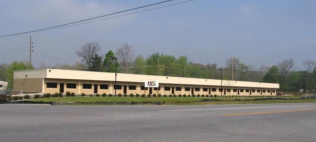
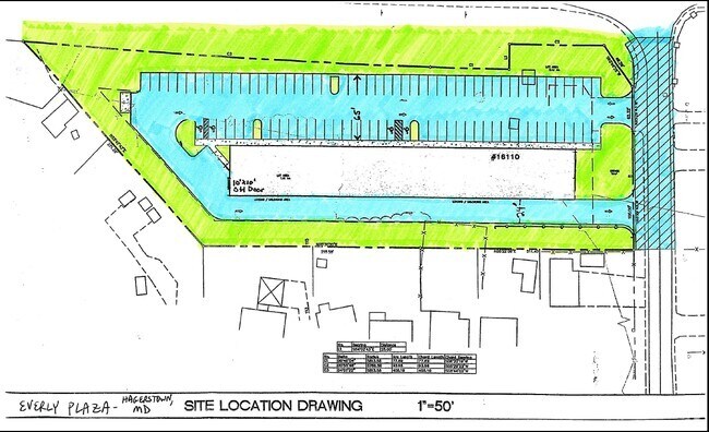
Property Record
16110 Everly Rd, Hagerstown, MD 21740

Current Lease Availabilities
Property Detail
16110 Everly Rd
02-004232
2.23 ACRES 16110 EVERLY ROAD W/S GREENCASTLE PIKE
Stripcommercialcenter
Washington
HI
Maryland
B and X Area of moderate flood hazard, usually the area between the limits of the 100-year and 500-year floods.
2.23 AC
2024
Washington County
2025
Washington, DC
010803
Hagerstown-Martinsburg, MD-WV
17,250 SF
NEARBY LISTINGS FOR SALE OR LEASE
DEMOGRAPHICS near 16110 Everly Rd
1 mile
3 mile
5 mile
2025 Total Population
304
16,819
54,725
2030 Population
305
17,171
56,286
Pop Growth 2025-2030
+ 0.33%
+ 2.09%
+ 2.85%
Average Age
45
43
41
2025 Total Households
115
6,696
21,638
HH Growth 2025-2030
0.00%
+ 2.15%
+ 2.85%
Median Household Inc
$84,051
$69,801
$66,185
Avg Household Size
2.20
2.40
2.40
2025 Avg HH Vehicles
2.00
2.00
2.00
Median Home Value
$245,714
$254,427
$251,440
Median Year Built
1971
1974
1972
Nearby Places
Map Layers
Map Styles
 Street
 Aerial
Transit
 Traffic
 Biking
Places
Listings with unknown addresses are not visible on the map
- Restaurants
- Banks
- Shops
- Fitness
- Groceries
PUBLIC TRANSPORTATION
AIRPORT
Hagerstown Regional/Richard A Henson Field
Drive
Walk
Distance
Hagerstown Regional/Richard A Henson Field
15 min
9.4 mi
Freight Ports
Port of Baltimore
Drive
Walk
Distance
Port of Baltimore
92 min
78.8 mi
Nearby Properties
Address
Land Use
TOTAL SIZE
Lot Size
Zoning
Address
Land Use
TOTAL SIZE
Lot Size
Zoning
1,006,880 SF
132.50 AC
PI
Address
Land Use
TOTAL SIZE
Lot Size
Zoning
617,025 SF
142.67 AC
IG
Address
Land Use
TOTAL SIZE
Lot Size
Zoning
825,620 SF
53.74 AC
IG
Address
Land Use
TOTAL SIZE
Lot Size
Zoning
737,000 SF
59.57 AC
PB
Address
Land Use
TOTAL SIZE
Lot Size
Zoning
730,880 SF
87.62 AC
BL
Address
Land Use
TOTAL SIZE
Lot Size
Zoning
157,680 SF
69.83 AC
HI
Address
Land Use
TOTAL SIZE
Lot Size
Zoning
591,555 SF
114.50 AC
HI
Address
Land Use
TOTAL SIZE
Lot Size
Zoning
153,846 SF
110.85 AC
U
Address
Land Use
TOTAL SIZE
Lot Size
Zoning
1,021,162 SF
117.63 AC
HI
Address
Land Use
TOTAL SIZE
Lot Size
Zoning
824,298 SF
70.25 AC
HI
Address
Land Use
TOTAL SIZE
Lot Size
Zoning
162,850 SF
65.81 AC
IG
Address
Land Use
TOTAL SIZE
Lot Size
Zoning
294,240 SF
43.79 AC
HI
Address
Land Use
TOTAL SIZE
Lot Size
Zoning
161,172 SF
19.70 AC
HI
Address
Land Use
TOTAL SIZE
Lot Size
Zoning
506,003 SF
40 AC
HI
Address
Land Use
TOTAL SIZE
Lot Size
Zoning
113,466 SF
10.62 AC
IG
Address
Land Use
TOTAL SIZE
Lot Size
Zoning
91,026 SF
20.28 AC
A
Address
Land Use
TOTAL SIZE
Lot Size
Zoning
622,245 SF
52.90 AC
U
Address
Land Use
TOTAL SIZE
Lot Size
Zoning
486,861 SF
35.40 AC
HI
Address
Land Use
TOTAL SIZE
Lot Size
Zoning
231,293 SF
16.93 AC
PI
Address
Land Use
TOTAL SIZE
Lot Size
Zoning
88,042 SF
9.98 AC
RT
Address
Land Use
TOTAL SIZE
Lot Size
Zoning
36,000 SF
23.49 AC
HI
Address
Land Use
TOTAL SIZE
Lot Size
Zoning
9,918 SF
17 AC
IG
Address
Land Use
TOTAL SIZE
Lot Size
Zoning
5,427 SF
20.49 AC
BG
Address
Land Use
TOTAL SIZE
Lot Size
Zoning
2,324 SF
6 AC
TR
Address
Land Use
TOTAL SIZE
Lot Size
Zoning
924 SF
67.86 AC
RU
Address
Land Use
TOTAL SIZE
Lot Size
Zoning
58,065 SF
15.42 AC
BG
Address
Land Use
TOTAL SIZE
Lot Size
Zoning
65,634 SF
10.23 AC
CR
Address
Land Use
TOTAL SIZE
Lot Size
Zoning
7,943 SF
26.33 AC
HI
Address
Land Use
TOTAL SIZE
Lot Size
Zoning
110,387 SF
10.51 AC
PB
Address
Land Use
TOTAL SIZE
Lot Size
Zoning
110,000 SF
27.85 AC
IG
The World's #1 Commercial Real Estate Marketplace
Connect with us
© 2026 CoStar Group
The information above has been obtained from sources believed reliable. While we do not doubt its accuracy we have not verified it and make no guarantee, warranty or representation about it. It is your responsibility to independently confirm its accuracy and completeness. Any projections, opinions, assumptions, or estimates used are for example only and do not represent the current or future performance of the property. The value of this transaction to you depends on tax and other factors which should be evaluated by your tax, financial, and legal advisors. You and your advisors should conduct a careful, independent investigation of the property to determine to your satisfaction the suitability of the property for your needs.