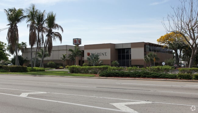
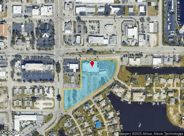
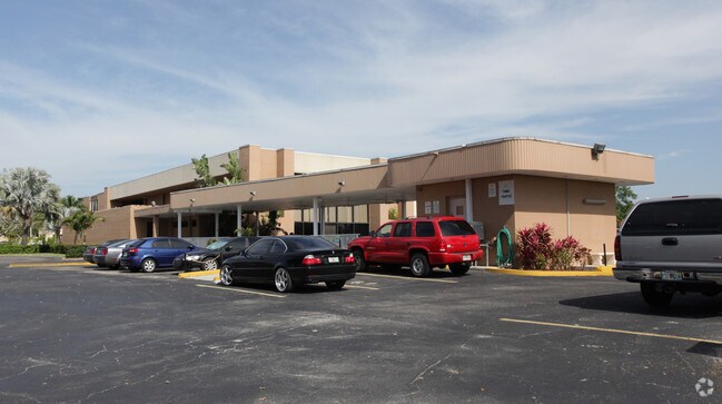
Property Record
1612 Cape Coral Pky E, Cape Coral, FL 33904

NEARBY LISTINGS FOR SALE OR LEASE
Property Detail
1612 Cape Coral Pky E
Cape Coral-Fort Myers, FL
Cape Coral
18-45-24-C2-00440.0030
CAPE CORAL UNIT 6 PART 6 BLK 440 PB 16/136 LOTS 3 + 4 + PT 5 VAC OR 562 PG 645 + LOT 5 DESC OR 2132 PG 2541
Officebuilding
Lee
AE
Florida
12071C0412G
3,4,5
2024
4.27 AC
2025
Cape Coral
010802
Southwest Florida
39,946 SF
DEMOGRAPHICS near 1612 Cape Coral Pky E
1 Mile
3 Mile
5 Mile
2024 Total Population
6,464
62,616
186,561
2029 Population
7,773
74,459
221,423
Pop Growth 2024-2029
+ 20.25%
+ 18.91%
+ 18.69%
Average Age
53
51
49
2024 Total Households
3,420
29,728
84,815
HH Growth 2024-2029
+ 19.88%
+ 18.59%
+ 18.40%
Median Household Inc
$53,614
$62,414
$61,733
Avg Household Size
1.90
2.00
2.10
2024 Avg HH Vehicles
2.00
2.00
2.00
Median Home Value
$319,817
$309,323
$288,102
Median Year Built
1980
1985
1988
Nearby Places
- Restaurants
- Banks
- Shops
- Fitness
- Groceries
PUBLIC TRANSPORTATION
AIRPORT
Southwest Florida International
DRIVE
WALK
Distance
Southwest Florida International
25 min
13.3 mi
Punta Gorda
DRIVE
WALK
Distance
Punta Gorda
48 min
29.7 mi
SALE & LEASE HISTORY
LISTING DATE
SALE/LEASE

Jun 08, 2020
For Sale
Nearby Properties
Address
Land Use
TOTAL SIZE
Lot Size
Zoning
Address
Land Use
TOTAL SIZE
Lot Size
Zoning
539,207 SF
61.09 AC
AG-2
Address
Land Use
TOTAL SIZE
Lot Size
Zoning
446,205 SF
28.90 AC
CC
Address
Land Use
TOTAL SIZE
Lot Size
Zoning
423,044 SF
37.11 AC
C-1
Address
Land Use
TOTAL SIZE
Lot Size
Zoning
381,135 SF
15.07 AC
MPD
Address
Land Use
TOTAL SIZE
Lot Size
Zoning
1,446 SF
9.81 AC
RS-6
Address
Land Use
TOTAL SIZE
Lot Size
Zoning
261,136 SF
11.68 AC
AG-2
Address
Land Use
TOTAL SIZE
Lot Size
Zoning
153,907 SF
22.03 AC
TFC2
Address
Land Use
TOTAL SIZE
Lot Size
Zoning
211,588 SF
14.89 AC
MPD
Address
Land Use
TOTAL SIZE
Lot Size
Zoning
144,607 SF
20 AC
INS
Address
Land Use
TOTAL SIZE
Lot Size
Zoning
54,248 SF
15.42 AC
C1-W
Address
Land Use
TOTAL SIZE
Lot Size
Zoning
99,749 SF
11.49 AC
WSHP
Address
Land Use
TOTAL SIZE
Lot Size
Zoning
469,746 SF
89.45 AC
RPD
Address
Land Use
TOTAL SIZE
Lot Size
Zoning
66,486 SF
0.56 AC
C-1A
Address
Land Use
TOTAL SIZE
Lot Size
Zoning
113,239 SF
12.62 AC
R1-D
Address
Land Use
TOTAL SIZE
Lot Size
Zoning
26,337 SF
11.54 AC
C-1
Address
Land Use
TOTAL SIZE
Lot Size
Zoning
47,660 SF
3.52 AC
C1-D
Address
Land Use
TOTAL SIZE
Lot Size
Zoning
98,980 SF
8.93 AC
CPD
Address
Land Use
TOTAL SIZE
Lot Size
Zoning
6,910 SF
7.37 AC
AG-2
Address
Land Use
TOTAL SIZE
Lot Size
Zoning
121,182 SF
9.91 AC
C-1A
Address
Land Use
TOTAL SIZE
Lot Size
Zoning
52,003 SF
6.66 AC
WSHP
Address
Land Use
TOTAL SIZE
Lot Size
Zoning
69,261 SF
8.44 AC
WSHP
Address
Land Use
TOTAL SIZE
Lot Size
Zoning
81,988 SF
7.97 AC
C-1A
Address
Land Use
TOTAL SIZE
Lot Size
Zoning
87,627 SF
8.75 AC
C-1A
Address
Land Use
TOTAL SIZE
Lot Size
Zoning
74,368 SF
2.32 AC
SC
Address
Land Use
TOTAL SIZE
Lot Size
Zoning
65,875 SF
7.67 AC
MPD
Address
Land Use
TOTAL SIZE
Lot Size
Zoning
86,497 SF
6.20 AC
SC
Address
Land Use
TOTAL SIZE
Lot Size
Zoning
45,809 SF
1.75 AC
SC
Address
Land Use
TOTAL SIZE
Lot Size
Zoning
77,465 SF
5.39 AC
CPD
Address
Land Use
TOTAL SIZE
Lot Size
Zoning
82,526 SF
113.48 AC
PUD
Address
Land Use
TOTAL SIZE
Lot Size
Zoning
67,396 SF
2.02 AC
SC
The World's #1 Commercial Real Estate Marketplace
Connect with us
© 2025 CoStar Group
The information above has been obtained from sources believed reliable. While we do not doubt its accuracy we have not verified it and make no guarantee, warranty or representation about it. It is your responsibility to independently confirm its accuracy and completeness. Any projections, opinions, assumptions, or estimates used are for example only and do not represent the current or future performance of the property. The value of this transaction to you depends on tax and other factors which should be evaluated by your tax, financial, and legal advisors. You and your advisors should conduct a careful, independent investigation of the property to determine to your satisfaction the suitability of the property for your needs.