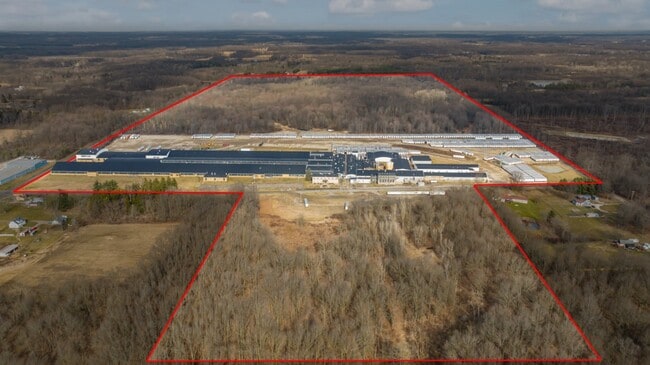
Property Record
16123 Armour St Ne, Alliance, OH 44601


Current Lease Availabilities
NEARBY LISTINGS FOR SALE OR LEASE
Property Detail
16123 Armour St Ne
10012302
13SE 32.63A (SEE ALSO 10012304) (63.74A)
Lightindustrial
Stark
X
Ohio
39029C0025E
32.63 AC
0
Stark County
2025
Cleveland
710800
Canton-Massillon, OH
404,942 SF
DEMOGRAPHICS near 16123 Armour St Ne
1 Mile
3 Mile
5 Mile
2024 Total Population
642
19,020
37,354
2029 Population
640
19,058
37,250
Pop Growth 2024-2029
(0.31%)
+ 0.20%
(0.28%)
Average Age
43
38
42
2024 Total Households
250
7,184
15,305
HH Growth 2024-2029
(0.40%)
+ 0.28%
(0.24%)
Median Household Inc
$108,333
$43,208
$50,769
Avg Household Size
2.60
2.40
2.30
2024 Avg HH Vehicles
2.00
2.00
2.00
Median Home Value
$138,235
$84,259
$122,916
Median Year Built
1949
1948
1954
Nearby Places
Map Layers
Map Styles
 Street
 Aerial
- Restaurants
- Banks
- Shops
- Fitness
- Groceries
PUBLIC TRANSPORTATION
COMMUTER RAIL
Alliance Amtrak (Capitol Limited - Amtrak)
DRIVE
WALK
Distance
Alliance Amtrak (Capitol Limited - Amtrak)
4 min
1.9 mi
AIRPORT
Akron-Canton Regional
DRIVE
WALK
Distance
Akron-Canton Regional
33 min
21.5 mi
Freight Ports
Port of Toledo
DRIVE
WALK
Distance
Port of Toledo
191 min
158.1 mi
Nearby Properties
Address
Land Use
TOTAL SIZE
Lot Size
Zoning
Address
Land Use
TOTAL SIZE
Lot Size
Zoning
275,422 SF
10 AC
Address
Land Use
TOTAL SIZE
Lot Size
Zoning
402,113 SF
25.10 AC
Address
Land Use
TOTAL SIZE
Lot Size
Zoning
79,700 SF
1.80 AC
Address
Land Use
TOTAL SIZE
Lot Size
Zoning
60,037 SF
6.38 AC
Address
Land Use
TOTAL SIZE
Lot Size
Zoning
65,108 SF
164.87 AC
Address
Land Use
TOTAL SIZE
Lot Size
Zoning
73,853 SF
3.83 AC
Address
Land Use
TOTAL SIZE
Lot Size
Zoning
75,318 SF
4.59 AC
Address
Land Use
TOTAL SIZE
Lot Size
Zoning
73,764 SF
1.52 AC
Address
Land Use
TOTAL SIZE
Lot Size
Zoning
62,767 SF
2.85 AC
Address
Land Use
TOTAL SIZE
Lot Size
Zoning
53,959 SF
3.58 AC
Address
Land Use
TOTAL SIZE
Lot Size
Zoning
10,800 SF
6.60 AC
Address
Land Use
TOTAL SIZE
Lot Size
Zoning
56,474 SF
9.80 AC
Address
Land Use
TOTAL SIZE
Lot Size
Zoning
80,552 SF
68.27 AC
Address
Land Use
TOTAL SIZE
Lot Size
Zoning
29,283 SF
1.53 AC
Address
Land Use
TOTAL SIZE
Lot Size
Zoning
154,537 SF
14.37 AC
Address
Land Use
TOTAL SIZE
Lot Size
Zoning
90,156 SF
8.20 AC
Address
Land Use
TOTAL SIZE
Lot Size
Zoning
626,234 SF
25.15 AC
Address
Land Use
TOTAL SIZE
Lot Size
Zoning
135,928 SF
6.62 AC
Address
Land Use
TOTAL SIZE
Lot Size
Zoning
119,046 SF
14.35 AC
Address
Land Use
TOTAL SIZE
Lot Size
Zoning
79,068 SF
1.91 AC
Address
Land Use
TOTAL SIZE
Lot Size
Zoning
54,898 SF
25 AC
Address
Land Use
TOTAL SIZE
Lot Size
Zoning
26.28 AC
Address
Land Use
TOTAL SIZE
Lot Size
Zoning
24,624 SF
3.99 AC
Address
Land Use
TOTAL SIZE
Lot Size
Zoning
33,494 SF
3.20 AC
Address
Land Use
TOTAL SIZE
Lot Size
Zoning
21,317 SF
0.38 AC
Address
Land Use
TOTAL SIZE
Lot Size
Zoning
53,356 SF
6.60 AC
Address
Land Use
TOTAL SIZE
Lot Size
Zoning
83,046 SF
15.51 AC
Address
Land Use
TOTAL SIZE
Lot Size
Zoning
512,085 SF
28.67 AC
Address
Land Use
TOTAL SIZE
Lot Size
Zoning
32,686 SF
0.40 AC
The World's #1 Commercial Real Estate Marketplace
Connect with us
© 2025 CoStar Group
The information above has been obtained from sources believed reliable. While we do not doubt its accuracy we have not verified it and make no guarantee, warranty or representation about it. It is your responsibility to independently confirm its accuracy and completeness. Any projections, opinions, assumptions, or estimates used are for example only and do not represent the current or future performance of the property. The value of this transaction to you depends on tax and other factors which should be evaluated by your tax, financial, and legal advisors. You and your advisors should conduct a careful, independent investigation of the property to determine to your satisfaction the suitability of the property for your needs.