Property Record
16126 Old Columbia Pike, Burtonsville, MD 20866
NEARBY LISTINGS FOR SALE OR LEASE
-
-
View all Burtonsville listings for sale on LoopNet.com
Property Detail
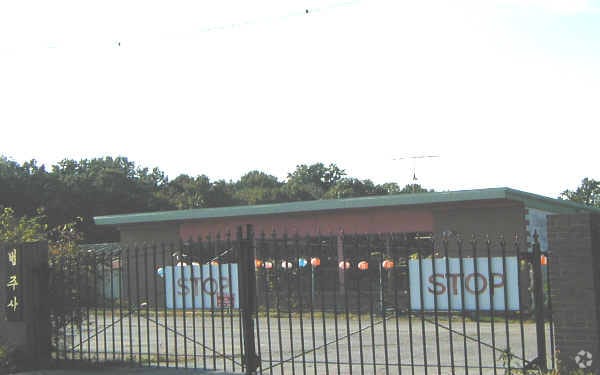
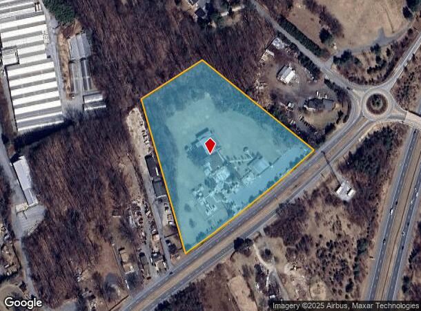
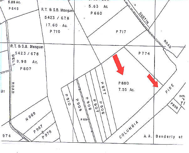
16126 Old Columbia Pike
05-00250055
Bealls Manor
Religious
WATERS GIFT
X
Montgomery
24033C0035E
Maryland
2024
7.55 AC
2025
North Silver Spring/Rt 29
701408
Washington, DC
7,000 SF
Washington-Arlington-Alexandria, DC-VA-MD-WV
DEMOGRAPHICS near 16126 Old Columbia Pike
1 Mile
3 Mile
5 Mile
2024 Total Population
493
45,886
168,068
2029 Population
484
45,510
167,448
Pop Growth 2024-2029
(1.83%)
(0.82%)
(0.37%)
Average Age
42
39
40
2024 Total Households
152
15,417
59,488
HH Growth 2024-2029
(1.97%)
(0.99%)
(0.47%)
Median Household Inc
$119,564
$127,340
$111,975
Avg Household Size
3.10
2.90
2.70
2024 Avg HH Vehicles
3.00
2.00
2.00
Median Home Value
$615,384
$558,283
$484,284
Median Year Built
1981
1984
1985
Nearby Places
Map Layers
Map Styles
 Street
 Aerial
- Restaurants
- Banks
- Shops
- Fitness
- Groceries
PUBLIC TRANSPORTATION
COMMUTER RAIL
Laurel (CAMDEN - WASHINGTON - Maryland Area Regional Commuter Trains (The MARC), Camden Line - Maryland Area Regional Commuter Trains (The MARC))
DRIVE
WALK
Distance
Laurel (CAMDEN - WASHINGTON - Maryland Area Regional Commuter Trains (The MARC), Camden Line - Maryland Area Regional Commuter Trains (The MARC))
13 min
6.5 mi
Muirkirk (CAMDEN - WASHINGTON - Maryland Area Regional Commuter Trains (The MARC), Camden Line - Maryland Area Regional Commuter Trains (The MARC))
DRIVE
WALK
Distance
Muirkirk (CAMDEN - WASHINGTON - Maryland Area Regional Commuter Trains (The MARC), Camden Line - Maryland Area Regional Commuter Trains (The MARC))
12 min
7.8 mi
AIRPORT
Baltimore/Washington International Thurgood Marshall
DRIVE
WALK
Distance
Baltimore/Washington International Thurgood Marshall
31 min
21.8 mi
Ronald Reagan Washington Ntl
DRIVE
WALK
Distance
Ronald Reagan Washington Ntl
38 min
22.5 mi
Freight Ports
Port of Baltimore
DRIVE
WALK
Distance
Port of Baltimore
35 min
24.6 mi
Nearby Properties
Address
Land Use
TOTAL SIZE
Lot Size
Zoning
Address
Land Use
TOTAL SIZE
Lot Size
Zoning
531,312 SF
25.70 AC
R30
Address
Land Use
TOTAL SIZE
Lot Size
Zoning
89,320 SF
101.22 AC
RRMXD
Address
Land Use
TOTAL SIZE
Lot Size
Zoning
559,944 SF
11.89 AC
IE
Address
Land Use
TOTAL SIZE
Lot Size
Zoning
453,692 SF
6.83 AC
R-APT
Address
Land Use
TOTAL SIZE
Lot Size
Zoning
166,410 SF
26.25 AC
CRT1.
Address
Land Use
TOTAL SIZE
Lot Size
Zoning
310,052 SF
9.63 AC
R20
Address
Land Use
TOTAL SIZE
Lot Size
Zoning
235,616 SF
12.81 AC
R30
Address
Land Use
TOTAL SIZE
Lot Size
Zoning
4,380 SF
17.89 AC
CRT22
Address
Land Use
TOTAL SIZE
Lot Size
Zoning
456,896 SF
8.96 AC
R20
Address
Land Use
TOTAL SIZE
Lot Size
Zoning
239,072 SF
10.41 AC
R20
Address
Land Use
TOTAL SIZE
Lot Size
Zoning
362,438 SF
39.95 AC
IE
Address
Land Use
TOTAL SIZE
Lot Size
Zoning
154,775 SF
33.38 AC
R200
Address
Land Use
TOTAL SIZE
Lot Size
Zoning
195,369 SF
9.72 AC
R20
Address
Land Use
TOTAL SIZE
Lot Size
Zoning
19.17 AC
IE
Address
Land Use
TOTAL SIZE
Lot Size
Zoning
102,264 SF
5.73 AC
MXD 3
Address
Land Use
TOTAL SIZE
Lot Size
Zoning
139,421 SF
6 AC
MXD3
Address
Land Use
TOTAL SIZE
Lot Size
Zoning
115,000 SF
10.14 AC
RE1
Address
Land Use
TOTAL SIZE
Lot Size
Zoning
141,492 SF
7.96 AC
R20
Address
Land Use
TOTAL SIZE
Lot Size
Zoning
127,803 SF
2.91 AC
EOF07
Address
Land Use
TOTAL SIZE
Lot Size
Zoning
89,612 SF
30.76 AC
RRDEO
Address
Land Use
TOTAL SIZE
Lot Size
Zoning
94,545 SF
30.85 AC
RC
Address
Land Use
TOTAL SIZE
Lot Size
Zoning
92,227 SF
6.51 AC
R200
Address
Land Use
TOTAL SIZE
Lot Size
Zoning
75,000 SF
2.83 AC
RRMXD
Address
Land Use
TOTAL SIZE
Lot Size
Zoning
104,796 SF
3.49 AC
MXD3
Address
Land Use
TOTAL SIZE
Lot Size
Zoning
95,600 SF
3.91 AC
IM2.5
Address
Land Use
TOTAL SIZE
Lot Size
Zoning
150,020 SF
19.11 AC
IE
Address
Land Use
TOTAL SIZE
Lot Size
Zoning
117,780 SF
4.84 AC
MXD3
Address
Land Use
TOTAL SIZE
Lot Size
Zoning
93,772 SF
4.35 AC
MXD3
Address
Land Use
TOTAL SIZE
Lot Size
Zoning
43,550 SF
10.17 AC
B2
Address
Land Use
TOTAL SIZE
Lot Size
Zoning
115,420 SF
4.68 AC
MXD3
The World's #1 Commercial Real Estate Marketplace
Connect with us
© 2025 CoStar Group
The information above has been obtained from sources believed reliable. While we do not doubt its accuracy we have not verified it and make no guarantee, warranty or representation about it. It is your responsibility to independently confirm its accuracy and completeness. Any projections, opinions, assumptions, or estimates used are for example only and do not represent the current or future performance of the property. The value of this transaction to you depends on tax and other factors which should be evaluated by your tax, financial, and legal advisors. You and your advisors should conduct a careful, independent investigation of the property to determine to your satisfaction the suitability of the property for your needs.