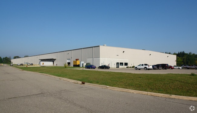
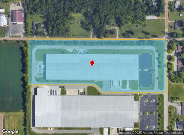
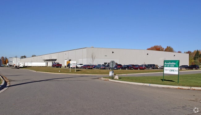
Property Record
16130 Grove Rd, Lansing, MI 48906
NEARBY LISTINGS FOR SALE OR LEASE
Property Detail
16130 Grove Rd
Lansing-East Lansing, MI
Watertown
150-035-100-005-05
THAT PART OF W 1/2 OF NE 1/4, SEC. 35 T5N R3W LYING N OF US-16; ALSO THAT PARTOF THE W 1/2 OF THE SE 1/4 OF SEC 35, LYING N
Warehouse
Clinton
X
Michigan
26065C0015D
27d-57d
2024
14.33 AC
2025
Outlying Clinton County
010300
West Michigan
210,000 SF
DEMOGRAPHICS near 16130 Grove Rd
1 Mile
3 Mile
5 Mile
2024 Total Population
316
19,502
78,417
2029 Population
323
19,467
78,795
Pop Growth 2024-2029
+ 2.22%
(0.18%)
+ 0.48%
Average Age
40
42
40
2024 Total Households
123
8,162
33,721
HH Growth 2024-2029
+ 2.44%
(0.27%)
+ 0.39%
Median Household Inc
$92,091
$80,075
$64,756
Avg Household Size
2.60
2.30
2.30
2024 Avg HH Vehicles
2.00
2.00
2.00
Median Home Value
$254,999
$201,868
$179,666
Median Year Built
1972
1972
1970
Nearby Places
Map Layers
Map Styles
 Street
 Aerial
- Restaurants
- Banks
- Shops
- Fitness
- Groceries
PUBLIC TRANSPORTATION
AIRPORT
Capital Region International
DRIVE
WALK
Distance
Capital Region International
8 min
3.1 mi
Nearby Properties
Address
Land Use
TOTAL SIZE
Lot Size
Zoning
Address
Land Use
TOTAL SIZE
Lot Size
Zoning
4,312 SF
30.47 AC
M3
Address
Land Use
TOTAL SIZE
Lot Size
Zoning
10,440 SF
18.30 AC
LI
Address
Land Use
TOTAL SIZE
Lot Size
Zoning
73,485 SF
7.86 AC
LI
Address
Land Use
TOTAL SIZE
Lot Size
Zoning
3,252 SF
10.16 AC
M3
Address
Land Use
TOTAL SIZE
Lot Size
Zoning
218,000 SF
15.60 AC
LI
Address
Land Use
TOTAL SIZE
Lot Size
Zoning
189,878 SF
27.62 AC
NONE
Address
Land Use
TOTAL SIZE
Lot Size
Zoning
125,060 SF
36.10 AC
LI
Address
Land Use
TOTAL SIZE
Lot Size
Zoning
215,785 SF
14 AC
NONE
Address
Land Use
TOTAL SIZE
Lot Size
Zoning
6,090 SF
12.96 AC
A RESID
Address
Land Use
TOTAL SIZE
Lot Size
Zoning
149,456 SF
14.49 AC
NONE
Address
Land Use
TOTAL SIZE
Lot Size
Zoning
142,400 SF
16.75 AC
LI
Address
Land Use
TOTAL SIZE
Lot Size
Zoning
558,999 SF
41.65 AC
NONE
Address
Land Use
TOTAL SIZE
Lot Size
Zoning
149,770 SF
10.33 AC
NONE
Address
Land Use
TOTAL SIZE
Lot Size
Zoning
13,593 SF
20.95 AC
B-2
Address
Land Use
TOTAL SIZE
Lot Size
Zoning
48,750 SF
24.53 AC
LI
Address
Land Use
TOTAL SIZE
Lot Size
Zoning
1,933 SF
7.01 AC
MIXED Z
Address
Land Use
TOTAL SIZE
Lot Size
Zoning
576 SF
26.90 AC
H LT IN
Address
Land Use
TOTAL SIZE
Lot Size
Zoning
72,060 SF
41 AC
B-2
Address
Land Use
TOTAL SIZE
Lot Size
Zoning
15,141 SF
16.20 AC
B-2
Address
Land Use
TOTAL SIZE
Lot Size
Zoning
87,346 SF
10.29 AC
NONE
Address
Land Use
TOTAL SIZE
Lot Size
Zoning
43,288 SF
149.50 AC
B-2
Address
Land Use
TOTAL SIZE
Lot Size
Zoning
76,674 SF
10.23 AC
NONE
Address
Land Use
TOTAL SIZE
Lot Size
Zoning
44,412 SF
14.48 AC
LI
Address
Land Use
TOTAL SIZE
Lot Size
Zoning
76,704 SF
3.42 AC
J & H
Address
Land Use
TOTAL SIZE
Lot Size
Zoning
115,349 SF
24.03 AC
NONE
Address
Land Use
TOTAL SIZE
Lot Size
Zoning
104,509 SF
10.20 AC
NONE
Address
Land Use
TOTAL SIZE
Lot Size
Zoning
37,954 SF
3.59 AC
H LT IN
Address
Land Use
TOTAL SIZE
Lot Size
Zoning
15,875 SF
Address
Land Use
TOTAL SIZE
Lot Size
Zoning
1,672 SF
4.15 AC
NONE
The World's #1 Commercial Real Estate Marketplace
Connect with us
© 2026 CoStar Group
The information above has been obtained from sources believed reliable. While we do not doubt its accuracy we have not verified it and make no guarantee, warranty or representation about it. It is your responsibility to independently confirm its accuracy and completeness. Any projections, opinions, assumptions, or estimates used are for example only and do not represent the current or future performance of the property. The value of this transaction to you depends on tax and other factors which should be evaluated by your tax, financial, and legal advisors. You and your advisors should conduct a careful, independent investigation of the property to determine to your satisfaction the suitability of the property for your needs.