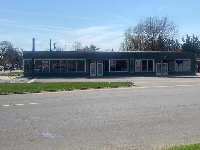
Property Record
16120 Moross Rd, Detroit, MI 48205


Current Lease Availabilities
NEARBY LISTINGS FOR SALE OR LEASE
Property Detail
16120 Moross Rd
21-05722-932
Dalbys East Pointe
Storebuilding
W KELLY RD 236 THRU 240 EXC MOROSS RD AS OP & WD DALBYS EAST POINTE SUB L50 P77 PLATS, W C R 21/819 20 IRREG
X
Wayne
26163C0140F
Michigan
2025
0.13 AC
2025
Detroit E of Woodward
500600
Detroit
4,650 SF
Detroit-Warren-Dearborn, MI
DEMOGRAPHICS near 16120 Moross Rd
1 Mile
3 Mile
5 Mile
2024 Total Population
24,416
175,366
348,468
2029 Population
24,410
175,141
346,813
Pop Growth 2024-2029
(0.02%)
(0.13%)
(0.47%)
Average Age
34
37
39
2024 Total Households
8,289
64,563
135,172
HH Growth 2024-2029
(0.12%)
(0.30%)
(0.58%)
Median Household Inc
$44,499
$44,579
$49,394
Avg Household Size
2.90
2.60
2.50
2024 Avg HH Vehicles
1.00
1.00
1.00
Median Home Value
$69,277
$92,471
$126,498
Median Year Built
1950
1952
1953
Nearby Places
Map Layers
Map Styles
 Street
 Aerial
- Restaurants
- Banks
- Shops
- Fitness
- Groceries
PUBLIC TRANSPORTATION
AIRPORT
Windsor International
DRIVE
WALK
Distance
Windsor International
42 min
21.7 mi
Detroit Metro Wayne County
DRIVE
WALK
Distance
Detroit Metro Wayne County
46 min
31.2 mi
Nearby Properties
Address
Land Use
TOTAL SIZE
Lot Size
Zoning
Address
Land Use
TOTAL SIZE
Lot Size
Zoning
1,034,990 SF
28.60 AC
Address
Land Use
TOTAL SIZE
Lot Size
Zoning
575,081 SF
8.53 AC
R6
Address
Land Use
TOTAL SIZE
Lot Size
Zoning
182,866 SF
5.08 AC
PD
Address
Land Use
TOTAL SIZE
Lot Size
Zoning
101,733 SF
1.10 AC
C-2
Address
Land Use
TOTAL SIZE
Lot Size
Zoning
166,064 SF
6.33 AC
M-3
Address
Land Use
TOTAL SIZE
Lot Size
Zoning
105,354 SF
2.33 AC
B-3
Address
Land Use
TOTAL SIZE
Lot Size
Zoning
75,284 SF
0.87 AC
C
Address
Land Use
TOTAL SIZE
Lot Size
Zoning
136,270 SF
3.42 AC
LI
Address
Land Use
TOTAL SIZE
Lot Size
Zoning
156,352 SF
2.72 AC
B-3
Address
Land Use
TOTAL SIZE
Lot Size
Zoning
26,068 SF
5.57 AC
B-2
Address
Land Use
TOTAL SIZE
Lot Size
Zoning
30,919 SF
0.86 AC
C
Address
Land Use
TOTAL SIZE
Lot Size
Zoning
36,417 SF
0.68 AC
B4
Address
Land Use
TOTAL SIZE
Lot Size
Zoning
141,023 SF
7.96 AC
MZ
Address
Land Use
TOTAL SIZE
Lot Size
Zoning
130,276 SF
6.24 AC
M-2
Address
Land Use
TOTAL SIZE
Lot Size
Zoning
92,903 SF
1.70 AC
LI
Address
Land Use
TOTAL SIZE
Lot Size
Zoning
80,320 SF
4.73 AC
RM-1
Address
Land Use
TOTAL SIZE
Lot Size
Zoning
147,581 SF
9.21 AC
MZ
Address
Land Use
TOTAL SIZE
Lot Size
Zoning
233,876 SF
8.20 AC
Address
Land Use
TOTAL SIZE
Lot Size
Zoning
36,191 SF
3.87 AC
B-2
Address
Land Use
TOTAL SIZE
Lot Size
Zoning
89,120 SF
10.75 AC
M-3
Address
Land Use
TOTAL SIZE
Lot Size
Zoning
87,897 SF
4.50 AC
RM-1
Address
Land Use
TOTAL SIZE
Lot Size
Zoning
49,807 SF
0.84 AC
PD
Address
Land Use
TOTAL SIZE
Lot Size
Zoning
122,548 SF
6.15 AC
M-2
Address
Land Use
TOTAL SIZE
Lot Size
Zoning
10,908 SF
2.78 AC
B-3
Address
Land Use
TOTAL SIZE
Lot Size
Zoning
27,860 SF
3.79 AC
LI
Address
Land Use
TOTAL SIZE
Lot Size
Zoning
109,016 SF
7.96 AC
MZ
Address
Land Use
TOTAL SIZE
Lot Size
Zoning
92,610 SF
1.76 AC
B-3
Address
Land Use
TOTAL SIZE
Lot Size
Zoning
36,086 SF
2.05 AC
B2
Address
Land Use
TOTAL SIZE
Lot Size
Zoning
107,177 SF
4.46 AC
M-3
Address
Land Use
TOTAL SIZE
Lot Size
Zoning
156,800 SF
7.87 AC
M-3
The World's #1 Commercial Real Estate Marketplace
Connect with us
© 2026 CoStar Group
The information above has been obtained from sources believed reliable. While we do not doubt its accuracy we have not verified it and make no guarantee, warranty or representation about it. It is your responsibility to independently confirm its accuracy and completeness. Any projections, opinions, assumptions, or estimates used are for example only and do not represent the current or future performance of the property. The value of this transaction to you depends on tax and other factors which should be evaluated by your tax, financial, and legal advisors. You and your advisors should conduct a careful, independent investigation of the property to determine to your satisfaction the suitability of the property for your needs.