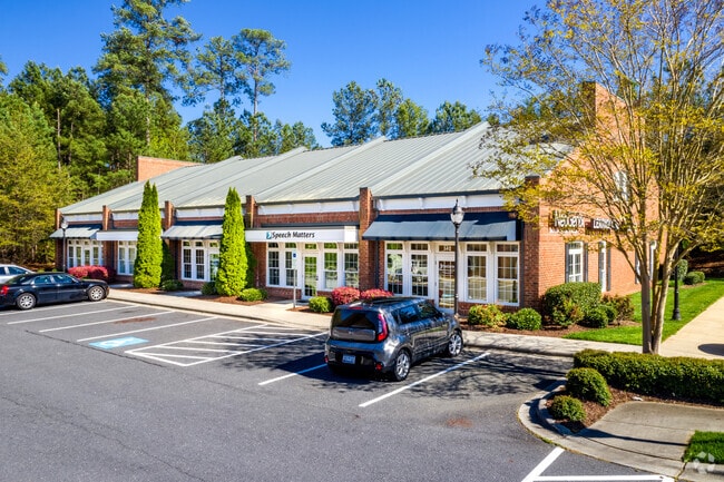
Property Record
16147 Lancaster Hwy, Charlotte, NC 28277

NEARBY LISTINGS FOR SALE OR LEASE
Property Detail
16147 Lancaster Hwy
Charlotte-Concord-Gastonia, NC-SC
Arey/Hunters Xing Iv Prcl 4
223-531-30
BLDG 2 UNIT A U/F 796-1
Commercialcondominium
Mecklenburg
X
North Carolina
45057C0040E
98
0
0.57 AC
2025
South/485
005858
Charlotte
1,476 SF
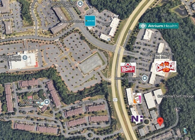
DEMOGRAPHICS near 16147 Lancaster Hwy
1 Mile
3 Mile
5 Mile
2024 Total Population
12,936
70,806
158,649
2029 Population
13,758
77,301
173,267
Pop Growth 2024-2029
+ 6.35%
+ 9.17%
+ 9.21%
Average Age
36
38
39
2024 Total Households
4,841
26,470
60,204
HH Growth 2024-2029
+ 6.28%
+ 9.13%
+ 9.10%
Median Household Inc
$123,995
$121,514
$110,834
Avg Household Size
2.60
2.70
2.60
2024 Avg HH Vehicles
2.00
2.00
2.00
Median Home Value
$444,912
$414,489
$420,068
Median Year Built
2007
2003
2001
Nearby Places
Map Layers
Map Styles
 Street
 Aerial
- Restaurants
- Banks
- Shops
- Fitness
- Groceries
PUBLIC TRANSPORTATION
AIRPORT
Charlotte/Douglas International
DRIVE
WALK
Distance
Charlotte/Douglas International
28 min
16.4 mi
Concord-Padgett Regional
DRIVE
WALK
Distance
Concord-Padgett Regional
47 min
37.7 mi
SALE & LEASE HISTORY
LISTING DATE
SALE/LEASE

May 22, 2019
For Lease
Feb 16, 2018
For Sale
Aug 23, 2019
For Lease
Nearby Properties
Address
Land Use
TOTAL SIZE
Lot Size
Zoning
Address
Land Use
TOTAL SIZE
Lot Size
Zoning
720,470 SF
5.45 AC
Address
Land Use
TOTAL SIZE
Lot Size
Zoning
425,591 SF
31.58 AC
MX1
Address
Land Use
TOTAL SIZE
Lot Size
Zoning
361,910 SF
3.60 AC
Address
Land Use
TOTAL SIZE
Lot Size
Zoning
465,462 SF
23.76 AC
CC
Address
Land Use
TOTAL SIZE
Lot Size
Zoning
539,429 SF
5.37 AC
Address
Land Use
TOTAL SIZE
Lot Size
Zoning
480,041 SF
4.76 AC
Address
Land Use
TOTAL SIZE
Lot Size
Zoning
294,279 SF
27.77 AC
R12MFCD
Address
Land Use
TOTAL SIZE
Lot Size
Zoning
215,600 SF
6.97 AC
R3
Address
Land Use
TOTAL SIZE
Lot Size
Zoning
3,183 SF
3.82 AC
Address
Land Use
TOTAL SIZE
Lot Size
Zoning
698,101 SF
5 AC
Address
Land Use
TOTAL SIZE
Lot Size
Zoning
343,125 SF
24.48 AC
R12MFCD
Address
Land Use
TOTAL SIZE
Lot Size
Zoning
324,188 SF
51.13 AC
Address
Land Use
TOTAL SIZE
Lot Size
Zoning
291,482 SF
23.12 AC
R12MFCD
Address
Land Use
TOTAL SIZE
Lot Size
Zoning
348,409 SF
26.08 AC
R17MFCD
Address
Land Use
TOTAL SIZE
Lot Size
Zoning
287,004 SF
14.52 AC
R3
Address
Land Use
TOTAL SIZE
Lot Size
Zoning
357,068 SF
28.04 AC
R15MFCD
Address
Land Use
TOTAL SIZE
Lot Size
Zoning
321,129 SF
23.59 AC
MX2
Address
Land Use
TOTAL SIZE
Lot Size
Zoning
279,674 SF
18.28 AC
CC
Address
Land Use
TOTAL SIZE
Lot Size
Zoning
518,080 SF
5.44 AC
Address
Land Use
TOTAL SIZE
Lot Size
Zoning
364,274 SF
3.50 AC
CC
Address
Land Use
TOTAL SIZE
Lot Size
Zoning
293,128 SF
22.70 AC
MX2
Address
Land Use
TOTAL SIZE
Lot Size
Zoning
497,462 SF
5.64 AC
BPCD
Address
Land Use
TOTAL SIZE
Lot Size
Zoning
497,462 SF
6.32 AC
BPCD
Address
Land Use
TOTAL SIZE
Lot Size
Zoning
353,996 SF
58.49 AC
R3
Address
Land Use
TOTAL SIZE
Lot Size
Zoning
257,114 SF
7.45 AC
R3
Address
Land Use
TOTAL SIZE
Lot Size
Zoning
195,262 SF
4.56 AC
Address
Land Use
TOTAL SIZE
Lot Size
Zoning
236,862 SF
30.19 AC
CC
Address
Land Use
TOTAL SIZE
Lot Size
Zoning
380,132 SF
5.97 AC
CC
Address
Land Use
TOTAL SIZE
Lot Size
Zoning
186,651 SF
7.40 AC
CC
Address
Land Use
TOTAL SIZE
Lot Size
Zoning
201,638 SF
7.44 AC
R-12PUD
The World's #1 Commercial Real Estate Marketplace
Connect with us
© 2025 CoStar Group
The information above has been obtained from sources believed reliable. While we do not doubt its accuracy we have not verified it and make no guarantee, warranty or representation about it. It is your responsibility to independently confirm its accuracy and completeness. Any projections, opinions, assumptions, or estimates used are for example only and do not represent the current or future performance of the property. The value of this transaction to you depends on tax and other factors which should be evaluated by your tax, financial, and legal advisors. You and your advisors should conduct a careful, independent investigation of the property to determine to your satisfaction the suitability of the property for your needs.