Property Record
N Vista Rd, Apache Junction, AZ 85119
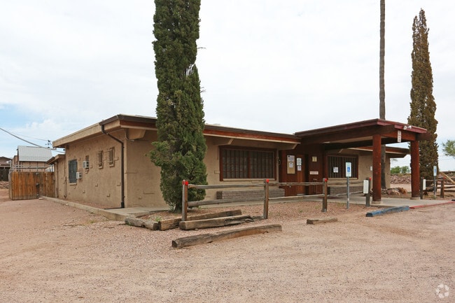

Property Detail
N Vista Rd
100-25-033D
N1/2 N1/2 SW SW NW OF SEC 15 1N 8E EXC THE W 350.13 AND THE E 33 THEREOF, AKA PARCEL B IN BK 22 OF SURVEYS PG 161, 1.05 AC
Residentialacreage
PINAL
UNDESIGNAT
Arizona
B and X Area of moderate flood hazard, usually the area between the limits of the 100-year and 500-year floods.
1.05 AC
2024
Apache Junction
2025
Phoenix
000310
Phoenix-Mesa-Chandler, AZ
NEARBY LISTINGS FOR SALE OR LEASE
DEMOGRAPHICS near N Vista Rd
1 mile
3 mile
5 mile
2025 Total Population
1,448
36,104
79,623
2030 Population
1,685
41,940
90,484
Pop Growth 2025-2030
+ 16.37%
+ 16.16%
+ 13.64%
Average Age
49
46
48
2025 Total Households
642
15,785
34,195
HH Growth 2025-2030
+ 16.20%
+ 15.91%
+ 14.13%
Median Household Inc
$52,069
$61,014
$66,049
Avg Household Size
2.20
2.20
2.30
2025 Avg HH Vehicles
2.00
2.00
2.00
Median Home Value
$351,724
$342,518
$324,205
Median Year Built
1989
1990
1994
Nearby Places
Map Layers
Map Styles
 Street
 Aerial
Transit
 Traffic
 Biking
Places
Listings with unknown addresses are not visible on the map
- Restaurants
- Banks
- Shops
- Fitness
- Groceries
PUBLIC TRANSPORTATION
AIRPORT
Phoenix-Mesa Gateway
Drive
Walk
Distance
Phoenix-Mesa Gateway
29 min
18.2 mi
Phoenix Sky Harbor International
Drive
Walk
Distance
Phoenix Sky Harbor International
43 min
31.0 mi
Freight Ports
Port of San Diego
Drive
Walk
Distance
Port of San Diego
433 min
390.7 mi
SALE & LEASE HISTORY
LISTING DATE
SALE/LEASE

Aug 29, 2022
For Sale
Apr 25, 2018
For Sale
Nearby Properties
Address
Land Use
TOTAL SIZE
Lot Size
Zoning
Address
Land Use
TOTAL SIZE
Lot Size
Zoning
117,169 SF
13.27 AC
Address
Land Use
TOTAL SIZE
Lot Size
Zoning
Address
Land Use
TOTAL SIZE
Lot Size
Zoning
108,644 SF
10.12 AC
UNDESIGNAT
Address
Land Use
TOTAL SIZE
Lot Size
Zoning
62,290 SF
7.53 AC
UNDESIGNAT
Address
Land Use
TOTAL SIZE
Lot Size
Zoning
69,692 SF
7.26 AC
Address
Land Use
TOTAL SIZE
Lot Size
Zoning
6,335 SF
8.30 AC
Address
Land Use
TOTAL SIZE
Lot Size
Zoning
11,686 SF
40 AC
Address
Land Use
TOTAL SIZE
Lot Size
Zoning
23,180 SF
3.90 AC
UNDESIGNAT
Address
Land Use
TOTAL SIZE
Lot Size
Zoning
26,022 SF
11.03 AC
UNDESIGNAT
Address
Land Use
TOTAL SIZE
Lot Size
Zoning
43,958 SF
4.54 AC
UNDESIGNAT
Address
Land Use
TOTAL SIZE
Lot Size
Zoning
54,300 SF
4.57 AC
UNDESIGNAT
Address
Land Use
TOTAL SIZE
Lot Size
Zoning
683 SF
36.74 AC
UNDESIGNAT
Address
Land Use
TOTAL SIZE
Lot Size
Zoning
24,158 SF
5.19 AC
Address
Land Use
TOTAL SIZE
Lot Size
Zoning
30,477 SF
3.91 AC
UNDESIGNAT
Address
Land Use
TOTAL SIZE
Lot Size
Zoning
Address
Land Use
TOTAL SIZE
Lot Size
Zoning
54,784 SF
5.36 AC
Address
Land Use
TOTAL SIZE
Lot Size
Zoning
34,441 SF
4.62 AC
UNDESIGNAT
Address
Land Use
TOTAL SIZE
Lot Size
Zoning
21,547 SF
4.25 AC
UNDESIGNAT
Address
Land Use
TOTAL SIZE
Lot Size
Zoning
19,977 SF
2.93 AC
UNDESIGNAT
Address
Land Use
TOTAL SIZE
Lot Size
Zoning
19,754 SF
11.67 AC
UNDESIGNAT
Address
Land Use
TOTAL SIZE
Lot Size
Zoning
560 SF
27.95 AC
UNDESIGNAT
Address
Land Use
TOTAL SIZE
Lot Size
Zoning
26,586 SF
4.51 AC
Address
Land Use
TOTAL SIZE
Lot Size
Zoning
20,123 SF
1 AC
UNDESIGNAT
Address
Land Use
TOTAL SIZE
Lot Size
Zoning
77,730 SF
6.15 AC
Address
Land Use
TOTAL SIZE
Lot Size
Zoning
23,349 SF
2.26 AC
Address
Land Use
TOTAL SIZE
Lot Size
Zoning
35,335 SF
13.79 AC
UNDESIGNAT
Address
Land Use
TOTAL SIZE
Lot Size
Zoning
3,516 SF
18.82 AC
UNDESIGNAT
Address
Land Use
TOTAL SIZE
Lot Size
Zoning
15,866 SF
2.40 AC
UNDESIGNAT
The World's #1 Commercial Real Estate Marketplace
Connect with us
© 2026 CoStar Group
The information above has been obtained from sources believed reliable. While we do not doubt its accuracy we have not verified it and make no guarantee, warranty or representation about it. It is your responsibility to independently confirm its accuracy and completeness. Any projections, opinions, assumptions, or estimates used are for example only and do not represent the current or future performance of the property. The value of this transaction to you depends on tax and other factors which should be evaluated by your tax, financial, and legal advisors. You and your advisors should conduct a careful, independent investigation of the property to determine to your satisfaction the suitability of the property for your needs.