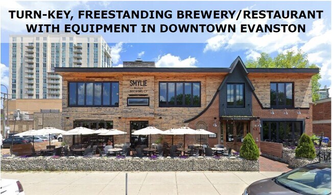
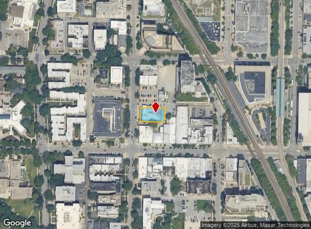
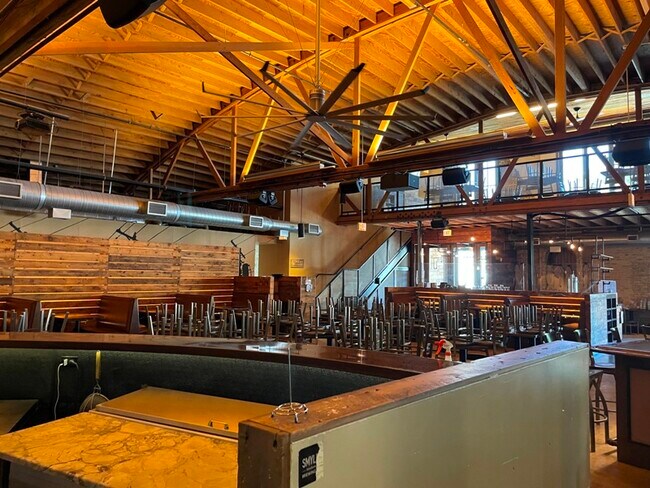
Property Record
1615 Oak Ave, Evanston, IL 60201

NEARBY LISTINGS FOR SALE OR LEASE
Property Detail
1615 Oak Ave
11-18-302-016-0000
Evanston
Commercialbuilding
Cook
X
Illinois
17031C0266K
8,7
2023
0.26 AC
2024
Near North
809500
Chicago
8,400 SF
Chicago-Naperville-Elgin, IL-IN-WI
DEMOGRAPHICS near 1615 Oak Ave
1 Mile
3 Mile
5 Mile
2024 Total Population
36,734
182,435
432,902
2029 Population
35,869
177,383
420,976
Pop Growth 2024-2029
(2.35%)
(2.77%)
(2.75%)
Average Age
37
40
41
2024 Total Households
14,458
71,590
172,328
HH Growth 2024-2029
(2.24%)
(2.98%)
(2.98%)
Median Household Inc
$66,356
$80,759
$72,709
Avg Household Size
2.00
2.30
2.30
2024 Avg HH Vehicles
1.00
1.00
1.00
Median Home Value
$453,254
$417,901
$390,314
Median Year Built
1958
1951
1952
Nearby Places
Map Layers
Map Styles
 Street
 Aerial
- Restaurants
- Banks
- Shops
- Fitness
- Groceries
PUBLIC TRANSPORTATION
TRANSIT/SUBWAY
Davis Station (Purple Line - Chicago Transit Authority "L" Trains (The "L"))
DRIVE
WALK
Distance
Davis Station (Purple Line - Chicago Transit Authority "L" Trains (The "L"))
0 min
4 min
0.2 mi
Dempster Station (Purple Line - Chicago Transit Authority "L" Trains (The "L"))
DRIVE
WALK
Distance
Dempster Station (Purple Line - Chicago Transit Authority "L" Trains (The "L"))
1 min
11 min
0.6 mi
Foster Station (Purple Line - Chicago Transit Authority "L" Trains (The "L"))
DRIVE
WALK
Distance
Foster Station (Purple Line - Chicago Transit Authority "L" Trains (The "L"))
1 min
12 min
0.6 mi
Noyes Station (Purple Line - Chicago Transit Authority "L" Trains (The "L"))
DRIVE
WALK
Distance
Noyes Station (Purple Line - Chicago Transit Authority "L" Trains (The "L"))
2 min
17 min
0.9 mi
COMMUTER RAIL
Evanston Davis Street Station (Union Pacific North Line - Northeast Illinois Regional Commuter Railroad (Metra))
DRIVE
WALK
Distance
Evanston Davis Street Station (Union Pacific North Line - Northeast Illinois Regional Commuter Railroad (Metra))
0 min
3 min
0.2 mi
Evanston Main Street Station (Union Pacific North Line - Northeast Illinois Regional Commuter Railroad (Metra))
DRIVE
WALK
Distance
Evanston Main Street Station (Union Pacific North Line - Northeast Illinois Regional Commuter Railroad (Metra))
3 min
1.4 mi
AIRPORT
Chicago O'Hare International
DRIVE
WALK
Distance
Chicago O'Hare International
28 min
15.3 mi
Chicago Midway International
DRIVE
WALK
Distance
Chicago Midway International
38 min
24.8 mi
Freight Ports
Port Milwaukee
DRIVE
WALK
Distance
Port Milwaukee
91 min
73.4 mi
SALE & LEASE HISTORY
LISTING DATE
SALE/LEASE

Nov 04, 2022
For Lease
Nov 01, 2022
For Lease
Nearby Properties
Address
Land Use
TOTAL SIZE
Lot Size
Zoning
Address
Land Use
TOTAL SIZE
Lot Size
Zoning
180,397 SF
0.78 AC
Address
Land Use
TOTAL SIZE
Lot Size
Zoning
0.63 AC
Address
Land Use
TOTAL SIZE
Lot Size
Zoning
341,698 SF
0.64 AC
Address
Land Use
TOTAL SIZE
Lot Size
Zoning
305,592 SF
27.35 AC
Address
Land Use
TOTAL SIZE
Lot Size
Zoning
82,139 SF
4.88 AC
Address
Land Use
TOTAL SIZE
Lot Size
Zoning
892,012 SF
37.29 AC
Address
Land Use
TOTAL SIZE
Lot Size
Zoning
2.10 AC
Address
Land Use
TOTAL SIZE
Lot Size
Zoning
218,982 SF
1.97 AC
Address
Land Use
TOTAL SIZE
Lot Size
Zoning
372,244 SF
7.12 AC
Address
Land Use
TOTAL SIZE
Lot Size
Zoning
303,960 SF
0.98 AC
Address
Land Use
TOTAL SIZE
Lot Size
Zoning
251,409 SF
16.33 AC
Address
Land Use
TOTAL SIZE
Lot Size
Zoning
176,115 SF
1.04 AC
Address
Land Use
TOTAL SIZE
Lot Size
Zoning
0.84 AC
Address
Land Use
TOTAL SIZE
Lot Size
Zoning
110,528 SF
3.05 AC
Address
Land Use
TOTAL SIZE
Lot Size
Zoning
1.67 AC
Address
Land Use
TOTAL SIZE
Lot Size
Zoning
163,981 SF
4 AC
Address
Land Use
TOTAL SIZE
Lot Size
Zoning
5.65 AC
Address
Land Use
TOTAL SIZE
Lot Size
Zoning
145,548 SF
0.80 AC
Address
Land Use
TOTAL SIZE
Lot Size
Zoning
243,781 SF
0.84 AC
Address
Land Use
TOTAL SIZE
Lot Size
Zoning
0.30 AC
Address
Land Use
TOTAL SIZE
Lot Size
Zoning
208,785 SF
0.61 AC
Address
Land Use
TOTAL SIZE
Lot Size
Zoning
0.84 AC
Address
Land Use
TOTAL SIZE
Lot Size
Zoning
0.38 AC
Address
Land Use
TOTAL SIZE
Lot Size
Zoning
223,366 SF
0.65 AC
Address
Land Use
TOTAL SIZE
Lot Size
Zoning
70,792 SF
1.40 AC
PD 631
Address
Land Use
TOTAL SIZE
Lot Size
Zoning
72,503 SF
5.60 AC
Address
Land Use
TOTAL SIZE
Lot Size
Zoning
0.25 AC
Address
Land Use
TOTAL SIZE
Lot Size
Zoning
0.21 AC
Address
Land Use
TOTAL SIZE
Lot Size
Zoning
88,782 SF
0.52 AC
Address
Land Use
TOTAL SIZE
Lot Size
Zoning
136,138 SF
9.82 AC
The World's #1 Commercial Real Estate Marketplace
Connect with us
© 2025 CoStar Group
The information above has been obtained from sources believed reliable. While we do not doubt its accuracy we have not verified it and make no guarantee, warranty or representation about it. It is your responsibility to independently confirm its accuracy and completeness. Any projections, opinions, assumptions, or estimates used are for example only and do not represent the current or future performance of the property. The value of this transaction to you depends on tax and other factors which should be evaluated by your tax, financial, and legal advisors. You and your advisors should conduct a careful, independent investigation of the property to determine to your satisfaction the suitability of the property for your needs.