Property Record
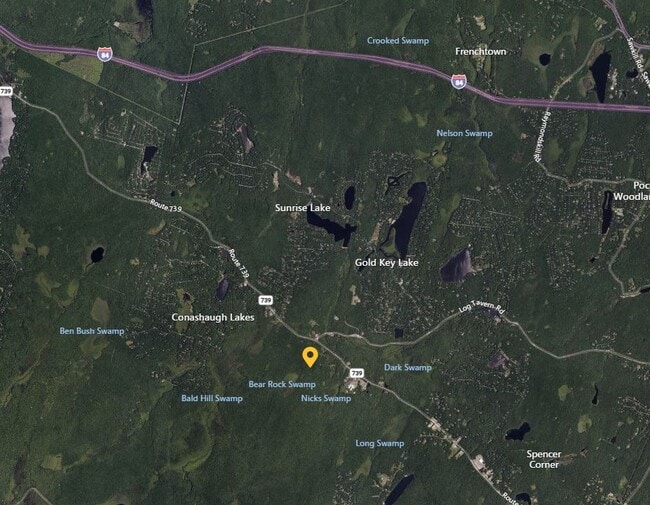
1615 Route 739, Dingmans Ferry, PA 18328

Property Detail
1615 Route 739
028402
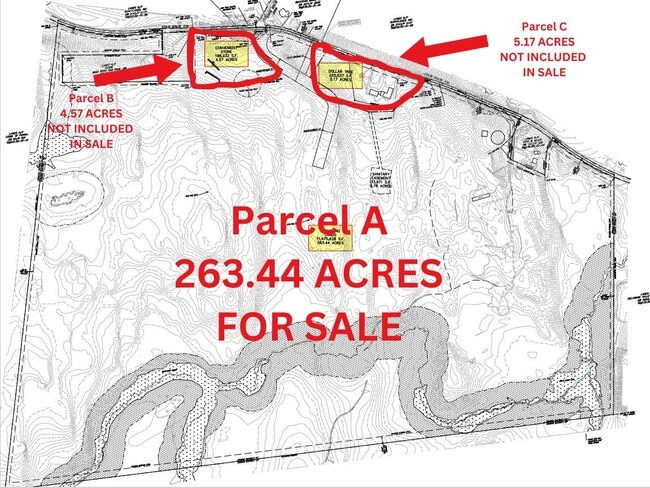
313.81 AC ACT319 2 HOUSES BARN
Agriculturalland
PIKE
B and X Area of moderate flood hazard, usually the area between the limits of the 100-year and 500-year floods.
Pennsylvania
2024
313.81 AC
2025
Pike County
950702
Northern New Jersey
6,653 SF
Hemlock Farms, PA
NEARBY LISTINGS FOR SALE OR LEASE
DEMOGRAPHICS near 1615 Route 739
1 mile
3 mile
5 mile
2025 Total Population
394
6,733
15,650
2030 Population
398
6,824
15,872
Pop Growth 2025-2030
+ 1.02%
+ 1.35%
+ 1.42%
Average Age
43
42
42
2025 Total Households
153
2,565
5,862
HH Growth 2025-2030
+ 0.65%
+ 1.17%
+ 1.26%
Median Household Inc
$84,615
$84,404
$86,518
Avg Household Size
2.50
2.60
2.60
2025 Avg HH Vehicles
2.00
2.00
2.00
Median Home Value
$228,378
$227,778
$246,727
Median Year Built
1979
1983
1986
Nearby Places
Map Layers
Map Styles
 Street
 Aerial
Layers
 Traffic
 Biking
Places
Listings with unknown addresses are not visible on the map
- Restaurants
- Banks
- Shops
- Fitness
- Groceries
SALE & LEASE HISTORY
LISTING DATE
SALE/LEASE

Dec 04, 2024
For Sale
Nearby Properties
Address
Land Use
TOTAL SIZE
Lot Size
Zoning
Address
Land Use
TOTAL SIZE
Lot Size
Zoning
97,922 SF
40.33 AC
Address
Land Use
TOTAL SIZE
Lot Size
Zoning
47,243 SF
1.65 AC
Address
Land Use
TOTAL SIZE
Lot Size
Zoning
12,253 SF
143.61 AC
Address
Land Use
TOTAL SIZE
Lot Size
Zoning
10,289 SF
21.64 AC
Address
Land Use
TOTAL SIZE
Lot Size
Zoning
43,183 SF
719 AC
Address
Land Use
TOTAL SIZE
Lot Size
Zoning
12,586 SF
48.90 AC
Address
Land Use
TOTAL SIZE
Lot Size
Zoning
34,188 SF
5 AC
Address
Land Use
TOTAL SIZE
Lot Size
Zoning
12,194 SF
5.39 AC
Address
Land Use
TOTAL SIZE
Lot Size
Zoning
11,153 SF
17.20 AC
Address
Land Use
TOTAL SIZE
Lot Size
Zoning
11,056 SF
10.30 AC
Address
Land Use
TOTAL SIZE
Lot Size
Zoning
2,164 SF
531.62 AC
Address
Land Use
TOTAL SIZE
Lot Size
Zoning
2,880 SF
540.90 AC
Address
Land Use
TOTAL SIZE
Lot Size
Zoning
5,438 SF
41.61 AC
Address
Land Use
TOTAL SIZE
Lot Size
Zoning
8,590 SF
0.48 AC
Address
Land Use
TOTAL SIZE
Lot Size
Zoning
10,765 SF
10.46 AC
Address
Land Use
TOTAL SIZE
Lot Size
Zoning
3,250 SF
382 AC
Address
Land Use
TOTAL SIZE
Lot Size
Zoning
7,000 SF
2.76 AC
Address
Land Use
TOTAL SIZE
Lot Size
Zoning
9,828 SF
5.46 AC
Address
Land Use
TOTAL SIZE
Lot Size
Zoning
9,384 SF
10.37 AC
Address
Land Use
TOTAL SIZE
Lot Size
Zoning
9,682 SF
3.29 AC
Address
Land Use
TOTAL SIZE
Lot Size
Zoning
9,220 SF
3.73 AC
Address
Land Use
TOTAL SIZE
Lot Size
Zoning
4,312 SF
2.81 AC
Address
Land Use
TOTAL SIZE
Lot Size
Zoning
5,737 SF
75.40 AC
Address
Land Use
TOTAL SIZE
Lot Size
Zoning
4,124 SF
43.83 AC
Address
Land Use
TOTAL SIZE
Lot Size
Zoning
440.70 AC
Address
Land Use
TOTAL SIZE
Lot Size
Zoning
1,068 SF
193.32 AC
Address
Land Use
TOTAL SIZE
Lot Size
Zoning
6,360 SF
3.45 AC
Address
Land Use
TOTAL SIZE
Lot Size
Zoning
5,069 SF
25.83 AC
The World's #1 Commercial Real Estate Marketplace
Connect with us
© 2026 CoStar Group
The information above has been obtained from sources believed reliable. While we do not doubt its accuracy we have not verified it and make no guarantee, warranty or representation about it. It is your responsibility to independently confirm its accuracy and completeness. Any projections, opinions, assumptions, or estimates used are for example only and do not represent the current or future performance of the property. The value of this transaction to you depends on tax and other factors which should be evaluated by your tax, financial, and legal advisors. You and your advisors should conduct a careful, independent investigation of the property to determine to your satisfaction the suitability of the property for your needs.