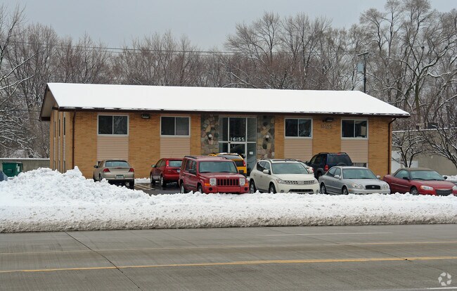
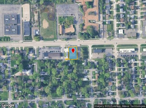
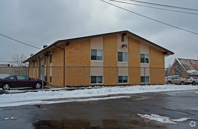
Property Record
16155 W 12 Mile Rd, Southfield, MI 48076
NEARBY LISTINGS FOR SALE OR LEASE
Property Detail
16155 W 12 Mile Rd
24-13-204-002
Bonnie Acres Sub
Officebuilding
T1N,R10E,SEC 13 15-19 BONNIE ACRES SUB NO 1 LOTS 15 TO 19 INCL, ALSO N 1/2 OF VAC ALLEY ADJ TO SAME, ALSO S 1/2 OF VAC ALLEY
X
Oakland
26125C0539F
Michigan
2024
0.35 AC
2022
Southfield
161300
Detroit
5,590 SF
Detroit-Warren-Dearborn, MI
DEMOGRAPHICS near 16155 W 12 Mile Rd
1 Mile
3 Mile
5 Mile
2024 Total Population
14,891
119,326
296,393
2029 Population
14,707
117,976
293,182
Pop Growth 2024-2029
(1.24%)
(1.13%)
(1.08%)
Average Age
40
42
41
2024 Total Households
6,477
52,267
132,470
HH Growth 2024-2029
(1.19%)
(1.09%)
(1.06%)
Median Household Inc
$75,921
$87,176
$81,703
Avg Household Size
2.20
2.20
2.20
2024 Avg HH Vehicles
2.00
2.00
2.00
Median Home Value
$222,761
$273,225
$263,406
Median Year Built
1957
1959
1958
Nearby Places
Map Layers
Map Styles
 Street
 Aerial
- Restaurants
- Banks
- Shops
- Fitness
- Groceries
PUBLIC TRANSPORTATION
COMMUTER RAIL
DRIVE
WALK
Distance
10 min
3.9 mi
DRIVE
WALK
Distance
11 min
4.6 mi
AIRPORT
Windsor International
DRIVE
WALK
Distance
Windsor International
50 min
27.0 mi
Detroit Metro Wayne County
DRIVE
WALK
Distance
Detroit Metro Wayne County
43 min
27.8 mi
Nearby Properties
Address
Land Use
TOTAL SIZE
Lot Size
Zoning
Address
Land Use
TOTAL SIZE
Lot Size
Zoning
2,373,792 SF
17.35 AC
RC
Address
Land Use
TOTAL SIZE
Lot Size
Zoning
350,140 SF
37.78 AC
RC
Address
Land Use
TOTAL SIZE
Lot Size
Zoning
882,862 SF
8.22 AC
RC
Address
Land Use
TOTAL SIZE
Lot Size
Zoning
588 SF
53.02 AC
RM
Address
Land Use
TOTAL SIZE
Lot Size
Zoning
460,062 SF
10.01 AC
RC
Address
Land Use
TOTAL SIZE
Lot Size
Zoning
187,801 SF
5.49 AC
RM-2
Address
Land Use
TOTAL SIZE
Lot Size
Zoning
149,395 SF
1.02 AC
BI
Address
Land Use
TOTAL SIZE
Lot Size
Zoning
535,287 SF
9.26 AC
RC
Address
Land Use
TOTAL SIZE
Lot Size
Zoning
15.32 AC
GEN BUS
Address
Land Use
TOTAL SIZE
Lot Size
Zoning
859,104 SF
9.59 AC
RC
Address
Land Use
TOTAL SIZE
Lot Size
Zoning
99,661 SF
0.62 AC
Address
Land Use
TOTAL SIZE
Lot Size
Zoning
236,140 SF
1.67 AC
BI
Address
Land Use
TOTAL SIZE
Lot Size
Zoning
655,519 SF
9.18 AC
ERO
Address
Land Use
TOTAL SIZE
Lot Size
Zoning
170,465 SF
4.84 AC
BV
Address
Land Use
TOTAL SIZE
Lot Size
Zoning
280,500 SF
3.58 AC
RC
Address
Land Use
TOTAL SIZE
Lot Size
Zoning
350,140 SF
27.11 AC
RC
Address
Land Use
TOTAL SIZE
Lot Size
Zoning
83,244 SF
0.38 AC
Address
Land Use
TOTAL SIZE
Lot Size
Zoning
344,960 SF
8.90 AC
RC
Address
Land Use
TOTAL SIZE
Lot Size
Zoning
72,457 SF
5.60 AC
OFFICE SVC
Address
Land Use
TOTAL SIZE
Lot Size
Zoning
120,093 SF
38.18 AC
TV-R
Address
Land Use
TOTAL SIZE
Lot Size
Zoning
84,711 SF
5.05 AC
BI
Address
Land Use
TOTAL SIZE
Lot Size
Zoning
79,935 SF
1.02 AC
BI
Address
Land Use
TOTAL SIZE
Lot Size
Zoning
109,570 SF
0.68 AC
BI
Address
Land Use
TOTAL SIZE
Lot Size
Zoning
245,740 SF
1.06 AC
BI
Address
Land Use
TOTAL SIZE
Lot Size
Zoning
301,276 SF
13.58 AC
AI
Address
Land Use
TOTAL SIZE
Lot Size
Zoning
339,780 SF
22.29 AC
RM-1
Address
Land Use
TOTAL SIZE
Lot Size
Zoning
24.30 AC
GEN BUS
Address
Land Use
TOTAL SIZE
Lot Size
Zoning
212 SF
16.59 AC
RM
Address
Land Use
TOTAL SIZE
Lot Size
Zoning
417,880 SF
6.76 AC
RM-2
Address
Land Use
TOTAL SIZE
Lot Size
Zoning
183,090 SF
15.25 AC
RM
The World's #1 Commercial Real Estate Marketplace
Connect with us
© 2025 CoStar Group
The information above has been obtained from sources believed reliable. While we do not doubt its accuracy we have not verified it and make no guarantee, warranty or representation about it. It is your responsibility to independently confirm its accuracy and completeness. Any projections, opinions, assumptions, or estimates used are for example only and do not represent the current or future performance of the property. The value of this transaction to you depends on tax and other factors which should be evaluated by your tax, financial, and legal advisors. You and your advisors should conduct a careful, independent investigation of the property to determine to your satisfaction the suitability of the property for your needs.