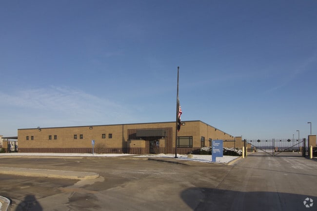
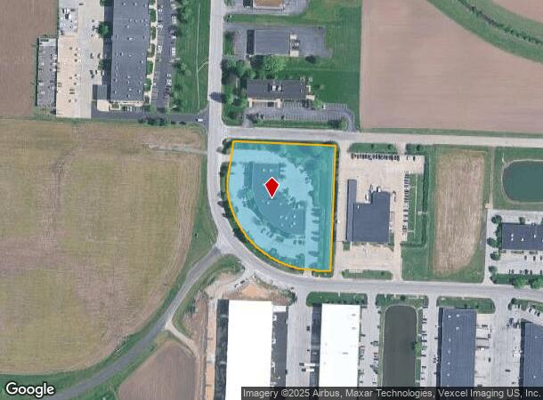
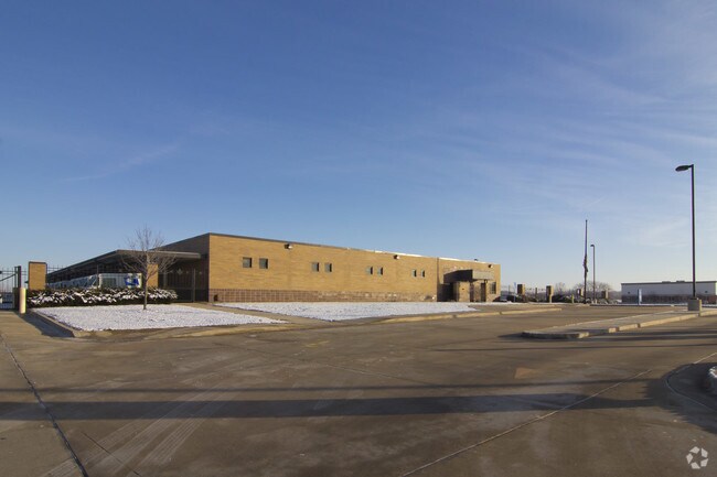
Property Record
1218 Eastport Plaza Dr, Collinsville, IL 62234
NEARBY LISTINGS FOR SALE OR LEASE
Property Detail
1218 Eastport Plaza Dr
St. Louis
Dellamano Acres
St. Louis, MO-IL
DELLAMANO ACRES LOT 1 476.84 X 446.76 IRREGULAR
13-2-21-30-08-201-001
Madison
Warehouse
Illinois
2024
1
2024
4.89 AC
403300
Illinois
23,600 SF
DEMOGRAPHICS near 1218 Eastport Plaza Dr
1 Mile
3 Mile
5 Mile
2024 Total Population
840
26,582
59,126
2029 Population
858
26,346
58,533
Pop Growth 2024-2029
+ 2.14%
(0.89%)
(1.00%)
Average Age
39
40
41
2024 Total Households
381
11,289
24,325
HH Growth 2024-2029
+ 2.10%
(0.96%)
(1.05%)
Median Household Inc
$52,333
$57,933
$63,901
Avg Household Size
2.20
2.30
2.40
2024 Avg HH Vehicles
2.00
2.00
2.00
Median Home Value
$154,545
$139,282
$150,398
Median Year Built
1977
1969
1973
Nearby Places
Map Layers
Map Styles
 Street
 Aerial
- Restaurants
- Banks
- Shops
- Fitness
- Groceries
PUBLIC TRANSPORTATION
COMMUTER RAIL
Fairview Heights (Lambert Airport Shiloh-Scott - St. Louis MetroLink (MetroLink), Shrewsbury-Lansdowne I-44 Emerson Park - St. Louis MetroLink (MetroLink))
DRIVE
WALK
Distance
Fairview Heights (Lambert Airport Shiloh-Scott - St. Louis MetroLink (MetroLink), Shrewsbury-Lansdowne I-44 Emerson Park - St. Louis MetroLink (MetroLink))
16 min
8.3 mi
Washington Park (Lambert Airport Shiloh-Scott - St. Louis MetroLink (MetroLink), Shrewsbury-Lansdowne I-44 Emerson Park - St. Louis MetroLink (MetroLink))
DRIVE
WALK
Distance
Washington Park (Lambert Airport Shiloh-Scott - St. Louis MetroLink (MetroLink), Shrewsbury-Lansdowne I-44 Emerson Park - St. Louis MetroLink (MetroLink))
14 min
9.5 mi
AIRPORT
Scott AFB/Midamerica St Louis
DRIVE
WALK
Distance
Scott AFB/Midamerica St Louis
39 min
23.1 mi
St Louis Lambert International
DRIVE
WALK
Distance
St Louis Lambert International
36 min
24.9 mi
Nearby Properties
Address
Land Use
TOTAL SIZE
Lot Size
Zoning
Address
Land Use
TOTAL SIZE
Lot Size
Zoning
148,997 SF
10 AC
Address
Land Use
TOTAL SIZE
Lot Size
Zoning
216,370 SF
23.25 AC
Address
Land Use
TOTAL SIZE
Lot Size
Zoning
131,296 SF
14.60 AC
Address
Land Use
TOTAL SIZE
Lot Size
Zoning
48,640 SF
3.84 AC
Address
Land Use
TOTAL SIZE
Lot Size
Zoning
Address
Land Use
TOTAL SIZE
Lot Size
Zoning
25,743 SF
3.49 AC
Address
Land Use
TOTAL SIZE
Lot Size
Zoning
54,699 SF
2.20 AC
Address
Land Use
TOTAL SIZE
Lot Size
Zoning
57,825 SF
2.68 AC
Address
Land Use
TOTAL SIZE
Lot Size
Zoning
32,331 SF
14.98 AC
Address
Land Use
TOTAL SIZE
Lot Size
Zoning
57,342 SF
Address
Land Use
TOTAL SIZE
Lot Size
Zoning
8,176 SF
61.11 AC
Address
Land Use
TOTAL SIZE
Lot Size
Zoning
3,868 SF
0.22 AC
Address
Land Use
TOTAL SIZE
Lot Size
Zoning
40,168 SF
1.08 AC
Address
Land Use
TOTAL SIZE
Lot Size
Zoning
40,430 SF
Address
Land Use
TOTAL SIZE
Lot Size
Zoning
84,816 SF
0.89 AC
Address
Land Use
TOTAL SIZE
Lot Size
Zoning
Address
Land Use
TOTAL SIZE
Lot Size
Zoning
756 SF
8.77 AC
Address
Land Use
TOTAL SIZE
Lot Size
Zoning
35,940 SF
1.50 AC
Address
Land Use
TOTAL SIZE
Lot Size
Zoning
50,400 SF
6.67 AC
Address
Land Use
TOTAL SIZE
Lot Size
Zoning
5,475 SF
2.91 AC
Address
Land Use
TOTAL SIZE
Lot Size
Zoning
1,600 SF
67.01 AC
Address
Land Use
TOTAL SIZE
Lot Size
Zoning
46,660 SF
3.50 AC
Address
Land Use
TOTAL SIZE
Lot Size
Zoning
64,411 SF
1.80 AC
Address
Land Use
TOTAL SIZE
Lot Size
Zoning
39,750 SF
3.90 AC
Address
Land Use
TOTAL SIZE
Lot Size
Zoning
31,041 SF
1.62 AC
Address
Land Use
TOTAL SIZE
Lot Size
Zoning
9,904 SF
5.50 AC
Address
Land Use
TOTAL SIZE
Lot Size
Zoning
31,240 SF
5.63 AC
Address
Land Use
TOTAL SIZE
Lot Size
Zoning
35,900 SF
3.28 AC
Address
Land Use
TOTAL SIZE
Lot Size
Zoning
40,994 SF
4 AC
Address
Land Use
TOTAL SIZE
Lot Size
Zoning
30,670 SF
2.36 AC
The World's #1 Commercial Real Estate Marketplace
Connect with us
© 2025 CoStar Group
The information above has been obtained from sources believed reliable. While we do not doubt its accuracy we have not verified it and make no guarantee, warranty or representation about it. It is your responsibility to independently confirm its accuracy and completeness. Any projections, opinions, assumptions, or estimates used are for example only and do not represent the current or future performance of the property. The value of this transaction to you depends on tax and other factors which should be evaluated by your tax, financial, and legal advisors. You and your advisors should conduct a careful, independent investigation of the property to determine to your satisfaction the suitability of the property for your needs.