Property Record
1616 Maxwellton St, San Luis Obispo, CA 93401


NEARBY LISTINGS FOR SALE OR LEASE
-
-
View all San Luis Obispo listings for sale on LoopNet.com
Property Detail
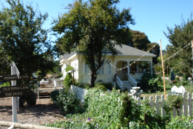
1616 Maxwellton St
044-131-032
The Ranchos Corral De Piedra
Miscresidentialimprovement
TN MAX PTN & PTN ABD HWY
A
San Luis Obispo
06079C1355G
California
2024
1.56 AC
2025
South 101 Corridor
011600
San Luis Obispo/Paso Robles
2,018 SF
San Luis Obispo-Paso Robles-Arroyo Grande, CA
DEMOGRAPHICS near 1616 Maxwellton St
1 Mile
3 Mile
5 Mile
2024 Total Population
638
2,567
30,692
2029 Population
623
2,501
30,821
Pop Growth 2024-2029
(2.35%)
(2.57%)
+ 0.42%
Average Age
47
46
45
2024 Total Households
252
966
13,232
HH Growth 2024-2029
(2.38%)
(2.80%)
+ 0.39%
Median Household Inc
$147,726
$145,774
$98,324
Avg Household Size
2.50
2.50
2.20
2024 Avg HH Vehicles
3.00
3.00
2.00
Median Home Value
$1,102,147
$1,095,667
$900,504
Median Year Built
1982
1982
1984
Nearby Places
Map Layers
Map Styles
 Street
 Aerial
- Restaurants
- Banks
- Shops
- Fitness
- Groceries
PUBLIC TRANSPORTATION
COMMUTER RAIL
San Luis Obispo (Coast Starlight - Amtrak, Pacific Surfliner - Amtrak)
DRIVE
WALK
Distance
San Luis Obispo (Coast Starlight - Amtrak, Pacific Surfliner - Amtrak)
10 min
6.1 mi
Grover Beach Amtrak (Pacific Surfliner - Amtrak)
DRIVE
WALK
Distance
Grover Beach Amtrak (Pacific Surfliner - Amtrak)
11 min
6.8 mi
AIRPORT
San Luis County Regional
DRIVE
WALK
Distance
San Luis County Regional
6 min
3.2 mi
Freight Ports
The Port of Hueneme
DRIVE
WALK
Distance
The Port of Hueneme
163 min
126.1 mi
Nearby Properties
Address
Land Use
TOTAL SIZE
Lot Size
Zoning
Address
Land Use
TOTAL SIZE
Lot Size
Zoning
Address
Land Use
TOTAL SIZE
Lot Size
Zoning
69,091 SF
20.41 AC
AG
Address
Land Use
TOTAL SIZE
Lot Size
Zoning
46,390 SF
5.26 AC
CS
Address
Land Use
TOTAL SIZE
Lot Size
Zoning
114,262 SF
5.70 AC
IND
Address
Land Use
TOTAL SIZE
Lot Size
Zoning
66,008 SF
10.75 AC
IND
Address
Land Use
TOTAL SIZE
Lot Size
Zoning
Address
Land Use
TOTAL SIZE
Lot Size
Zoning
36,668 SF
129.30 AC
REC
Address
Land Use
TOTAL SIZE
Lot Size
Zoning
141,309 SF
9.98 AC
RS
Address
Land Use
TOTAL SIZE
Lot Size
Zoning
41,976 SF
48.60 AC
AG
Address
Land Use
TOTAL SIZE
Lot Size
Zoning
2,160 SF
63.10 AC
AG
Address
Land Use
TOTAL SIZE
Lot Size
Zoning
23,907 SF
1.65 AC
CS
Address
Land Use
TOTAL SIZE
Lot Size
Zoning
36,620 SF
62.61 AC
AG
Address
Land Use
TOTAL SIZE
Lot Size
Zoning
27,949 SF
2.54 AC
CS
Address
Land Use
TOTAL SIZE
Lot Size
Zoning
115 AC
AG
Address
Land Use
TOTAL SIZE
Lot Size
Zoning
1,241 SF
218 AC
RL
Address
Land Use
TOTAL SIZE
Lot Size
Zoning
18,959 SF
2.54 AC
CS
Address
Land Use
TOTAL SIZE
Lot Size
Zoning
1,254.33 AC
AG
Address
Land Use
TOTAL SIZE
Lot Size
Zoning
26,214 SF
2.25 AC
CS
Address
Land Use
TOTAL SIZE
Lot Size
Zoning
Address
Land Use
TOTAL SIZE
Lot Size
Zoning
14,498 SF
1.32 AC
CS
Address
Land Use
TOTAL SIZE
Lot Size
Zoning
461 AC
RL
Address
Land Use
TOTAL SIZE
Lot Size
Zoning
20,208 SF
1.75 AC
CS
Address
Land Use
TOTAL SIZE
Lot Size
Zoning
118.09 AC
Address
Land Use
TOTAL SIZE
Lot Size
Zoning
1.03 AC
CS
Address
Land Use
TOTAL SIZE
Lot Size
Zoning
19,355 SF
1.94 AC
CS
Address
Land Use
TOTAL SIZE
Lot Size
Zoning
26,732 SF
2.26 AC
CS
Address
Land Use
TOTAL SIZE
Lot Size
Zoning
61.69 AC
Address
Land Use
TOTAL SIZE
Lot Size
Zoning
315.92 AC
AG
Address
Land Use
TOTAL SIZE
Lot Size
Zoning
63.22 AC
Address
Land Use
TOTAL SIZE
Lot Size
Zoning
15,756 SF
2.97 AC
CS
The World's #1 Commercial Real Estate Marketplace
Connect with us
© 2025 CoStar Group
The information above has been obtained from sources believed reliable. While we do not doubt its accuracy we have not verified it and make no guarantee, warranty or representation about it. It is your responsibility to independently confirm its accuracy and completeness. Any projections, opinions, assumptions, or estimates used are for example only and do not represent the current or future performance of the property. The value of this transaction to you depends on tax and other factors which should be evaluated by your tax, financial, and legal advisors. You and your advisors should conduct a careful, independent investigation of the property to determine to your satisfaction the suitability of the property for your needs.