Property Record
1618 S Burnside Ave, Prairieville, LA 70769

NEARBY LISTINGS FOR SALE OR LEASE
Property Detail
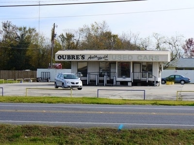
1618 S Burnside Ave
Baton Rouge, LA
7 Ps
22003-448
PUBLIC SERVICE GONZALES SERVICE CENTER SITE - A 3.22 ACRE TRACT OF LAND SITUATED IN THE NE/4 OF SEC. 32, T9S, R3E, AT THE INT
Pipelinestransmissiondistributionfieldgatheringandallothertypesincludingdistributionconnections
Ascension
X
Louisiana
22005C0110E
a
2024
2.22 AC
2024
Ascension Parish
030402
Baton Rouge
DEMOGRAPHICS near 1618 S Burnside Ave
1 Mile
3 Mile
5 Mile
2024 Total Population
7,699
24,763
63,906
2029 Population
8,405
27,045
69,445
Pop Growth 2024-2029
+ 9.17%
+ 9.22%
+ 8.67%
Average Age
39
39
38
2024 Total Households
2,834
9,546
23,809
HH Growth 2024-2029
+ 9.42%
+ 9.56%
+ 8.96%
Median Household Inc
$53,774
$54,298
$66,998
Avg Household Size
2.60
2.50
2.60
2024 Avg HH Vehicles
2.00
2.00
2.00
Median Home Value
$163,110
$182,574
$216,950
Median Year Built
1988
1996
2001
Nearby Places
Map Layers
Map Styles
 Street
 Aerial
- Restaurants
- Banks
- Shops
- Fitness
- Groceries
PUBLIC TRANSPORTATION
AIRPORT
Baton Rouge Metro Ryan Field
DRIVE
WALK
Distance
Baton Rouge Metro Ryan Field
39 min
26.7 mi
Freight Ports
Port of Greater Baton Rouge
DRIVE
WALK
Distance
Port of Greater Baton Rouge
36 min
27.9 mi
Nearby Properties
Address
Land Use
TOTAL SIZE
Lot Size
Zoning
Address
Land Use
TOTAL SIZE
Lot Size
Zoning
32.25 AC
Address
Land Use
TOTAL SIZE
Lot Size
Zoning
Address
Land Use
TOTAL SIZE
Lot Size
Zoning
10.83 AC
Address
Land Use
TOTAL SIZE
Lot Size
Zoning
29.24 AC
Address
Land Use
TOTAL SIZE
Lot Size
Zoning
Address
Land Use
TOTAL SIZE
Lot Size
Zoning
48.53 AC
C
Address
Land Use
TOTAL SIZE
Lot Size
Zoning
13.83 AC
Address
Land Use
TOTAL SIZE
Lot Size
Zoning
13.65 AC
Address
Land Use
TOTAL SIZE
Lot Size
Zoning
Address
Land Use
TOTAL SIZE
Lot Size
Zoning
34.31 AC
Address
Land Use
TOTAL SIZE
Lot Size
Zoning
34.85 AC
MU
Address
Land Use
TOTAL SIZE
Lot Size
Zoning
Address
Land Use
TOTAL SIZE
Lot Size
Zoning
15.82 AC
Address
Land Use
TOTAL SIZE
Lot Size
Zoning
9.91 AC
MU
Address
Land Use
TOTAL SIZE
Lot Size
Zoning
235.99 AC
C
Address
Land Use
TOTAL SIZE
Lot Size
Zoning
13.02 AC
Address
Land Use
TOTAL SIZE
Lot Size
Zoning
9.72 AC
Address
Land Use
TOTAL SIZE
Lot Size
Zoning
10.48 AC
Address
Land Use
TOTAL SIZE
Lot Size
Zoning
Address
Land Use
TOTAL SIZE
Lot Size
Zoning
Address
Land Use
TOTAL SIZE
Lot Size
Zoning
5.41 AC
MU
Address
Land Use
TOTAL SIZE
Lot Size
Zoning
1.88 AC
Address
Land Use
TOTAL SIZE
Lot Size
Zoning
11.98 AC
Address
Land Use
TOTAL SIZE
Lot Size
Zoning
10.50 AC
BP
Address
Land Use
TOTAL SIZE
Lot Size
Zoning
2.84 AC
Address
Land Use
TOTAL SIZE
Lot Size
Zoning
Address
Land Use
TOTAL SIZE
Lot Size
Zoning
Address
Land Use
TOTAL SIZE
Lot Size
Zoning
7.12 AC
Address
Land Use
TOTAL SIZE
Lot Size
Zoning
1.44 AC
The World's #1 Commercial Real Estate Marketplace
Connect with us
© 2025 CoStar Group
The information above has been obtained from sources believed reliable. While we do not doubt its accuracy we have not verified it and make no guarantee, warranty or representation about it. It is your responsibility to independently confirm its accuracy and completeness. Any projections, opinions, assumptions, or estimates used are for example only and do not represent the current or future performance of the property. The value of this transaction to you depends on tax and other factors which should be evaluated by your tax, financial, and legal advisors. You and your advisors should conduct a careful, independent investigation of the property to determine to your satisfaction the suitability of the property for your needs.