Property Record
1619 Lisenby Ave, Panama City, FL 32405
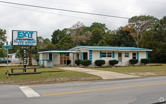
This Property Is For Sale
NEARBY LISTINGS FOR SALE OR LEASE
Property Detail
1619 Lisenby Ave
Panama City, FL
St Andrews Railroad & Mining
13903-000-000
31 3S 14W S1/2 OF SW1/4 LOT 1 BLK 17 ORB 4174 P 1599
Commercialnec
Bay
X
Florida
12005C0341J
1
2023
0.21 AC
2024
St Andrews
002200
Other Market Areas
988 SF
DEMOGRAPHICS near 1619 Lisenby Ave
1 Mile
3 Mile
5 Mile
2024 Total Population
6,438
29,111
69,057
2029 Population
6,703
30,831
73,251
Pop Growth 2024-2029
+ 4.12%
+ 5.91%
+ 6.07%
Average Age
39
41
41
2024 Total Households
2,652
11,962
27,968
HH Growth 2024-2029
+ 4.64%
+ 6.42%
+ 6.71%
Median Household Inc
$48,532
$54,206
$56,324
Avg Household Size
2.30
2.30
2.40
2024 Avg HH Vehicles
1.00
2.00
2.00
Median Home Value
$144,972
$207,764
$220,665
Median Year Built
1969
1980
1986
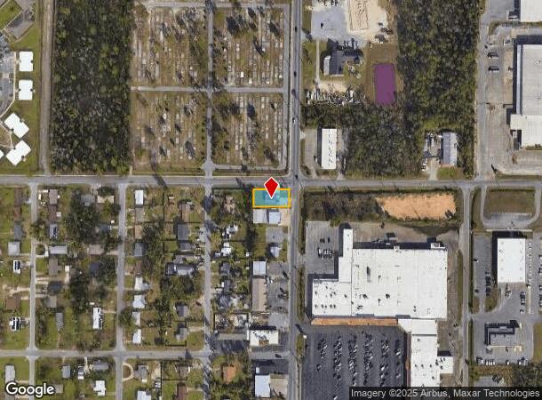
Nearby Places
Map Layers
Map Styles
 Street
 Aerial
- Restaurants
- Banks
- Shops
- Fitness
- Groceries
PUBLIC TRANSPORTATION
AIRPORT
Northwest Florida Beaches International
DRIVE
WALK
Distance
Northwest Florida Beaches International
38 min
23.1 mi
Freight Ports
Port of Panama City
DRIVE
WALK
Distance
Port of Panama City
7 min
3.5 mi
Nearby Properties
Address
Land Use
TOTAL SIZE
Lot Size
Zoning
Address
Land Use
TOTAL SIZE
Lot Size
Zoning
764,032 SF
12.80 AC
PC14
Address
Land Use
TOTAL SIZE
Lot Size
Zoning
477,423 SF
21.91 AC
PC09
Address
Land Use
TOTAL SIZE
Lot Size
Zoning
279,378 SF
13.24 AC
PC07
Address
Land Use
TOTAL SIZE
Lot Size
Zoning
648,279 SF
73.10 AC
PC14
Address
Land Use
TOTAL SIZE
Lot Size
Zoning
455,239 SF
11.87 AC
PC11
Address
Land Use
TOTAL SIZE
Lot Size
Zoning
214,953 SF
14.58 AC
PC09
Address
Land Use
TOTAL SIZE
Lot Size
Zoning
354,592 SF
24 AC
UND
Address
Land Use
TOTAL SIZE
Lot Size
Zoning
239,259 SF
15.86 AC
UND
Address
Land Use
TOTAL SIZE
Lot Size
Zoning
252,630 SF
10.70 AC
Address
Land Use
TOTAL SIZE
Lot Size
Zoning
503,491 SF
79.46 AC
PC12
Address
Land Use
TOTAL SIZE
Lot Size
Zoning
140,899 SF
15.48 AC
PC09
Address
Land Use
TOTAL SIZE
Lot Size
Zoning
86,629 SF
4.70 AC
Address
Land Use
TOTAL SIZE
Lot Size
Zoning
142,051 SF
13.43 AC
PC09
Address
Land Use
TOTAL SIZE
Lot Size
Zoning
208,296 SF
24.72 AC
PC05
Address
Land Use
TOTAL SIZE
Lot Size
Zoning
194,474 SF
16.03 AC
PC09
Address
Land Use
TOTAL SIZE
Lot Size
Zoning
Address
Land Use
TOTAL SIZE
Lot Size
Zoning
68,418 SF
443.51 AC
PC11
Address
Land Use
TOTAL SIZE
Lot Size
Zoning
115,056 SF
21 AC
PC09
Address
Land Use
TOTAL SIZE
Lot Size
Zoning
122,813 SF
9.58 AC
PC09
Address
Land Use
TOTAL SIZE
Lot Size
Zoning
Address
Land Use
TOTAL SIZE
Lot Size
Zoning
238,930 SF
39.18 AC
PSP
Address
Land Use
TOTAL SIZE
Lot Size
Zoning
207,286 SF
3.48 AC
PC10
Address
Land Use
TOTAL SIZE
Lot Size
Zoning
165,098 SF
9.67 AC
PC04
Address
Land Use
TOTAL SIZE
Lot Size
Zoning
81,774 SF
17.46 AC
PC05
Address
Land Use
TOTAL SIZE
Lot Size
Zoning
164,923 SF
23.60 AC
PC09
Address
Land Use
TOTAL SIZE
Lot Size
Zoning
118,302 SF
8 AC
PC05
Address
Land Use
TOTAL SIZE
Lot Size
Zoning
41,300 SF
17.87 AC
PC14
Address
Land Use
TOTAL SIZE
Lot Size
Zoning
256,570 SF
7 AC
PC14
Address
Land Use
TOTAL SIZE
Lot Size
Zoning
62,640 SF
0.48 AC
PC10
Address
Land Use
TOTAL SIZE
Lot Size
Zoning
154,028 SF
2.01 AC
PC10
The World's #1 Commercial Real Estate Marketplace
Connect with us
© 2026 CoStar Group
The information above has been obtained from sources believed reliable. While we do not doubt its accuracy we have not verified it and make no guarantee, warranty or representation about it. It is your responsibility to independently confirm its accuracy and completeness. Any projections, opinions, assumptions, or estimates used are for example only and do not represent the current or future performance of the property. The value of this transaction to you depends on tax and other factors which should be evaluated by your tax, financial, and legal advisors. You and your advisors should conduct a careful, independent investigation of the property to determine to your satisfaction the suitability of the property for your needs.