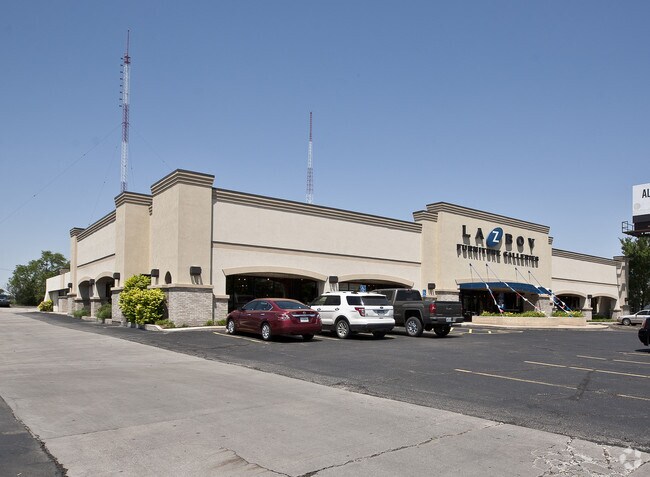
Property Record
1619 N Rock Rd, Mulvane, KS 67110
NEARBY LISTINGS FOR SALE OR LEASE
Property Detail
1619 N Rock Rd
Wichita, KS
North Rock Add
239-30-0-41-01-002.00A
BEG NE COR SE1/4 S 711.6 FT W 280 FT N 50 FT W 1045 FT M-L TO W LI E1/2 SE1/4 N TO NW COR E1/2 SE1/4 E TO BEG EXC N 389.97 FT E 389 FT EXC E 50 FT FOR RD & EXC W 300 FT E 1033.34 FT S 373 FT N 661.6 FT SE1/4 & EXC COMM NE COR SE 1/4 TH S 711.6 FT & W
Farms
Sedgwick
AE
Kansas
20173C0676G
5
2024
0.80 AC
2025
Northeast
009902
Wichita
1,160 SF
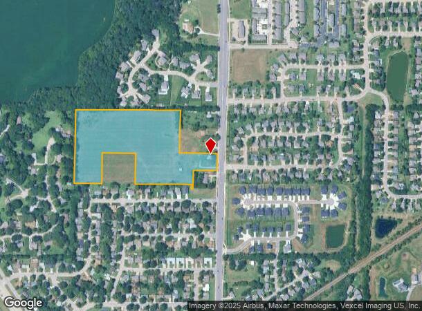
DEMOGRAPHICS near 1619 N Rock Rd
1 Mile
3 Mile
5 Mile
2024 Total Population
6,232
66,561
168,487
2029 Population
6,317
67,645
172,257
Pop Growth 2024-2029
+ 1.36%
+ 1.63%
+ 2.24%
Average Age
44
39
38
2024 Total Households
2,826
27,992
68,345
HH Growth 2024-2029
+ 1.24%
+ 1.54%
+ 2.18%
Median Household Inc
$65,754
$64,699
$59,269
Avg Household Size
2.10
2.20
2.30
2024 Avg HH Vehicles
2.00
2.00
2.00
Median Home Value
$293,341
$209,232
$180,208
Median Year Built
1979
1975
1974
Nearby Places
Map Layers
Map Styles
 Street
 Aerial
- Restaurants
- Banks
- Shops
- Fitness
- Groceries
PUBLIC TRANSPORTATION
AIRPORT
Wichita Dwight D Eisenhower Ntl
DRIVE
WALK
Distance
Wichita Dwight D Eisenhower Ntl
34 min
22.2 mi
Freight Ports
Tulsa Port Of Catoosa
DRIVE
WALK
Distance
Tulsa Port Of Catoosa
199 min
183.6 mi
Nearby Properties
Address
Land Use
TOTAL SIZE
Lot Size
Zoning
Address
Land Use
TOTAL SIZE
Lot Size
Zoning
138,281 SF
60.34 AC
Address
Land Use
TOTAL SIZE
Lot Size
Zoning
189,092 SF
35.98 AC
Address
Land Use
TOTAL SIZE
Lot Size
Zoning
127,266 SF
20.04 AC
Address
Land Use
TOTAL SIZE
Lot Size
Zoning
64,858 SF
11.39 AC
R1
Address
Land Use
TOTAL SIZE
Lot Size
Zoning
62,829 SF
7.15 AC
R1
Address
Land Use
TOTAL SIZE
Lot Size
Zoning
39,304 SF
2.80 AC
Address
Land Use
TOTAL SIZE
Lot Size
Zoning
35,032 SF
12.62 AC
I1
Address
Land Use
TOTAL SIZE
Lot Size
Zoning
14,026 SF
1.61 AC
Address
Land Use
TOTAL SIZE
Lot Size
Zoning
178,675 SF
Address
Land Use
TOTAL SIZE
Lot Size
Zoning
30,610 SF
3.46 AC
Address
Land Use
TOTAL SIZE
Lot Size
Zoning
28,000 SF
5.50 AC
Address
Land Use
TOTAL SIZE
Lot Size
Zoning
24,900 SF
4.30 AC
Address
Land Use
TOTAL SIZE
Lot Size
Zoning
9,567 SF
4.01 AC
Address
Land Use
TOTAL SIZE
Lot Size
Zoning
3,381 SF
56.91 AC
AA
Address
Land Use
TOTAL SIZE
Lot Size
Zoning
37.22 AC
R1
Address
Land Use
TOTAL SIZE
Lot Size
Zoning
17,548 SF
Address
Land Use
TOTAL SIZE
Lot Size
Zoning
17,047 SF
1.30 AC
Address
Land Use
TOTAL SIZE
Lot Size
Zoning
10,600 SF
4.90 AC
RR
Address
Land Use
TOTAL SIZE
Lot Size
Zoning
600 SF
Address
Land Use
TOTAL SIZE
Lot Size
Zoning
3,464 SF
1.90 AC
Address
Land Use
TOTAL SIZE
Lot Size
Zoning
14,095 SF
0.67 AC
Address
Land Use
TOTAL SIZE
Lot Size
Zoning
6,400 SF
5.34 AC
R1
Address
Land Use
TOTAL SIZE
Lot Size
Zoning
11,498 SF
1 AC
Address
Land Use
TOTAL SIZE
Lot Size
Zoning
4,290 SF
4.80 AC
Address
Land Use
TOTAL SIZE
Lot Size
Zoning
11,877 SF
4.39 AC
RR
Address
Land Use
TOTAL SIZE
Lot Size
Zoning
6,689 SF
2.90 AC
R1B
Address
Land Use
TOTAL SIZE
Lot Size
Zoning
4,254 SF
2.13 AC
R
Address
Land Use
TOTAL SIZE
Lot Size
Zoning
9,760 SF
3.55 AC
R1
Address
Land Use
TOTAL SIZE
Lot Size
Zoning
41,989 SF
6.18 AC
B3
Address
Land Use
TOTAL SIZE
Lot Size
Zoning
15,580 SF
4.91 AC
The World's #1 Commercial Real Estate Marketplace
Connect with us
© 2025 CoStar Group
The information above has been obtained from sources believed reliable. While we do not doubt its accuracy we have not verified it and make no guarantee, warranty or representation about it. It is your responsibility to independently confirm its accuracy and completeness. Any projections, opinions, assumptions, or estimates used are for example only and do not represent the current or future performance of the property. The value of this transaction to you depends on tax and other factors which should be evaluated by your tax, financial, and legal advisors. You and your advisors should conduct a careful, independent investigation of the property to determine to your satisfaction the suitability of the property for your needs.