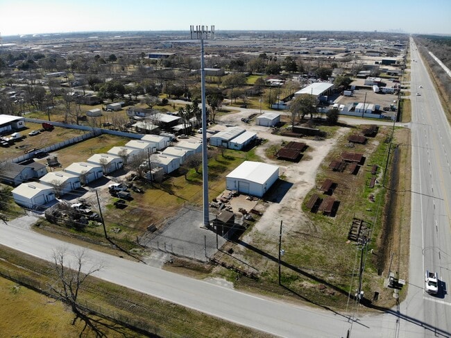
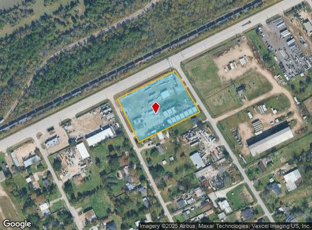
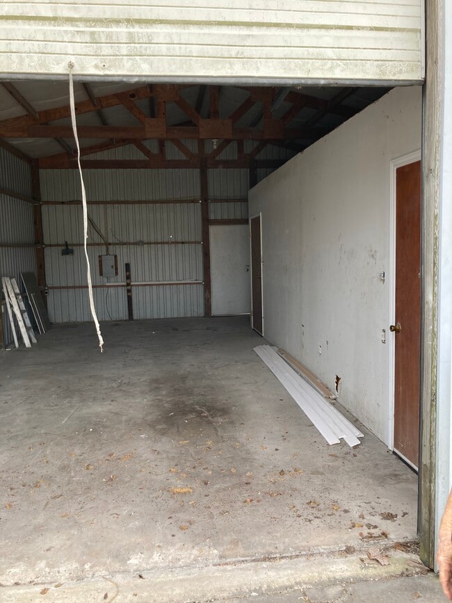
Property Record
16190 Beaumont Hwy, Houston, TX 77049

Current Lease Availabilities
NEARBY LISTINGS FOR SALE OR LEASE
Property Detail
16190 Beaumont Hwy
Houston-Pasadena-The Woodlands, TX
Sheldon Park
0731390010001
LTS 1 THRU 7 BLK 1 SHELDON PARK
Outdoorrecreationbeachmountaindesert
Harris
X
Texas
48201C0710M
1-7
2024
3.29 AC
2025
Northeast Hwy 90
252202
Houston
4,880 SF
DEMOGRAPHICS near 16190 Beaumont Hwy
1 Mile
3 Mile
5 Mile
2024 Total Population
1,734
19,716
111,963
2029 Population
1,662
20,264
114,109
Pop Growth 2024-2029
(4.15%)
+ 2.78%
+ 1.92%
Average Age
32
31
33
2024 Total Households
547
5,878
33,632
HH Growth 2024-2029
(4.39%)
+ 2.72%
+ 1.85%
Median Household Inc
$64,367
$63,247
$63,331
Avg Household Size
3.10
3.30
3.30
2024 Avg HH Vehicles
2.00
2.00
2.00
Median Home Value
$154,917
$171,967
$174,169
Median Year Built
1983
2006
1998
Nearby Places
Map Layers
Map Styles
 Street
 Aerial
- Restaurants
- Banks
- Shops
- Fitness
- Groceries
PUBLIC TRANSPORTATION
AIRPORT
George Bush Intcntl/Houston
DRIVE
WALK
Distance
George Bush Intcntl/Houston
27 min
19.2 mi
William P Hobby
DRIVE
WALK
Distance
William P Hobby
37 min
21.9 mi
Freight Ports
Port of Houston
DRIVE
WALK
Distance
Port of Houston
23 min
13.9 mi
Nearby Properties
Address
Land Use
TOTAL SIZE
Lot Size
Zoning
Address
Land Use
TOTAL SIZE
Lot Size
Zoning
409.44 AC
Address
Land Use
TOTAL SIZE
Lot Size
Zoning
1,421,980 SF
147.83 AC
Address
Land Use
TOTAL SIZE
Lot Size
Zoning
1,056.36 AC
Address
Land Use
TOTAL SIZE
Lot Size
Zoning
183.58 AC
Address
Land Use
TOTAL SIZE
Lot Size
Zoning
36.04 AC
Address
Land Use
TOTAL SIZE
Lot Size
Zoning
1,403,952 SF
48.81 AC
Address
Land Use
TOTAL SIZE
Lot Size
Zoning
263,162 SF
75.07 AC
Address
Land Use
TOTAL SIZE
Lot Size
Zoning
277,486 SF
15.42 AC
Address
Land Use
TOTAL SIZE
Lot Size
Zoning
434,978 SF
37.08 AC
Address
Land Use
TOTAL SIZE
Lot Size
Zoning
430,841 SF
193.79 AC
Address
Land Use
TOTAL SIZE
Lot Size
Zoning
225,124 SF
10.20 AC
Address
Land Use
TOTAL SIZE
Lot Size
Zoning
315,000 SF
21.47 AC
Address
Land Use
TOTAL SIZE
Lot Size
Zoning
212,558 SF
52.87 AC
Address
Land Use
TOTAL SIZE
Lot Size
Zoning
168,348 SF
108.41 AC
Address
Land Use
TOTAL SIZE
Lot Size
Zoning
330,927 SF
82.08 AC
Address
Land Use
TOTAL SIZE
Lot Size
Zoning
392.95 AC
Address
Land Use
TOTAL SIZE
Lot Size
Zoning
260,792 SF
206.39 AC
Address
Land Use
TOTAL SIZE
Lot Size
Zoning
537,768 SF
12.46 AC
Address
Land Use
TOTAL SIZE
Lot Size
Zoning
48.81 AC
Address
Land Use
TOTAL SIZE
Lot Size
Zoning
223,872 SF
Address
Land Use
TOTAL SIZE
Lot Size
Zoning
174,606 SF
55.34 AC
Address
Land Use
TOTAL SIZE
Lot Size
Zoning
296,173 SF
16.33 AC
Address
Land Use
TOTAL SIZE
Lot Size
Zoning
634,459 SF
469.92 AC
Address
Land Use
TOTAL SIZE
Lot Size
Zoning
392.95 AC
Address
Land Use
TOTAL SIZE
Lot Size
Zoning
158,856 SF
16.04 AC
Address
Land Use
TOTAL SIZE
Lot Size
Zoning
71,892 SF
82.98 AC
Address
Land Use
TOTAL SIZE
Lot Size
Zoning
113,290 SF
30.61 AC
Address
Land Use
TOTAL SIZE
Lot Size
Zoning
188,510 SF
80.78 AC
Address
Land Use
TOTAL SIZE
Lot Size
Zoning
63,079 SF
7.71 AC
Address
Land Use
TOTAL SIZE
Lot Size
Zoning
120,468 SF
37.05 AC
The World's #1 Commercial Real Estate Marketplace
Connect with us
© 2026 CoStar Group
The information above has been obtained from sources believed reliable. While we do not doubt its accuracy we have not verified it and make no guarantee, warranty or representation about it. It is your responsibility to independently confirm its accuracy and completeness. Any projections, opinions, assumptions, or estimates used are for example only and do not represent the current or future performance of the property. The value of this transaction to you depends on tax and other factors which should be evaluated by your tax, financial, and legal advisors. You and your advisors should conduct a careful, independent investigation of the property to determine to your satisfaction the suitability of the property for your needs.