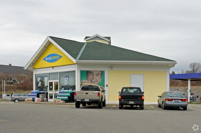
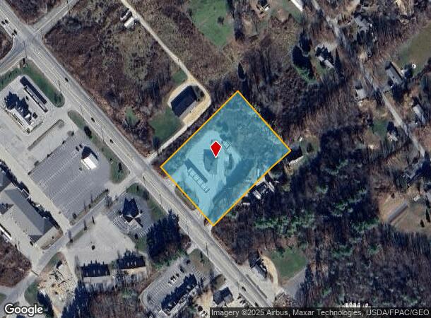
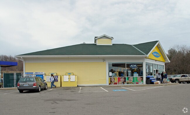
Property Record
162 Harold L Dow Hwy, Eliot, ME 03903
NEARBY LISTINGS FOR SALE OR LEASE
Property Detail
162 Harold L Dow Hwy
Gasolinefuelbulkstorage
York
X
Maine
23031C0645G
3.21 AC
2024
York County
2024
Portland/South Portland
037000
Portland-South Portland, ME
2,889 SF
ELIO-000029-000021
DEMOGRAPHICS near 162 Harold L Dow Hwy
1 Mile
3 Mile
5 Mile
2024 Total Population
1,253
11,440
40,299
2029 Population
1,311
11,997
42,249
Pop Growth 2024-2029
+ 4.63%
+ 4.87%
+ 4.84%
Average Age
45
45
44
2024 Total Households
522
5,032
18,032
HH Growth 2024-2029
+ 4.60%
+ 4.81%
+ 4.82%
Median Household Inc
$82,954
$84,218
$98,165
Avg Household Size
2.40
2.20
2.20
2024 Avg HH Vehicles
2.00
2.00
2.00
Median Home Value
$392,682
$400,823
$484,557
Median Year Built
1981
1981
1968
Nearby Places
Map Layers
Map Styles
 Street
 Aerial
- Restaurants
- Banks
- Shops
- Fitness
- Groceries
PUBLIC TRANSPORTATION
COMMUTER RAIL
DRIVE
WALK
Distance
17 min
8.3 mi
AIRPORT
Portsmouth International at Pease
DRIVE
WALK
Distance
Portsmouth International at Pease
14 min
7.0 mi
Freight Ports
Portland, ME
DRIVE
WALK
Distance
Portland, ME
62 min
51.1 mi
Nearby Properties
Address
Land Use
TOTAL SIZE
Lot Size
Zoning
Address
Land Use
TOTAL SIZE
Lot Size
Zoning
58.25 AC
COMM
Address
Land Use
TOTAL SIZE
Lot Size
Zoning
98.73 AC
C/I
Address
Land Use
TOTAL SIZE
Lot Size
Zoning
1,575 SF
52.95 AC
COMM
Address
Land Use
TOTAL SIZE
Lot Size
Zoning
22.33 AC
MU-N
Address
Land Use
TOTAL SIZE
Lot Size
Zoning
0.67 AC
VD
Address
Land Use
TOTAL SIZE
Lot Size
Zoning
11.30 AC
G1
Address
Land Use
TOTAL SIZE
Lot Size
Zoning
48.95 AC
WIND
Address
Land Use
TOTAL SIZE
Lot Size
Zoning
3.78 AC
COMM
Address
Land Use
TOTAL SIZE
Lot Size
Zoning
64.76 AC
WIND
Address
Land Use
TOTAL SIZE
Lot Size
Zoning
18.49 AC
GRB
Address
Land Use
TOTAL SIZE
Lot Size
Zoning
3.97 AC
SD
Address
Land Use
TOTAL SIZE
Lot Size
Zoning
84,273 SF
13.61 AC
C-1
Address
Land Use
TOTAL SIZE
Lot Size
Zoning
9,060 SF
7.02 AC
IND
Address
Land Use
TOTAL SIZE
Lot Size
Zoning
39,780 SF
8.82 AC
OR
Address
Land Use
TOTAL SIZE
Lot Size
Zoning
5.45 AC
OFF
Address
Land Use
TOTAL SIZE
Lot Size
Zoning
117,028 SF
12.25 AC
G1
Address
Land Use
TOTAL SIZE
Lot Size
Zoning
238,513 SF
31.02 AC
COMM
Address
Land Use
TOTAL SIZE
Lot Size
Zoning
81,964 SF
6.99 AC
OR
Address
Land Use
TOTAL SIZE
Lot Size
Zoning
40,736 SF
14.82 AC
C-1
Address
Land Use
TOTAL SIZE
Lot Size
Zoning
101,643 SF
8.41 AC
OFF
Address
Land Use
TOTAL SIZE
Lot Size
Zoning
92,943 SF
8.55 AC
C-1
Address
Land Use
TOTAL SIZE
Lot Size
Zoning
201,109 SF
35.12 AC
WI
Address
Land Use
TOTAL SIZE
Lot Size
Zoning
10.78 AC
GRB
Address
Land Use
TOTAL SIZE
Lot Size
Zoning
275,051 SF
19.38 AC
COMM
Address
Land Use
TOTAL SIZE
Lot Size
Zoning
6.82 AC
GRB
Address
Land Use
TOTAL SIZE
Lot Size
Zoning
131,171 SF
13.91 AC
COMM
Address
Land Use
TOTAL SIZE
Lot Size
Zoning
88,630 SF
5.50 AC
R-S
Address
Land Use
TOTAL SIZE
Lot Size
Zoning
49,480 SF
5.62 AC
OR
Address
Land Use
TOTAL SIZE
Lot Size
Zoning
84,855 SF
8 AC
COMM
Address
Land Use
TOTAL SIZE
Lot Size
Zoning
117,164 SF
5.40 AC
C-3
The World's #1 Commercial Real Estate Marketplace
Connect with us
© 2025 CoStar Group
The information above has been obtained from sources believed reliable. While we do not doubt its accuracy we have not verified it and make no guarantee, warranty or representation about it. It is your responsibility to independently confirm its accuracy and completeness. Any projections, opinions, assumptions, or estimates used are for example only and do not represent the current or future performance of the property. The value of this transaction to you depends on tax and other factors which should be evaluated by your tax, financial, and legal advisors. You and your advisors should conduct a careful, independent investigation of the property to determine to your satisfaction the suitability of the property for your needs.