Property Record
119 W 100 S, Rupert, ID 83350
NEARBY LISTINGS FOR SALE OR LEASE
-
-
View all Rupert listings for sale on LoopNet.com
Property Detail
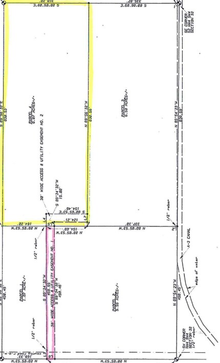
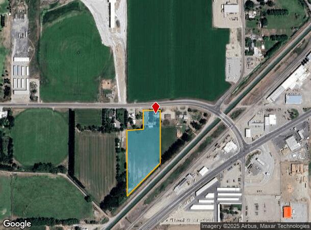
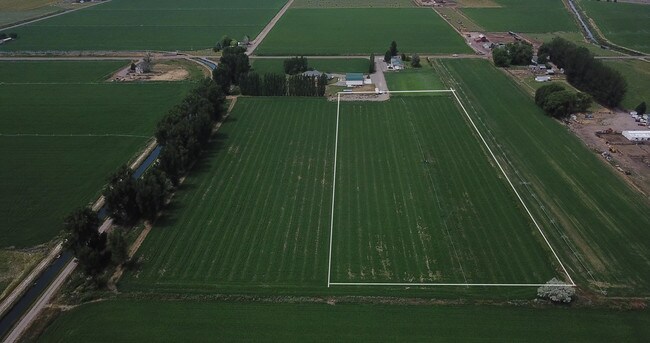
119 W 100 S
Burley, ID
TAX 31, 44 & 1220 IN LOT 6 31-9-24
RP09S24E310185
Minidoka
Ruralimprovednonresidential
Idaho
2025
6
2025
5.72 AC
970400
Idaho South Area
3,310 SF
Other Market Areas
DEMOGRAPHICS near 119 W 100 S
1 Mile
3 Mile
5 Mile
2024 Total Population
1,408
9,678
15,824
2029 Population
1,545
10,547
17,157
Pop Growth 2024-2029
+ 9.73%
+ 8.98%
+ 8.42%
Average Age
38
37
37
2024 Total Households
500
3,458
5,641
HH Growth 2024-2029
+ 9.60%
+ 8.85%
+ 8.30%
Median Household Inc
$53,500
$55,020
$56,992
Avg Household Size
2.80
2.80
2.80
2024 Avg HH Vehicles
2.00
2.00
2.00
Median Home Value
$142,366
$162,639
$192,200
Median Year Built
1973
1971
1973
Nearby Places
Map Layers
Map Styles
 Street
 Aerial
- Restaurants
- Banks
- Shops
- Fitness
- Groceries
SALE & LEASE HISTORY
LISTING DATE
SALE/LEASE

Oct 18, 2019
For Sale
Nearby Properties
Address
Land Use
TOTAL SIZE
Lot Size
Zoning
Address
Land Use
TOTAL SIZE
Lot Size
Zoning
31,500 SF
17.44 AC
Address
Land Use
TOTAL SIZE
Lot Size
Zoning
6.48 AC
Address
Land Use
TOTAL SIZE
Lot Size
Zoning
12.13 AC
Address
Land Use
TOTAL SIZE
Lot Size
Zoning
10.71 AC
Address
Land Use
TOTAL SIZE
Lot Size
Zoning
9.95 AC
4
Address
Land Use
TOTAL SIZE
Lot Size
Zoning
9.43 AC
Address
Land Use
TOTAL SIZE
Lot Size
Zoning
13,586 SF
11.36 AC
Address
Land Use
TOTAL SIZE
Lot Size
Zoning
30,080 SF
2.60 AC
4
Address
Land Use
TOTAL SIZE
Lot Size
Zoning
35,802 SF
0.72 AC
4
Address
Land Use
TOTAL SIZE
Lot Size
Zoning
8.16 AC
Address
Land Use
TOTAL SIZE
Lot Size
Zoning
12,650 SF
5.90 AC
4
Address
Land Use
TOTAL SIZE
Lot Size
Zoning
18,000 SF
3.78 AC
Address
Land Use
TOTAL SIZE
Lot Size
Zoning
44,588 SF
4.91 AC
4
Address
Land Use
TOTAL SIZE
Lot Size
Zoning
14,000 SF
2.98 AC
4
Address
Land Use
TOTAL SIZE
Lot Size
Zoning
15,560 SF
3.06 AC
Address
Land Use
TOTAL SIZE
Lot Size
Zoning
24,600 SF
6.77 AC
Address
Land Use
TOTAL SIZE
Lot Size
Zoning
3,750 SF
33.30 AC
4
Address
Land Use
TOTAL SIZE
Lot Size
Zoning
1.39 AC
Address
Land Use
TOTAL SIZE
Lot Size
Zoning
4,118 SF
2.66 AC
Address
Land Use
TOTAL SIZE
Lot Size
Zoning
21,900 SF
1.22 AC
Address
Land Use
TOTAL SIZE
Lot Size
Zoning
12,720 SF
0.99 AC
4
Address
Land Use
TOTAL SIZE
Lot Size
Zoning
17,655 SF
8.27 AC
Address
Land Use
TOTAL SIZE
Lot Size
Zoning
11,577 SF
76.74 AC
Address
Land Use
TOTAL SIZE
Lot Size
Zoning
17.43 AC
Address
Land Use
TOTAL SIZE
Lot Size
Zoning
8,487 SF
3.72 AC
Address
Land Use
TOTAL SIZE
Lot Size
Zoning
15,211 SF
5 AC
Address
Land Use
TOTAL SIZE
Lot Size
Zoning
15,661 SF
2.51 AC
Address
Land Use
TOTAL SIZE
Lot Size
Zoning
8,800 SF
0.48 AC
4
Address
Land Use
TOTAL SIZE
Lot Size
Zoning
10,560 SF
4.63 AC
Address
Land Use
TOTAL SIZE
Lot Size
Zoning
6,788 SF
1.91 AC
The World's #1 Commercial Real Estate Marketplace
Connect with us
© 2025 CoStar Group
The information above has been obtained from sources believed reliable. While we do not doubt its accuracy we have not verified it and make no guarantee, warranty or representation about it. It is your responsibility to independently confirm its accuracy and completeness. Any projections, opinions, assumptions, or estimates used are for example only and do not represent the current or future performance of the property. The value of this transaction to you depends on tax and other factors which should be evaluated by your tax, financial, and legal advisors. You and your advisors should conduct a careful, independent investigation of the property to determine to your satisfaction the suitability of the property for your needs.