Property Record
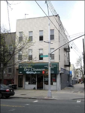
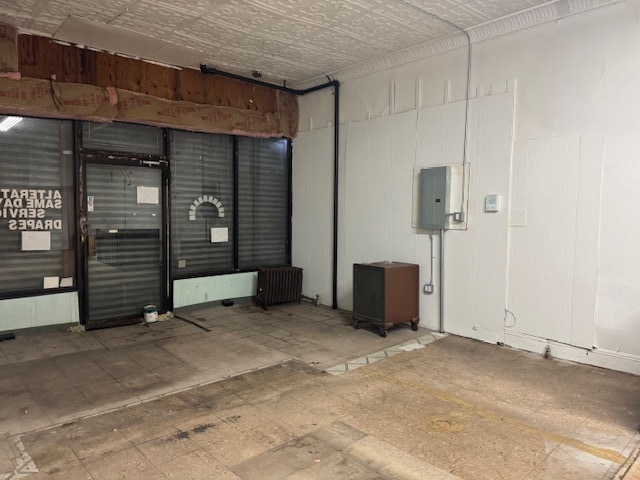
162 Saint Nicholas Ave, Brooklyn, NY 11237


NEARBY LISTINGS FOR SALE OR LEASE
Property Detail
162 Saint Nicholas Ave
03271-0025
DOCID-2017122600039001
Commercialofficeresidentialmixeduse
Kings
X
New York
3604970208F
25
2024
0.05 AC
2025
Bushwick
044300
Long Island (New York)
4,500 SF
New York-Jersey City-White Plains, NY-NJ
DEMOGRAPHICS near 162 Saint Nicholas Ave
1 mile
3 mile
5 mile
2024 Total Population
136,800
1,041,375
3,137,750
2029 Population
127,155
976,774
2,942,036
Pop Growth 2024-2029
(7.05%)
(6.20%)
(6.24%)
Average Age
36
37
39
2024 Total Households
48,913
387,273
1,261,789
HH Growth 2024-2029
(7.58%)
(6.62%)
(6.45%)
Median Household Inc
$71,584
$68,955
$80,103
Avg Household Size
2.70
2.60
2.40
2024 Avg HH Vehicles
.00
1.00
.00
Median Home Value
$876,605
$821,385
$803,694
Median Year Built
1947
1948
1949
Nearby Places
Map Layers
Map Styles
 Street
 Aerial
Transit
 Traffic
 Biking
Places
Listings with unknown addresses are not visible on the map
- Restaurants
- Banks
- Shops
- Fitness
- Groceries
PUBLIC TRANSPORTATION
TRANSIT/SUBWAY
DeKalb Avenue (L Line) (L - New York MTA Subway (The Subway))
Drive
Walk
Distance
DeKalb Avenue (L Line) (L - New York MTA Subway (The Subway))
1 min
3 min
0.2 mi
Jefferson Street (L - New York MTA Subway (The Subway))
Drive
Walk
Distance
Jefferson Street (L - New York MTA Subway (The Subway))
2 min
9 min
0.4 mi
Myrtle-Wyckoff Avenues (L - New York MTA Subway (The Subway), M - New York MTA Subway (The Subway))
Drive
Walk
Distance
Myrtle-Wyckoff Avenues (L - New York MTA Subway (The Subway), M - New York MTA Subway (The Subway))
2 min
9 min
0.5 mi
Knickerbocker Avenue (M Line) (M - New York MTA Subway (The Subway))
Drive
Walk
Distance
Knickerbocker Avenue (M Line) (M - New York MTA Subway (The Subway))
2 min
10 min
0.5 mi
Seneca Avenue (M - New York MTA Subway (The Subway))
Drive
Walk
Distance
Seneca Avenue (M - New York MTA Subway (The Subway))
2 min
12 min
0.6 mi
COMMUTER RAIL
East New York Station (Far Rockaway Branch - Long Island Rail Road, Long Beach Branch - Long Island Rail Road, West Hempstead Branch - Long Island Rail Road)
Drive
Walk
Distance
East New York Station (Far Rockaway Branch - Long Island Rail Road, Long Beach Branch - Long Island Rail Road, West Hempstead Branch - Long Island Rail Road)
8 min
3.0 mi
Nostrand Avenue Station (Far Rockaway Branch - Long Island Rail Road, Hempstead Branch - Long Island Rail Road, Long Beach Branch - Long Island Rail Road, West Hempstead Branch - Long Island Rail Road)
Drive
Walk
Distance
Nostrand Avenue Station (Far Rockaway Branch - Long Island Rail Road, Hempstead Branch - Long Island Rail Road, Long Beach Branch - Long Island Rail Road, West Hempstead Branch - Long Island Rail Road)
11 min
3.4 mi
AIRPORT
LaGuardia
Drive
Walk
Distance
LaGuardia
15 min
6.7 mi
John F Kennedy International
Drive
Walk
Distance
John F Kennedy International
19 min
11.1 mi
Newark Liberty International
Drive
Walk
Distance
Newark Liberty International
33 min
17.2 mi
Freight Ports
NY - Red Hook Container Terminal
Drive
Walk
Distance
NY - Red Hook Container Terminal
15 min
6.2 mi
SALE & LEASE HISTORY
LISTING DATE
SALE/LEASE

Sep 24, 2025
For Lease
Nearby Properties
Address
Land Use
TOTAL SIZE
Lot Size
Zoning
Address
Land Use
TOTAL SIZE
Lot Size
Zoning
2,812,739 SF
2.10 AC
C5-3
Address
Land Use
TOTAL SIZE
Lot Size
Zoning
7,058,736 SF
147.61 AC
M3-1
Address
Land Use
TOTAL SIZE
Lot Size
Zoning
445,151 SF
C6-4
Address
Land Use
TOTAL SIZE
Lot Size
Zoning
445,151 SF
C6-4
Address
Land Use
TOTAL SIZE
Lot Size
Zoning
835,231 SF
11.32 AC
R6
Address
Land Use
TOTAL SIZE
Lot Size
Zoning
512,755 SF
1.19 AC
R6
Address
Land Use
TOTAL SIZE
Lot Size
Zoning
503,608 SF
1.64 AC
R8
Address
Land Use
TOTAL SIZE
Lot Size
Zoning
777,258 SF
4.67 AC
M3-2
Address
Land Use
TOTAL SIZE
Lot Size
Zoning
582,700 SF
1.20 AC
R8
Address
Land Use
TOTAL SIZE
Lot Size
Zoning
863,800 SF
2.71 AC
M1-4
Address
Land Use
TOTAL SIZE
Lot Size
Zoning
493,889 SF
1.84 AC
R7-3
Address
Land Use
TOTAL SIZE
Lot Size
Zoning
264,691 SF
5.17 AC
M1-2
Address
Land Use
TOTAL SIZE
Lot Size
Zoning
1,119,826 SF
2.76 AC
M1-4
Address
Land Use
TOTAL SIZE
Lot Size
Zoning
1,000 SF
210.07 AC
R3-2
Address
Land Use
TOTAL SIZE
Lot Size
Zoning
1,572,198 SF
22.06 AC
M1-2
Address
Land Use
TOTAL SIZE
Lot Size
Zoning
368,870 SF
0.73 AC
R8
Address
Land Use
TOTAL SIZE
Lot Size
Zoning
445,151 SF
C6-4
Address
Land Use
TOTAL SIZE
Lot Size
Zoning
826,915 SF
8.83 AC
M3-1
Address
Land Use
TOTAL SIZE
Lot Size
Zoning
446,763 SF
12.52 AC
R6
Address
Land Use
TOTAL SIZE
Lot Size
Zoning
1,150,500 SF
15.17 AC
R6
Address
Land Use
TOTAL SIZE
Lot Size
Zoning
363,205 SF
1.38 AC
M12R7A
Address
Land Use
TOTAL SIZE
Lot Size
Zoning
894,000 SF
4.14 AC
R6
Address
Land Use
TOTAL SIZE
Lot Size
Zoning
894,000 SF
4.14 AC
R6
Address
Land Use
TOTAL SIZE
Lot Size
Zoning
894,000 SF
4.14 AC
R6
Address
Land Use
TOTAL SIZE
Lot Size
Zoning
894,000 SF
4.14 AC
R6
Address
Land Use
TOTAL SIZE
Lot Size
Zoning
894,000 SF
4.14 AC
R6
Address
Land Use
TOTAL SIZE
Lot Size
Zoning
555,920 SF
2.61 AC
M1-2
Address
Land Use
TOTAL SIZE
Lot Size
Zoning
721,672 SF
6.56 AC
R6
Address
Land Use
TOTAL SIZE
Lot Size
Zoning
721,672 SF
6.56 AC
R6
Address
Land Use
TOTAL SIZE
Lot Size
Zoning
721,672 SF
6.56 AC
R6
The World's #1 Commercial Real Estate Marketplace
Connect with us
© 2026 CoStar Group
The information above has been obtained from sources believed reliable. While we do not doubt its accuracy we have not verified it and make no guarantee, warranty or representation about it. It is your responsibility to independently confirm its accuracy and completeness. Any projections, opinions, assumptions, or estimates used are for example only and do not represent the current or future performance of the property. The value of this transaction to you depends on tax and other factors which should be evaluated by your tax, financial, and legal advisors. You and your advisors should conduct a careful, independent investigation of the property to determine to your satisfaction the suitability of the property for your needs.