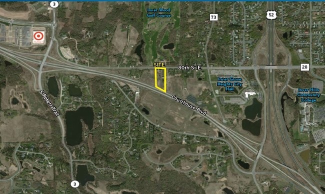
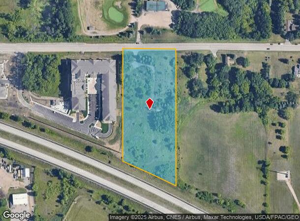
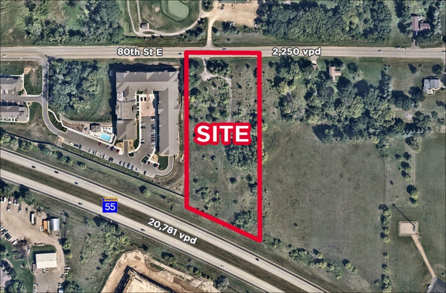
Property Record
1620 80Th St E, Inver Grove Heights, MN 55077
NEARBY LISTINGS FOR SALE OR LEASE
Property Detail
1620 80Th St E
20-01700-05-014
27 27 22 W 300.22 FT OF E 820 FT OF W 1/2 OF NE 1/4 LYING N OF N R/W STH #52-55 SUBJ TO CITY ST ESMNT OVER N 50 FT EX PAR 202 MN DOT R/W PLAT 19-111 SECTION 17 TWN 27 RANGE 22
Apartment
Dakota
X
Minnesota
27037C0105E
14
2024
4.86 AC
2024
Dakota County Outlying
060505
Minneapolis/St Paul
1,556 SF
Minneapolis-St. Paul-Bloomington, MN-WI
DEMOGRAPHICS near 1620 80Th St E
1 Mile
3 Mile
5 Mile
2024 Total Population
2,515
39,417
114,451
2029 Population
2,620
40,161
117,635
Pop Growth 2024-2029
+ 4.17%
+ 1.89%
+ 2.78%
Average Age
41
41
40
2024 Total Households
883
15,209
46,008
HH Growth 2024-2029
+ 3.96%
+ 1.78%
+ 2.80%
Median Household Inc
$113,758
$98,992
$87,655
Avg Household Size
2.70
2.50
2.40
2024 Avg HH Vehicles
2.00
2.00
2.00
Median Home Value
$431,176
$365,075
$334,929
Median Year Built
1994
1990
1984
Nearby Places
Map Layers
Map Styles
 Street
 Aerial
- Restaurants
- Banks
- Shops
- Fitness
- Groceries
PUBLIC TRANSPORTATION
COMMUTER RAIL
DRIVE
WALK
Distance
16 min
9.9 mi
AIRPORT
Minneapolis-St Paul International/Wold-Chamberlain
DRIVE
WALK
Distance
Minneapolis-St Paul International/Wold-Chamberlain
19 min
10.7 mi
SALE & LEASE HISTORY
LISTING DATE
SALE/LEASE

Sep 24, 2016
For Sale
Nearby Properties
Address
Land Use
TOTAL SIZE
Lot Size
Zoning
Address
Land Use
TOTAL SIZE
Lot Size
Zoning
479,742 SF
11.35 AC
Address
Land Use
TOTAL SIZE
Lot Size
Zoning
146,085 SF
46.83 AC
Address
Land Use
TOTAL SIZE
Lot Size
Zoning
Address
Land Use
TOTAL SIZE
Lot Size
Zoning
293,970 SF
31.92 AC
Address
Land Use
TOTAL SIZE
Lot Size
Zoning
223,583 SF
5.32 AC
Address
Land Use
TOTAL SIZE
Lot Size
Zoning
381,158 SF
11.86 AC
Address
Land Use
TOTAL SIZE
Lot Size
Zoning
317,235 SF
32.38 AC
Address
Land Use
TOTAL SIZE
Lot Size
Zoning
605,774 SF
44.50 AC
Address
Land Use
TOTAL SIZE
Lot Size
Zoning
228,810 SF
6.30 AC
Address
Land Use
TOTAL SIZE
Lot Size
Zoning
Address
Land Use
TOTAL SIZE
Lot Size
Zoning
212,331 SF
9.27 AC
Address
Land Use
TOTAL SIZE
Lot Size
Zoning
163,985 SF
7.06 AC
Address
Land Use
TOTAL SIZE
Lot Size
Zoning
1,339,582 SF
78.22 AC
Address
Land Use
TOTAL SIZE
Lot Size
Zoning
541,075 SF
88.93 AC
Address
Land Use
TOTAL SIZE
Lot Size
Zoning
206,503 SF
5.61 AC
Address
Land Use
TOTAL SIZE
Lot Size
Zoning
482,008 SF
23.78 AC
Address
Land Use
TOTAL SIZE
Lot Size
Zoning
138,609 SF
3.76 AC
Address
Land Use
TOTAL SIZE
Lot Size
Zoning
78,700 SF
6.12 AC
Address
Land Use
TOTAL SIZE
Lot Size
Zoning
Address
Land Use
TOTAL SIZE
Lot Size
Zoning
41,040 SF
11.38 AC
Address
Land Use
TOTAL SIZE
Lot Size
Zoning
150,469 SF
10.73 AC
Address
Land Use
TOTAL SIZE
Lot Size
Zoning
152,098 SF
8.23 AC
Address
Land Use
TOTAL SIZE
Lot Size
Zoning
28,461 SF
16.13 AC
Address
Land Use
TOTAL SIZE
Lot Size
Zoning
128,798 SF
4.22 AC
Address
Land Use
TOTAL SIZE
Lot Size
Zoning
150,900 SF
10.73 AC
Address
Land Use
TOTAL SIZE
Lot Size
Zoning
135,551 SF
15.01 AC
Address
Land Use
TOTAL SIZE
Lot Size
Zoning
358,532 SF
17.36 AC
Address
Land Use
TOTAL SIZE
Lot Size
Zoning
174,678 SF
24.36 AC
Address
Land Use
TOTAL SIZE
Lot Size
Zoning
135,959 SF
16.72 AC
The World's #1 Commercial Real Estate Marketplace
Connect with us
© 2025 CoStar Group
The information above has been obtained from sources believed reliable. While we do not doubt its accuracy we have not verified it and make no guarantee, warranty or representation about it. It is your responsibility to independently confirm its accuracy and completeness. Any projections, opinions, assumptions, or estimates used are for example only and do not represent the current or future performance of the property. The value of this transaction to you depends on tax and other factors which should be evaluated by your tax, financial, and legal advisors. You and your advisors should conduct a careful, independent investigation of the property to determine to your satisfaction the suitability of the property for your needs.