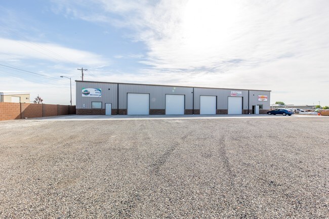
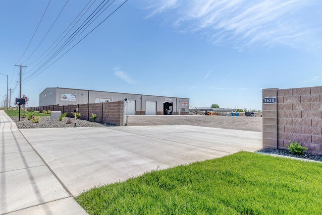
Property Record
1620 E Salt Lake St, Pasco, WA 99301

NEARBY LISTINGS FOR SALE OR LEASE
Property Detail
1620 E Salt Lake St
Other Market Areas
Freys Addn
Kennewick-Richland, WA
FREYS ADDN LOT 1 THRU 12, BLK 16 TOG W/10 OF VAC ALLEY, 10 VAC SALT LAKE ST & 40 VAC MONTANA ST
113-502-079
Franklin
Industrialgeneral
Washington
2025
1-12
2025
1.41 AC
020102
Yakima/Kennewick
11,600 SF
DEMOGRAPHICS near 1620 E Salt Lake St
1 Mile
3 Mile
5 Mile
2024 Total Population
10,140
37,952
100,171
2029 Population
11,013
41,090
107,942
Pop Growth 2024-2029
+ 8.61%
+ 8.27%
+ 7.76%
Average Age
31
33
35
2024 Total Households
2,746
10,927
32,087
HH Growth 2024-2029
+ 8.67%
+ 8.29%
+ 7.73%
Median Household Inc
$62,860
$59,960
$66,634
Avg Household Size
3.60
3.30
3.00
2024 Avg HH Vehicles
2.00
2.00
2.00
Median Home Value
$166,836
$180,124
$275,720
Median Year Built
1979
1970
1975
Nearby Places
Map Layers
Map Styles
 Street
 Aerial
- Restaurants
- Banks
- Shops
- Fitness
- Groceries
PUBLIC TRANSPORTATION
COMMUTER RAIL
Pasco Amtrak Station (Empire Builder - Amtrak)
DRIVE
WALK
Distance
Pasco Amtrak Station (Empire Builder - Amtrak)
4 min
1.7 mi
AIRPORT
Tri-Cities
DRIVE
WALK
Distance
Tri-Cities
7 min
3.8 mi
Freight Ports
Port of Tacoma
DRIVE
WALK
Distance
Port of Tacoma
274 min
239.5 mi
SALE & LEASE HISTORY
LISTING DATE
SALE/LEASE

May 22, 2017
For Sale
Apr 12, 2018
For Sale
Nearby Properties
Address
Land Use
TOTAL SIZE
Lot Size
Zoning
Address
Land Use
TOTAL SIZE
Lot Size
Zoning
1,078,419 SF
114.48 AC
Address
Land Use
TOTAL SIZE
Lot Size
Zoning
1,049,518 SF
104.40 AC
Address
Land Use
TOTAL SIZE
Lot Size
Zoning
277,478 SF
27.86 AC
Address
Land Use
TOTAL SIZE
Lot Size
Zoning
53,980 SF
25.90 AC
Address
Land Use
TOTAL SIZE
Lot Size
Zoning
2,863,808 SF
28.33 AC
Address
Land Use
TOTAL SIZE
Lot Size
Zoning
375,317 SF
17.68 AC
Address
Land Use
TOTAL SIZE
Lot Size
Zoning
189,054 SF
28.48 AC
Address
Land Use
TOTAL SIZE
Lot Size
Zoning
444,084 SF
58 AC
Address
Land Use
TOTAL SIZE
Lot Size
Zoning
204,680 SF
39.50 AC
Address
Land Use
TOTAL SIZE
Lot Size
Zoning
161,465 SF
24.12 AC
Address
Land Use
TOTAL SIZE
Lot Size
Zoning
214,102 SF
9.88 AC
Address
Land Use
TOTAL SIZE
Lot Size
Zoning
163,900 SF
11.90 AC
Address
Land Use
TOTAL SIZE
Lot Size
Zoning
140,275 SF
6.36 AC
Address
Land Use
TOTAL SIZE
Lot Size
Zoning
153,320 SF
7.37 AC
Address
Land Use
TOTAL SIZE
Lot Size
Zoning
35,284 SF
30.53 AC
Address
Land Use
TOTAL SIZE
Lot Size
Zoning
114,673 SF
6.58 AC
Address
Land Use
TOTAL SIZE
Lot Size
Zoning
84,951 SF
4.39 AC
Address
Land Use
TOTAL SIZE
Lot Size
Zoning
64,936 SF
Address
Land Use
TOTAL SIZE
Lot Size
Zoning
84,680 SF
3 AC
Address
Land Use
TOTAL SIZE
Lot Size
Zoning
67,635 SF
5.95 AC
Address
Land Use
TOTAL SIZE
Lot Size
Zoning
241,912 SF
12.99 AC
Address
Land Use
TOTAL SIZE
Lot Size
Zoning
584,810 SF
Address
Land Use
TOTAL SIZE
Lot Size
Zoning
20,919 SF
58.49 AC
KENNEWICK
Address
Land Use
TOTAL SIZE
Lot Size
Zoning
88,510 SF
14.04 AC
Address
Land Use
TOTAL SIZE
Lot Size
Zoning
103,750 SF
14.97 AC
Address
Land Use
TOTAL SIZE
Lot Size
Zoning
58,701 SF
11.34 AC
Address
Land Use
TOTAL SIZE
Lot Size
Zoning
80,604 SF
4.30 AC
Address
Land Use
TOTAL SIZE
Lot Size
Zoning
75,542 SF
6.36 AC
Address
Land Use
TOTAL SIZE
Lot Size
Zoning
125,508 SF
3.49 AC
Address
Land Use
TOTAL SIZE
Lot Size
Zoning
110,458 SF
20 AC
The World's #1 Commercial Real Estate Marketplace
Connect with us
© 2026 CoStar Group
The information above has been obtained from sources believed reliable. While we do not doubt its accuracy we have not verified it and make no guarantee, warranty or representation about it. It is your responsibility to independently confirm its accuracy and completeness. Any projections, opinions, assumptions, or estimates used are for example only and do not represent the current or future performance of the property. The value of this transaction to you depends on tax and other factors which should be evaluated by your tax, financial, and legal advisors. You and your advisors should conduct a careful, independent investigation of the property to determine to your satisfaction the suitability of the property for your needs.