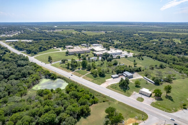
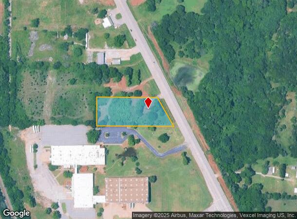
Property Record
1620 N Main St, Noble, OK 73068

NEARBY LISTINGS FOR SALE OR LEASE
Property Detail
1620 N Main St
Oklahoma City, OK
Cleveland
R0136523
Oklahoma
Sfr
2 AC
X
Outlying Cleveland County
40027C0295J
Oklahoma City
1,344 SF
DEMOGRAPHICS near 1620 N Main St
1 Mile
3 Mile
5 Mile
2024 Total Population
2,788
25,702
76,505
2029 Population
2,874
26,900
80,136
Pop Growth 2024-2029
+ 3.08%
+ 4.66%
+ 4.75%
Average Age
36
34
34
2024 Total Households
1,227
10,454
29,509
HH Growth 2024-2029
+ 2.85%
+ 4.74%
+ 5.10%
Median Household Inc
$55,499
$52,449
$48,101
Avg Household Size
2.20
2.30
2.20
2024 Avg HH Vehicles
2.00
2.00
2.00
Median Home Value
$197,336
$183,974
$193,506
Median Year Built
2001
1999
1987
Nearby Places
Map Layers
Map Styles
 Street
 Aerial
- Restaurants
- Banks
- Shops
- Fitness
- Groceries
PUBLIC TRANSPORTATION
COMMUTER RAIL
Norman Amtrak Station (Heartland Flyer - Amtrak)
DRIVE
WALK
Distance
Norman Amtrak Station (Heartland Flyer - Amtrak)
10 min
5.0 mi
AIRPORT
Will Rogers World
DRIVE
WALK
Distance
Will Rogers World
43 min
27.9 mi
Freight Ports
Tulsa Port Of Catoosa
DRIVE
WALK
Distance
Tulsa Port Of Catoosa
165 min
147.2 mi
SALE & LEASE HISTORY
LISTING DATE
SALE/LEASE

Sep 24, 2016
For Sale
Sep 22, 2025
For Sale
Dec 03, 2020
For Sale
Nearby Properties
Address
Land Use
TOTAL SIZE
Lot Size
Zoning
Address
Land Use
TOTAL SIZE
Lot Size
Zoning
200,000 SF
40 AC
Address
Land Use
TOTAL SIZE
Lot Size
Zoning
18.55 AC
Address
Land Use
TOTAL SIZE
Lot Size
Zoning
30.44 AC
Address
Land Use
TOTAL SIZE
Lot Size
Zoning
3.07 AC
Address
Land Use
TOTAL SIZE
Lot Size
Zoning
2.76 AC
Address
Land Use
TOTAL SIZE
Lot Size
Zoning
21,641 SF
5.11 AC
Address
Land Use
TOTAL SIZE
Lot Size
Zoning
345,756 SF
26.21 AC
Address
Land Use
TOTAL SIZE
Lot Size
Zoning
0.24 AC
Address
Land Use
TOTAL SIZE
Lot Size
Zoning
131,387 SF
9.55 AC
Address
Land Use
TOTAL SIZE
Lot Size
Zoning
54,160 SF
8.26 AC
Address
Land Use
TOTAL SIZE
Lot Size
Zoning
Address
Land Use
TOTAL SIZE
Lot Size
Zoning
467,281 SF
33.50 AC
Address
Land Use
TOTAL SIZE
Lot Size
Zoning
351,466 SF
67.68 AC
I2
Address
Land Use
TOTAL SIZE
Lot Size
Zoning
367,145 SF
22.97 AC
Address
Land Use
TOTAL SIZE
Lot Size
Zoning
4.36 AC
Address
Land Use
TOTAL SIZE
Lot Size
Zoning
1,170 SF
11.36 AC
R1
Address
Land Use
TOTAL SIZE
Lot Size
Zoning
40.63 AC
Address
Land Use
TOTAL SIZE
Lot Size
Zoning
9.33 AC
Address
Land Use
TOTAL SIZE
Lot Size
Zoning
298,423 SF
30.22 AC
Address
Land Use
TOTAL SIZE
Lot Size
Zoning
42,094 SF
18.75 AC
Address
Land Use
TOTAL SIZE
Lot Size
Zoning
308,059 SF
16.64 AC
Address
Land Use
TOTAL SIZE
Lot Size
Zoning
107,526 SF
18.77 AC
Address
Land Use
TOTAL SIZE
Lot Size
Zoning
46,824 SF
1.45 AC
Address
Land Use
TOTAL SIZE
Lot Size
Zoning
384 SF
26.92 AC
PU
Address
Land Use
TOTAL SIZE
Lot Size
Zoning
234,051 SF
80.33 AC
Address
Land Use
TOTAL SIZE
Lot Size
Zoning
189,564 SF
20.33 AC
Address
Land Use
TOTAL SIZE
Lot Size
Zoning
2.76 AC
Address
Land Use
TOTAL SIZE
Lot Size
Zoning
147,692 SF
16.19 AC
Address
Land Use
TOTAL SIZE
Lot Size
Zoning
184,949 SF
11.56 AC
Address
Land Use
TOTAL SIZE
Lot Size
Zoning
4,706 SF
11.03 AC
RM
The World's #1 Commercial Real Estate Marketplace
Connect with us
© 2025 CoStar Group
The information above has been obtained from sources believed reliable. While we do not doubt its accuracy we have not verified it and make no guarantee, warranty or representation about it. It is your responsibility to independently confirm its accuracy and completeness. Any projections, opinions, assumptions, or estimates used are for example only and do not represent the current or future performance of the property. The value of this transaction to you depends on tax and other factors which should be evaluated by your tax, financial, and legal advisors. You and your advisors should conduct a careful, independent investigation of the property to determine to your satisfaction the suitability of the property for your needs.