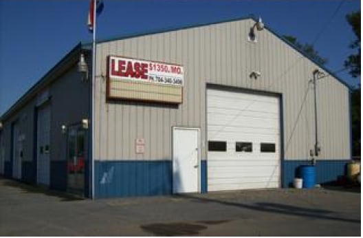
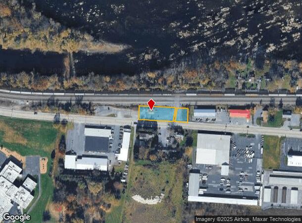
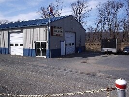
Property Record
1620 State Rd, Duncannon, PA 17020
NEARBY LISTINGS FOR SALE OR LEASE
Property Detail
1620 State Rd
Harrisburg-Carlisle, PA
Final Subdivision
210-134.01-010.001
OYLER ESTATE LOT 2, PB69-37
Vehiclerentalsvehiclesales
Perry
X
Pennsylvania
42099C0426E
2
2025
0.42 AC
2025
Harrisburg Area West
030301
Philadelphia
DEMOGRAPHICS near 1620 State Rd
1 Mile
3 Mile
5 Mile
2024 Total Population
438
4,533
24,055
2029 Population
449
4,599
25,060
Pop Growth 2024-2029
+ 2.51%
+ 1.46%
+ 4.18%
Average Age
46
46
42
2024 Total Households
163
1,817
9,901
HH Growth 2024-2029
+ 3.07%
+ 1.54%
+ 4.31%
Median Household Inc
$88,257
$89,845
$82,062
Avg Household Size
2.40
2.40
2.40
2024 Avg HH Vehicles
2.00
2.00
2.00
Median Home Value
$214,286
$231,555
$214,123
Median Year Built
1980
1975
1979
Nearby Places
Map Layers
Map Styles
 Street
 Aerial
- Restaurants
- Banks
- Shops
- Fitness
- Groceries
PUBLIC TRANSPORTATION
AIRPORT
Harrisburg International
DRIVE
WALK
Distance
Harrisburg International
36 min
22.6 mi
Freight Ports
Port of Baltimore
DRIVE
WALK
Distance
Port of Baltimore
131 min
91.4 mi
Nearby Properties
Address
Land Use
TOTAL SIZE
Lot Size
Zoning
Address
Land Use
TOTAL SIZE
Lot Size
Zoning
170.01 AC
RUR
Address
Land Use
TOTAL SIZE
Lot Size
Zoning
26.24 AC
RUR
Address
Land Use
TOTAL SIZE
Lot Size
Zoning
16 AC
RUR
Address
Land Use
TOTAL SIZE
Lot Size
Zoning
17.07 AC
MIX
Address
Land Use
TOTAL SIZE
Lot Size
Zoning
85.07 AC
Address
Land Use
TOTAL SIZE
Lot Size
Zoning
1,680.70 AC
RUR
Address
Land Use
TOTAL SIZE
Lot Size
Zoning
Address
Land Use
TOTAL SIZE
Lot Size
Zoning
14.18 AC
MIX
Address
Land Use
TOTAL SIZE
Lot Size
Zoning
119 AC
Address
Land Use
TOTAL SIZE
Lot Size
Zoning
113.59 AC
Address
Land Use
TOTAL SIZE
Lot Size
Zoning
110.54 AC
Address
Land Use
TOTAL SIZE
Lot Size
Zoning
12,064 SF
5.60 AC
Address
Land Use
TOTAL SIZE
Lot Size
Zoning
2.75 AC
MIX
Address
Land Use
TOTAL SIZE
Lot Size
Zoning
2.30 AC
MIX
Address
Land Use
TOTAL SIZE
Lot Size
Zoning
2.58 AC
MIX
Address
Land Use
TOTAL SIZE
Lot Size
Zoning
1.35 AC
MIX
Address
Land Use
TOTAL SIZE
Lot Size
Zoning
9.46 AC
MIX
Address
Land Use
TOTAL SIZE
Lot Size
Zoning
34 AC
Address
Land Use
TOTAL SIZE
Lot Size
Zoning
Address
Land Use
TOTAL SIZE
Lot Size
Zoning
340.57 AC
RUR
Address
Land Use
TOTAL SIZE
Lot Size
Zoning
7.55 AC
RUR
Address
Land Use
TOTAL SIZE
Lot Size
Zoning
35.64 AC
RUR
Address
Land Use
TOTAL SIZE
Lot Size
Zoning
Address
Land Use
TOTAL SIZE
Lot Size
Zoning
4.48 AC
MIX
Address
Land Use
TOTAL SIZE
Lot Size
Zoning
1.50 AC
RES
Address
Land Use
TOTAL SIZE
Lot Size
Zoning
1.20 AC
MIX
Address
Land Use
TOTAL SIZE
Lot Size
Zoning
2.33 AC
RUR
Address
Land Use
TOTAL SIZE
Lot Size
Zoning
0.46 AC
RES
Address
Land Use
TOTAL SIZE
Lot Size
Zoning
4.21 AC
RUR
Address
Land Use
TOTAL SIZE
Lot Size
Zoning
6.11 AC
MIX
The World's #1 Commercial Real Estate Marketplace
Connect with us
© 2025 CoStar Group
The information above has been obtained from sources believed reliable. While we do not doubt its accuracy we have not verified it and make no guarantee, warranty or representation about it. It is your responsibility to independently confirm its accuracy and completeness. Any projections, opinions, assumptions, or estimates used are for example only and do not represent the current or future performance of the property. The value of this transaction to you depends on tax and other factors which should be evaluated by your tax, financial, and legal advisors. You and your advisors should conduct a careful, independent investigation of the property to determine to your satisfaction the suitability of the property for your needs.