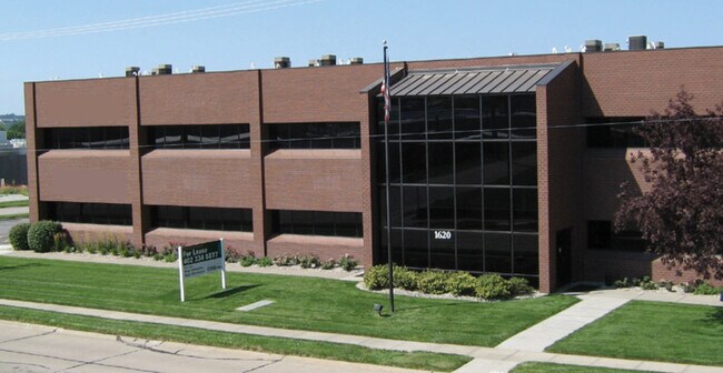
Property Record
1620 Wilshire Dr, Bellevue, NE 68005


NEARBY LISTINGS FOR SALE OR LEASE
-
-
View all Bellevue listings for lease on LoopNet.com
Property Detail
1620 Wilshire Dr
Omaha-Council Bluffs, NE-IA
Tillers 5Th Addition
011137061
LOT 1 TILLERS 5TH ADDITION
Commercialnec
Sarpy
X
Nebraska
31153C0093G
1
2024
2.02 AC
2025
Southeast Omaha
010401
Omaha/Council Bluffs
15,504 SF
DEMOGRAPHICS near 1620 Wilshire Dr
1 Mile
3 Mile
5 Mile
2024 Total Population
10,182
45,512
100,435
2029 Population
10,946
49,011
107,065
Pop Growth 2024-2029
+ 7.50%
+ 7.69%
+ 6.60%
Average Age
38
37
37
2024 Total Households
4,087
17,793
36,470
HH Growth 2024-2029
+ 7.66%
+ 7.86%
+ 6.90%
Median Household Inc
$48,949
$65,407
$71,291
Avg Household Size
2.30
2.50
2.70
2024 Avg HH Vehicles
2.00
2.00
2.00
Median Home Value
$165,074
$208,021
$216,803
Median Year Built
1970
1979
1981
Nearby Places
Map Layers
Map Styles
 Street
 Aerial
- Restaurants
- Banks
- Shops
- Fitness
- Groceries
PUBLIC TRANSPORTATION
AIRPORT
Eppley Airfield
DRIVE
WALK
Distance
Eppley Airfield
35 min
22.3 mi
Freight Ports
Tulsa Port Of Catoosa
DRIVE
WALK
Distance
Tulsa Port Of Catoosa
477 min
426.6 mi
SALE & LEASE HISTORY
LISTING DATE
SALE/LEASE

Sep 25, 2016
For Lease
Sep 22, 2020
For Lease
Sep 22, 2020
For Sale
Nov 05, 2021
For Lease
Mar 13, 2019
For Sale
Nearby Properties
Address
Land Use
TOTAL SIZE
Lot Size
Zoning
Address
Land Use
TOTAL SIZE
Lot Size
Zoning
72.91 AC
Address
Land Use
TOTAL SIZE
Lot Size
Zoning
349,722 SF
25.22 AC
R6
Address
Land Use
TOTAL SIZE
Lot Size
Zoning
315,685 SF
21.57 AC
RG10
Address
Land Use
TOTAL SIZE
Lot Size
Zoning
394,017 SF
11.62 AC
Address
Land Use
TOTAL SIZE
Lot Size
Zoning
277,073 SF
16.78 AC
Address
Land Use
TOTAL SIZE
Lot Size
Zoning
294,334 SF
19.14 AC
R6
Address
Land Use
TOTAL SIZE
Lot Size
Zoning
165,950 SF
11.57 AC
MH
Address
Land Use
TOTAL SIZE
Lot Size
Zoning
2,295 SF
11.77 AC
Address
Land Use
TOTAL SIZE
Lot Size
Zoning
257,106 SF
21.44 AC
R6
Address
Land Use
TOTAL SIZE
Lot Size
Zoning
12.60 AC
Address
Land Use
TOTAL SIZE
Lot Size
Zoning
222,090 SF
7.74 AC
R6
Address
Land Use
TOTAL SIZE
Lot Size
Zoning
238,428 SF
18.64 AC
R5
Address
Land Use
TOTAL SIZE
Lot Size
Zoning
162,717 SF
6.73 AC
R6
Address
Land Use
TOTAL SIZE
Lot Size
Zoning
170,760 SF
10.30 AC
RG10
Address
Land Use
TOTAL SIZE
Lot Size
Zoning
280,482 SF
11.64 AC
R6
Address
Land Use
TOTAL SIZE
Lot Size
Zoning
193,490 SF
9.35 AC
Address
Land Use
TOTAL SIZE
Lot Size
Zoning
89,181 SF
4.85 AC
Address
Land Use
TOTAL SIZE
Lot Size
Zoning
28,444 SF
0.85 AC
Address
Land Use
TOTAL SIZE
Lot Size
Zoning
387,400 SF
6.13 AC
Address
Land Use
TOTAL SIZE
Lot Size
Zoning
133,134 SF
6.03 AC
Address
Land Use
TOTAL SIZE
Lot Size
Zoning
52,791 SF
8.09 AC
Address
Land Use
TOTAL SIZE
Lot Size
Zoning
209,767 SF
21.17 AC
MU
Address
Land Use
TOTAL SIZE
Lot Size
Zoning
137,181 SF
16.36 AC
MU
Address
Land Use
TOTAL SIZE
Lot Size
Zoning
134,709 SF
2.32 AC
MU
Address
Land Use
TOTAL SIZE
Lot Size
Zoning
138,942 SF
2.86 AC
Address
Land Use
TOTAL SIZE
Lot Size
Zoning
59,022 SF
4.86 AC
Address
Land Use
TOTAL SIZE
Lot Size
Zoning
1,950 SF
3.59 AC
Address
Land Use
TOTAL SIZE
Lot Size
Zoning
36,145 SF
2 AC
Address
Land Use
TOTAL SIZE
Lot Size
Zoning
3,900 SF
3.12 AC
RG15
Address
Land Use
TOTAL SIZE
Lot Size
Zoning
128,125 SF
8.37 AC
GI
The World's #1 Commercial Real Estate Marketplace
Connect with us
© 2026 CoStar Group
The information above has been obtained from sources believed reliable. While we do not doubt its accuracy we have not verified it and make no guarantee, warranty or representation about it. It is your responsibility to independently confirm its accuracy and completeness. Any projections, opinions, assumptions, or estimates used are for example only and do not represent the current or future performance of the property. The value of this transaction to you depends on tax and other factors which should be evaluated by your tax, financial, and legal advisors. You and your advisors should conduct a careful, independent investigation of the property to determine to your satisfaction the suitability of the property for your needs.