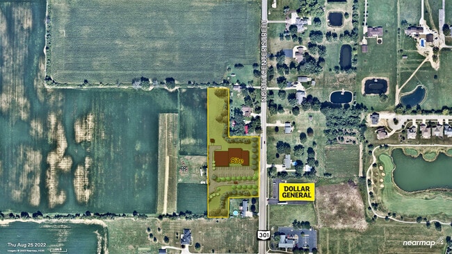
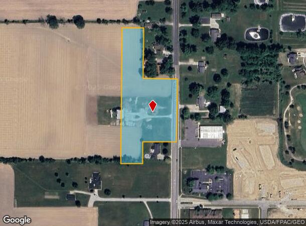
Property Record
16206 State Route 301, Lagrange, OH 44050
This Property Is For Sale
NEARBY LISTINGS FOR SALE OR LEASE
Property Detail
16206 State Route 301
Cleveland-Elyria, OH
Lagrange
15-00-036-000-024
20090315251
Agriculturalland
Lorain
X
Ohio
39093C0326D
36
2024
4.18 AC
2024
Lorain County
094102
Cleveland
1,494 SF
DEMOGRAPHICS near 16206 State Route 301
1 mile
3 mile
5 mile
2024 Total Population
2,843
5,405
16,839
2029 Population
2,973
5,579
17,323
Pop Growth 2024-2029
+ 4.57%
+ 3.22%
+ 2.87%
Average Age
41
42
44
2024 Total Households
1,066
2,055
5,877
HH Growth 2024-2029
+ 4.60%
+ 3.21%
+ 3.10%
Median Household Inc
$84,392
$87,160
$79,909
Avg Household Size
2.70
2.60
2.60
2024 Avg HH Vehicles
2.00
2.00
2.00
Median Home Value
$232,331
$235,227
$230,475
Median Year Built
1991
1984
1978
Nearby Places
Map Layers
Map Styles
 Street
 Aerial
Transit
 Traffic
 Biking
Places
Listings with unknown addresses are not visible on the map
- Restaurants
- Banks
- Shops
- Fitness
- Groceries
PUBLIC TRANSPORTATION
COMMUTER RAIL
Elyria Amtrak (Capitol Limited - Amtrak, Lake Shore Limited - Amtrak)
Drive
Walk
Distance
Elyria Amtrak (Capitol Limited - Amtrak, Lake Shore Limited - Amtrak)
16 min
9.0 mi
AIRPORT
Cleveland-Hopkins International
Drive
Walk
Distance
Cleveland-Hopkins International
32 min
22.2 mi
Freight Ports
Port of Toledo
Drive
Walk
Distance
Port of Toledo
122 min
98.0 mi
Nearby Properties
Address
Land Use
TOTAL SIZE
Lot Size
Zoning
Address
Land Use
TOTAL SIZE
Lot Size
Zoning
242,218 SF
58.63 AC
Address
Land Use
TOTAL SIZE
Lot Size
Zoning
62,653 SF
10 AC
Address
Land Use
TOTAL SIZE
Lot Size
Zoning
104,257 SF
4.11 AC
Address
Land Use
TOTAL SIZE
Lot Size
Zoning
15,200 SF
9.50 AC
Address
Land Use
TOTAL SIZE
Lot Size
Zoning
10,480 SF
0.50 AC
Address
Land Use
TOTAL SIZE
Lot Size
Zoning
2,112 SF
72.85 AC
Address
Land Use
TOTAL SIZE
Lot Size
Zoning
7,416 SF
6.36 AC
Address
Land Use
TOTAL SIZE
Lot Size
Zoning
62,040 SF
9.62 AC
Address
Land Use
TOTAL SIZE
Lot Size
Zoning
104,257 SF
16.86 AC
Address
Land Use
TOTAL SIZE
Lot Size
Zoning
7.18 AC
Address
Land Use
TOTAL SIZE
Lot Size
Zoning
51,998 SF
9.01 AC
Address
Land Use
TOTAL SIZE
Lot Size
Zoning
28,598 SF
6 AC
Address
Land Use
TOTAL SIZE
Lot Size
Zoning
3,672 SF
1.71 AC
Address
Land Use
TOTAL SIZE
Lot Size
Zoning
4,257 SF
0.29 AC
Address
Land Use
TOTAL SIZE
Lot Size
Zoning
44,900 SF
6.05 AC
Address
Land Use
TOTAL SIZE
Lot Size
Zoning
9,180 SF
7.66 AC
Address
Land Use
TOTAL SIZE
Lot Size
Zoning
47,576 SF
1.02 AC
Address
Land Use
TOTAL SIZE
Lot Size
Zoning
26,640 SF
3.69 AC
Address
Land Use
TOTAL SIZE
Lot Size
Zoning
43,817 SF
13.63 AC
Address
Land Use
TOTAL SIZE
Lot Size
Zoning
121.16 AC
Address
Land Use
TOTAL SIZE
Lot Size
Zoning
5,486 SF
1.92 AC
Address
Land Use
TOTAL SIZE
Lot Size
Zoning
980 SF
12.79 AC
Address
Land Use
TOTAL SIZE
Lot Size
Zoning
3,912 SF
120.90 AC
Address
Land Use
TOTAL SIZE
Lot Size
Zoning
20,288 SF
5.49 AC
Address
Land Use
TOTAL SIZE
Lot Size
Zoning
84.89 AC
Address
Land Use
TOTAL SIZE
Lot Size
Zoning
13,368 SF
23.64 AC
Address
Land Use
TOTAL SIZE
Lot Size
Zoning
3,072 SF
2.49 AC
Address
Land Use
TOTAL SIZE
Lot Size
Zoning
50 AC
Address
Land Use
TOTAL SIZE
Lot Size
Zoning
3,561 SF
111.10 AC
Address
Land Use
TOTAL SIZE
Lot Size
Zoning
2,996 SF
0.78 AC
The World's #1 Commercial Real Estate Marketplace
Connect with us
© 2026 CoStar Group
The information above has been obtained from sources believed reliable. While we do not doubt its accuracy we have not verified it and make no guarantee, warranty or representation about it. It is your responsibility to independently confirm its accuracy and completeness. Any projections, opinions, assumptions, or estimates used are for example only and do not represent the current or future performance of the property. The value of this transaction to you depends on tax and other factors which should be evaluated by your tax, financial, and legal advisors. You and your advisors should conduct a careful, independent investigation of the property to determine to your satisfaction the suitability of the property for your needs.