Property Record
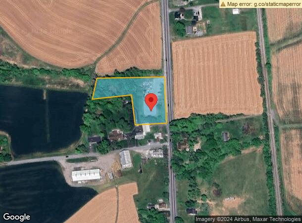
16208 Hanover Pike, Hampstead, MD 21074
NEARBY LISTINGS FOR SALE OR LEASE
Property Detail
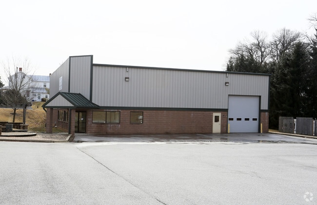
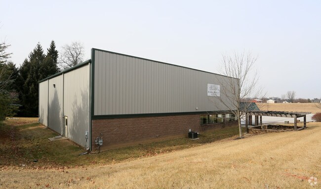
16208 Hanover Pike
04-1600004090
2.026 AC
Warehouse
Baltimore
X
Maryland
2400100080G
2.03 AC
2024
Reisterstown Rd
2025
Baltimore
405000
Baltimore-Columbia-Towson, MD
6,495 SF
DEMOGRAPHICS near 16208 Hanover Pike
1 mile
3 mile
5 mile
2024 Total Population
678
10,032
21,679
2029 Population
675
10,220
22,066
Pop Growth 2024-2029
(0.44%)
+ 1.87%
+ 1.79%
Average Age
42
41
42
2024 Total Households
243
3,890
8,217
HH Growth 2024-2029
(0.41%)
+ 1.95%
+ 1.84%
Median Household Inc
$100,735
$92,571
$98,274
Avg Household Size
2.70
2.50
2.60
2024 Avg HH Vehicles
3.00
2.00
2.00
Median Home Value
$514,881
$344,597
$370,113
Median Year Built
1978
1983
1981
Nearby Places
Map Layers
Map Styles
 Street
 Aerial
Transit
 Traffic
 Biking
Places
Listings with unknown addresses are not visible on the map
- Restaurants
- Banks
- Shops
- Fitness
- Groceries
PUBLIC TRANSPORTATION
AIRPORT
Baltimore/Washington International Thurgood Marshall
Drive
Walk
Distance
Baltimore/Washington International Thurgood Marshall
47 min
31.3 mi
Freight Ports
Port of Baltimore
Drive
Walk
Distance
Port of Baltimore
47 min
31.6 mi
SALE & LEASE HISTORY
LISTING DATE
SALE/LEASE

Nov 28, 2017
For Lease
Nov 28, 2017
For Sale
Nearby Properties
Address
Land Use
TOTAL SIZE
Lot Size
Zoning
Address
Land Use
TOTAL SIZE
Lot Size
Zoning
1,034,020 SF
51.58 AC
I-1
Address
Land Use
TOTAL SIZE
Lot Size
Zoning
842,295 SF
134.68 AC
RESTR
Address
Land Use
TOTAL SIZE
Lot Size
Zoning
115,358 SF
26.99 AC
PUBLI
Address
Land Use
TOTAL SIZE
Lot Size
Zoning
24,592 SF
1.17 AC
GLC3*
Address
Land Use
TOTAL SIZE
Lot Size
Zoning
58,095 SF
19.95 AC
Address
Land Use
TOTAL SIZE
Lot Size
Zoning
52,728 SF
13.88 AC
GENER
Address
Land Use
TOTAL SIZE
Lot Size
Zoning
210,288 SF
38.44 AC
RESTR
Address
Land Use
TOTAL SIZE
Lot Size
Zoning
39,992 SF
19.57 AC
PUBLI
Address
Land Use
TOTAL SIZE
Lot Size
Zoning
13,120 SF
3.15 AC
Address
Land Use
TOTAL SIZE
Lot Size
Zoning
34,584 SF
6.02 AC
RESTR
Address
Land Use
TOTAL SIZE
Lot Size
Zoning
10,642 SF
2.30 AC
LOCAL
Address
Land Use
TOTAL SIZE
Lot Size
Zoning
7,696 SF
2.84 AC
GENER
Address
Land Use
TOTAL SIZE
Lot Size
Zoning
20,705 SF
182.66 AC
RC2
Address
Land Use
TOTAL SIZE
Lot Size
Zoning
260,550 SF
49.38 AC
HISTO
Address
Land Use
TOTAL SIZE
Lot Size
Zoning
11,860 SF
1.64 AC
LOCAL
Address
Land Use
TOTAL SIZE
Lot Size
Zoning
3,820 SF
103 AC
R-750
Address
Land Use
TOTAL SIZE
Lot Size
Zoning
13,657 SF
4.05 AC
PRIVA
Address
Land Use
TOTAL SIZE
Lot Size
Zoning
33,350 SF
3.50 AC
HISTO
Address
Land Use
TOTAL SIZE
Lot Size
Zoning
3,864 SF
4.87 AC
C-2
Address
Land Use
TOTAL SIZE
Lot Size
Zoning
11,423 SF
35.51 AC
Address
Land Use
TOTAL SIZE
Lot Size
Zoning
9,100 SF
0.85 AC
GENER
Address
Land Use
TOTAL SIZE
Lot Size
Zoning
2,120 SF
1.10 AC
RES O
Address
Land Use
TOTAL SIZE
Lot Size
Zoning
1,892 SF
36.10 AC
RESTR
Address
Land Use
TOTAL SIZE
Lot Size
Zoning
71.35 AC
R-100
Address
Land Use
TOTAL SIZE
Lot Size
Zoning
7,372 SF
2.55 AC
R-100
Address
Land Use
TOTAL SIZE
Lot Size
Zoning
3,496 SF
2.95 AC
BL
Address
Land Use
TOTAL SIZE
Lot Size
Zoning
9,600 SF
16.71 AC
AGRIC
Address
Land Use
TOTAL SIZE
Lot Size
Zoning
3,008 SF
0.69 AC
HISTO
Address
Land Use
TOTAL SIZE
Lot Size
Zoning
6,948 SF
6.25 AC
AGRIC
Address
Land Use
TOTAL SIZE
Lot Size
Zoning
9,540 SF
57.09 AC
The World's #1 Commercial Real Estate Marketplace
Connect with us
© 2026 CoStar Group
The information above has been obtained from sources believed reliable. While we do not doubt its accuracy we have not verified it and make no guarantee, warranty or representation about it. It is your responsibility to independently confirm its accuracy and completeness. Any projections, opinions, assumptions, or estimates used are for example only and do not represent the current or future performance of the property. The value of this transaction to you depends on tax and other factors which should be evaluated by your tax, financial, and legal advisors. You and your advisors should conduct a careful, independent investigation of the property to determine to your satisfaction the suitability of the property for your needs.