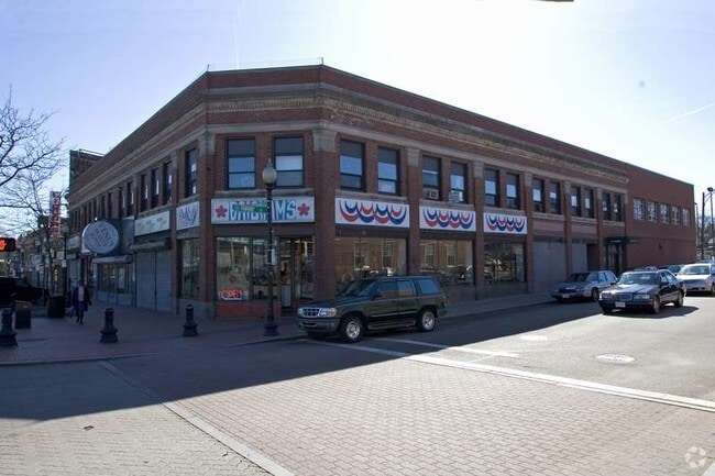
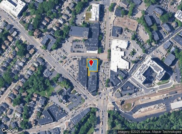
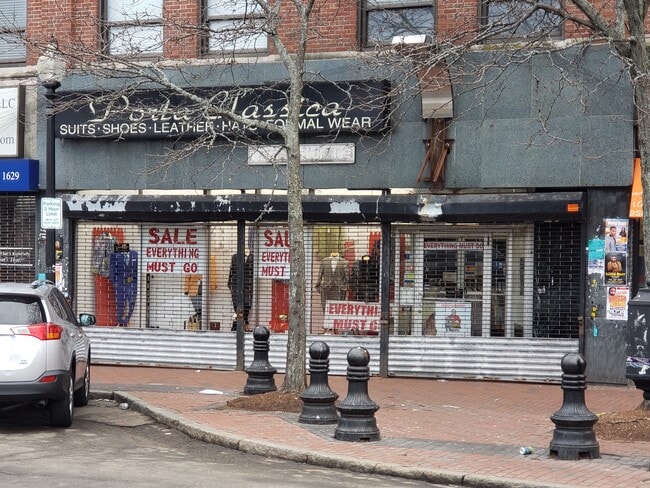
Property Record
10 Fairway St, Mattapan, MA 02126

Current Lease Availabilities
NEARBY LISTINGS FOR SALE OR LEASE
Property Detail
10 Fairway St
Regionalshoppingcenterormallwithanchorstore
Suffolk
X
Massachusetts
25021C0063F
0.27 AC
2025
South Suffolk County
2025
Boston
101001
Boston-Cambridge-Newton, MA-NH
17,135 SF
MATT-000000-000018-001138-000001
DEMOGRAPHICS near 10 Fairway St
1 Mile
3 Mile
5 Mile
2024 Total Population
31,658
206,207
489,925
2029 Population
30,509
195,447
469,625
Pop Growth 2024-2029
(3.63%)
(5.22%)
(4.14%)
Average Age
41
40
39
2024 Total Households
11,310
75,296
187,348
HH Growth 2024-2029
(4.18%)
(5.86%)
(4.51%)
Median Household Inc
$74,526
$81,835
$82,385
Avg Household Size
2.70
2.60
2.40
2024 Avg HH Vehicles
1.00
1.00
1.00
Median Home Value
$518,837
$642,958
$680,575
Median Year Built
1949
1948
1949
Nearby Places
Map Layers
Map Styles
 Street
 Aerial
- Restaurants
- Banks
- Shops
- Fitness
- Groceries
PUBLIC TRANSPORTATION
TRANSIT/SUBWAY
Mattapan Station (Ashmont Mattapan High Speed Line - Massachusetts Bay Transportation Authority Subway (The T))
DRIVE
WALK
Distance
Mattapan Station (Ashmont Mattapan High Speed Line - Massachusetts Bay Transportation Authority Subway (The T))
1 min
4 min
0.2 mi
Capen Street Station (Ashmont Mattapan High Speed Line - Massachusetts Bay Transportation Authority Subway (The T))
DRIVE
WALK
Distance
Capen Street Station (Ashmont Mattapan High Speed Line - Massachusetts Bay Transportation Authority Subway (The T))
3 min
15 min
0.8 mi
Valley Road Station (Ashmont Mattapan High Speed Line - Massachusetts Bay Transportation Authority Subway (The T))
DRIVE
WALK
Distance
Valley Road Station (Ashmont Mattapan High Speed Line - Massachusetts Bay Transportation Authority Subway (The T))
3 min
19 min
1.0 mi
COMMUTER RAIL
Blue Hill Avenue (Fairmount Line - MBTA, Franklin/Foxboro Line - MBTA)
DRIVE
WALK
Distance
Blue Hill Avenue (Fairmount Line - MBTA, Franklin/Foxboro Line - MBTA)
1 min
8 min
0.4 mi
Morton Street (Fairmount Line - Massachusetts Bay Transportation Authority Commuter Rail (Purple Line))
DRIVE
WALK
Distance
Morton Street (Fairmount Line - Massachusetts Bay Transportation Authority Commuter Rail (Purple Line))
3 min
1.3 mi
AIRPORT
General Edward Lawrence Logan International
DRIVE
WALK
Distance
General Edward Lawrence Logan International
19 min
10.0 mi
Freight Ports
Port of Boston
DRIVE
WALK
Distance
Port of Boston
16 min
7.7 mi
Nearby Properties
Address
Land Use
TOTAL SIZE
Lot Size
Zoning
Address
Land Use
TOTAL SIZE
Lot Size
Zoning
152,495 SF
6.51 AC
Address
Land Use
TOTAL SIZE
Lot Size
Zoning
45,000 SF
14.30 AC
E
Address
Land Use
TOTAL SIZE
Lot Size
Zoning
179.13 AC
E
Address
Land Use
TOTAL SIZE
Lot Size
Zoning
225,042 SF
63.16 AC
RA
Address
Land Use
TOTAL SIZE
Lot Size
Zoning
1,660.52 AC
RA
Address
Land Use
TOTAL SIZE
Lot Size
Zoning
1,940 SF
58.17 AC
E
Address
Land Use
TOTAL SIZE
Lot Size
Zoning
240.18 AC
E
Address
Land Use
TOTAL SIZE
Lot Size
Zoning
728,348 SF
11.71 AC
C
Address
Land Use
TOTAL SIZE
Lot Size
Zoning
228,215 SF
2.44 AC
RC
Address
Land Use
TOTAL SIZE
Lot Size
Zoning
526,040 SF
27.79 AC
E
Address
Land Use
TOTAL SIZE
Lot Size
Zoning
270,991 SF
33.25 AC
RA
Address
Land Use
TOTAL SIZE
Lot Size
Zoning
21,830 SF
158.48 AC
E
Address
Land Use
TOTAL SIZE
Lot Size
Zoning
377,249 SF
2.81 AC
RC
Address
Land Use
TOTAL SIZE
Lot Size
Zoning
173,630 SF
4.46 AC
E
Address
Land Use
TOTAL SIZE
Lot Size
Zoning
17.85 AC
BUSC
Address
Land Use
TOTAL SIZE
Lot Size
Zoning
26,569 SF
45.93 AC
RC
Address
Land Use
TOTAL SIZE
Lot Size
Zoning
217,302 SF
13.47 AC
RA
Address
Land Use
TOTAL SIZE
Lot Size
Zoning
221,500 SF
4.99 AC
E
Address
Land Use
TOTAL SIZE
Lot Size
Zoning
247,316 SF
2.75 AC
E
Address
Land Use
TOTAL SIZE
Lot Size
Zoning
83,891 SF
3.47 AC
RA
Address
Land Use
TOTAL SIZE
Lot Size
Zoning
475,102 SF
36.81 AC
A
Address
Land Use
TOTAL SIZE
Lot Size
Zoning
108,500 SF
2.38 AC
E
Address
Land Use
TOTAL SIZE
Lot Size
Zoning
2.35 AC
E
Address
Land Use
TOTAL SIZE
Lot Size
Zoning
156,310 SF
9.40 AC
E
Address
Land Use
TOTAL SIZE
Lot Size
Zoning
20,580 SF
20.51 AC
E
Address
Land Use
TOTAL SIZE
Lot Size
Zoning
153,360 SF
4.94 AC
E
Address
Land Use
TOTAL SIZE
Lot Size
Zoning
130,867 SF
15.29 AC
RA
Address
Land Use
TOTAL SIZE
Lot Size
Zoning
138,986 SF
10.07 AC
E
Address
Land Use
TOTAL SIZE
Lot Size
Zoning
296,340 SF
4.58 AC
A
Address
Land Use
TOTAL SIZE
Lot Size
Zoning
99,497 SF
4.12 AC
E
The World's #1 Commercial Real Estate Marketplace
Connect with us
© 2025 CoStar Group
The information above has been obtained from sources believed reliable. While we do not doubt its accuracy we have not verified it and make no guarantee, warranty or representation about it. It is your responsibility to independently confirm its accuracy and completeness. Any projections, opinions, assumptions, or estimates used are for example only and do not represent the current or future performance of the property. The value of this transaction to you depends on tax and other factors which should be evaluated by your tax, financial, and legal advisors. You and your advisors should conduct a careful, independent investigation of the property to determine to your satisfaction the suitability of the property for your needs.