Property Record
1621 163Rd Ave, San Leandro, CA 94578


NEARBY LISTINGS FOR SALE OR LEASE
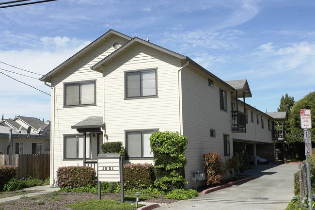
Property Detail
1621 163Rd Ave
Oakland-Fremont-Berkeley, CA
Gansberger
080-0063-016-01
LOT: 00001 BLK: 0016 AR: 0080 PAGE: 0063
Quadruplex
Alameda
X
California
06001C0278G
2
2024
0.23 AC
2025
Ashland
433900
East Bay/Oakland
3,392 SF
DEMOGRAPHICS near 1621 163Rd Ave
1 Mile
3 Mile
5 Mile
2024 Total Population
29,490
203,380
372,048
2029 Population
28,418
196,378
359,236
Pop Growth 2024-2029
(3.64%)
(3.44%)
(3.44%)
Average Age
39
41
40
2024 Total Households
9,682
68,722
120,441
HH Growth 2024-2029
(3.85%)
(3.63%)
(3.64%)
Median Household Inc
$77,975
$91,130
$93,031
Avg Household Size
2.90
2.90
3.00
2024 Avg HH Vehicles
2.00
2.00
2.00
Median Home Value
$712,367
$754,117
$759,721
Median Year Built
1964
1960
1962
Nearby Places
Map Layers
Map Styles
 Street
 Aerial
- Restaurants
- Banks
- Shops
- Fitness
- Groceries
PUBLIC TRANSPORTATION
COMMUTER RAIL
DRIVE
WALK
Distance
9 min
3.4 mi
DRIVE
WALK
Distance
9 min
3.5 mi
AIRPORT
Metro Oakland International
DRIVE
WALK
Distance
Metro Oakland International
15 min
9.2 mi
San Francisco International
DRIVE
WALK
Distance
San Francisco International
36 min
27.0 mi
Norman Y Mineta San Jose International
DRIVE
WALK
Distance
Norman Y Mineta San Jose International
41 min
31.5 mi
Freight Ports
Port of Oakland
DRIVE
WALK
Distance
Port of Oakland
19 min
13.7 mi
Nearby Properties
Address
Land Use
TOTAL SIZE
Lot Size
Zoning
Address
Land Use
TOTAL SIZE
Lot Size
Zoning
298,256 SF
12.16 AC
Address
Land Use
TOTAL SIZE
Lot Size
Zoning
4.90 AC
Address
Land Use
TOTAL SIZE
Lot Size
Zoning
437,104 SF
0.73 AC
Address
Land Use
TOTAL SIZE
Lot Size
Zoning
2.48 AC
Address
Land Use
TOTAL SIZE
Lot Size
Zoning
726,931 SF
37.03 AC
Address
Land Use
TOTAL SIZE
Lot Size
Zoning
1.50 AC
Address
Land Use
TOTAL SIZE
Lot Size
Zoning
187,926 SF
1.19 AC
Address
Land Use
TOTAL SIZE
Lot Size
Zoning
693,679 SF
43.49 AC
Address
Land Use
TOTAL SIZE
Lot Size
Zoning
294,146 SF
14.22 AC
Address
Land Use
TOTAL SIZE
Lot Size
Zoning
133,974 SF
4.99 AC
Address
Land Use
TOTAL SIZE
Lot Size
Zoning
240,668 SF
14.11 AC
Address
Land Use
TOTAL SIZE
Lot Size
Zoning
241,382 SF
12.72 AC
Address
Land Use
TOTAL SIZE
Lot Size
Zoning
297,592 SF
11.65 AC
Address
Land Use
TOTAL SIZE
Lot Size
Zoning
310,072 SF
14.96 AC
Address
Land Use
TOTAL SIZE
Lot Size
Zoning
458,489 SF
27.38 AC
Address
Land Use
TOTAL SIZE
Lot Size
Zoning
228,736 SF
5.95 AC
Address
Land Use
TOTAL SIZE
Lot Size
Zoning
169,371 SF
4.63 AC
Address
Land Use
TOTAL SIZE
Lot Size
Zoning
625,101 SF
35.95 AC
Address
Land Use
TOTAL SIZE
Lot Size
Zoning
168,104 SF
13.73 AC
Address
Land Use
TOTAL SIZE
Lot Size
Zoning
105,730 SF
5.32 AC
Address
Land Use
TOTAL SIZE
Lot Size
Zoning
243,524 SF
15.17 AC
Address
Land Use
TOTAL SIZE
Lot Size
Zoning
149,602 SF
6.90 AC
Address
Land Use
TOTAL SIZE
Lot Size
Zoning
140,850 SF
9.98 AC
Address
Land Use
TOTAL SIZE
Lot Size
Zoning
427,400 SF
17.34 AC
Address
Land Use
TOTAL SIZE
Lot Size
Zoning
89,968 SF
5 AC
Address
Land Use
TOTAL SIZE
Lot Size
Zoning
119,800 SF
5.72 AC
Address
Land Use
TOTAL SIZE
Lot Size
Zoning
178,560 SF
8.76 AC
Address
Land Use
TOTAL SIZE
Lot Size
Zoning
93,258 SF
6.24 AC
Address
Land Use
TOTAL SIZE
Lot Size
Zoning
120,441 SF
1.34 AC
Address
Land Use
TOTAL SIZE
Lot Size
Zoning
152,950 SF
4.96 AC
The World's #1 Commercial Real Estate Marketplace
Connect with us
© 2026 CoStar Group
The information above has been obtained from sources believed reliable. While we do not doubt its accuracy we have not verified it and make no guarantee, warranty or representation about it. It is your responsibility to independently confirm its accuracy and completeness. Any projections, opinions, assumptions, or estimates used are for example only and do not represent the current or future performance of the property. The value of this transaction to you depends on tax and other factors which should be evaluated by your tax, financial, and legal advisors. You and your advisors should conduct a careful, independent investigation of the property to determine to your satisfaction the suitability of the property for your needs.