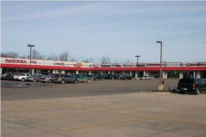
Property Record
1621 E M 21, Owosso, MI 48867

Property Detail
1621 E M 21
007-17-300-007-005
SEC 17, T7N, R3E COMM AT THE S 14 CORN OF SEC 17, TH W 443.80 FT ALONG THE S LINE OF SEC 17, TH N 52.87 FT TO NLY ROW LINE OF
Wholesaleoutletdiscountstore
SHIAWASSEE
B and X Area of moderate flood hazard, usually the area between the limits of the 100-year and 500-year floods.
Michigan
2024
24.89 AC
2025
Michigan North Central Area
030700
Other Market Areas
207,259 SF
Owosso, MI
NEARBY LISTINGS FOR SALE OR LEASE
DEMOGRAPHICS near 1621 E M 21
1 mile
3 mile
5 mile
2025 Total Population
1,886
22,729
27,435
2030 Population
1,891
22,750
27,459
Pop Growth 2025-2030
+ 0.27%
+ 0.09%
+ 0.09%
Average Age
43
41
42
2025 Total Households
819
9,679
11,686
HH Growth 2025-2030
+ 0.12%
+ 0.06%
+ 0.07%
Median Household Inc
$48,210
$49,803
$49,311
Avg Household Size
2.20
2.30
2.30
2025 Avg HH Vehicles
2.00
2.00
2.00
Median Home Value
$171,794
$146,880
$149,623
Median Year Built
1979
1958
1960
Nearby Places
Map Layers
Map Styles
 Street
 Aerial
Layers
 Traffic
 Biking
Places
Listings with unknown addresses are not visible on the map
- Restaurants
- Banks
- Shops
- Fitness
- Groceries
PUBLIC TRANSPORTATION
AIRPORT
Bishop International
Drive
Walk
Distance
Bishop International
43 min
25.2 mi
Capital Region International
Drive
Walk
Distance
Capital Region International
56 min
39.4 mi
Freight Ports
Port of Toledo
Drive
Walk
Distance
Port of Toledo
161 min
134.0 mi
Nearby Properties
Address
Land Use
TOTAL SIZE
Lot Size
Zoning
Address
Land Use
TOTAL SIZE
Lot Size
Zoning
171,070 SF
38 AC
Address
Land Use
TOTAL SIZE
Lot Size
Zoning
20.30 AC
Address
Land Use
TOTAL SIZE
Lot Size
Zoning
4,960 SF
6.83 AC
RA
Address
Land Use
TOTAL SIZE
Lot Size
Zoning
10,100 SF
17.75 AC
Address
Land Use
TOTAL SIZE
Lot Size
Zoning
7.10 AC
Address
Land Use
TOTAL SIZE
Lot Size
Zoning
10.25 AC
Address
Land Use
TOTAL SIZE
Lot Size
Zoning
93,128 SF
10.98 AC
Address
Land Use
TOTAL SIZE
Lot Size
Zoning
16,202 SF
5.15 AC
Address
Land Use
TOTAL SIZE
Lot Size
Zoning
50,301 SF
8.20 AC
Address
Land Use
TOTAL SIZE
Lot Size
Zoning
1.72 AC
Address
Land Use
TOTAL SIZE
Lot Size
Zoning
17.17 AC
Address
Land Use
TOTAL SIZE
Lot Size
Zoning
8.50 AC
RA
Address
Land Use
TOTAL SIZE
Lot Size
Zoning
56,456 SF
6.50 AC
Address
Land Use
TOTAL SIZE
Lot Size
Zoning
0.64 AC
Address
Land Use
TOTAL SIZE
Lot Size
Zoning
11.05 AC
Address
Land Use
TOTAL SIZE
Lot Size
Zoning
23,760 SF
383 AC
Address
Land Use
TOTAL SIZE
Lot Size
Zoning
15.80 AC
Address
Land Use
TOTAL SIZE
Lot Size
Zoning
18.83 AC
Address
Land Use
TOTAL SIZE
Lot Size
Zoning
23.09 AC
Address
Land Use
TOTAL SIZE
Lot Size
Zoning
11,014 SF
2.61 AC
Address
Land Use
TOTAL SIZE
Lot Size
Zoning
4.16 AC
Address
Land Use
TOTAL SIZE
Lot Size
Zoning
2.52 AC
Address
Land Use
TOTAL SIZE
Lot Size
Zoning
0.39 AC
Address
Land Use
TOTAL SIZE
Lot Size
Zoning
212,405 SF
29 AC
Address
Land Use
TOTAL SIZE
Lot Size
Zoning
10.56 AC
Address
Land Use
TOTAL SIZE
Lot Size
Zoning
37.80 AC
Address
Land Use
TOTAL SIZE
Lot Size
Zoning
24,116 SF
3.70 AC
Address
Land Use
TOTAL SIZE
Lot Size
Zoning
8.20 AC
Address
Land Use
TOTAL SIZE
Lot Size
Zoning
6,390 SF
9 AC
The World's #1 Commercial Real Estate Marketplace
Connect with us
© 2026 CoStar Group
The information above has been obtained from sources believed reliable. While we do not doubt its accuracy we have not verified it and make no guarantee, warranty or representation about it. It is your responsibility to independently confirm its accuracy and completeness. Any projections, opinions, assumptions, or estimates used are for example only and do not represent the current or future performance of the property. The value of this transaction to you depends on tax and other factors which should be evaluated by your tax, financial, and legal advisors. You and your advisors should conduct a careful, independent investigation of the property to determine to your satisfaction the suitability of the property for your needs.