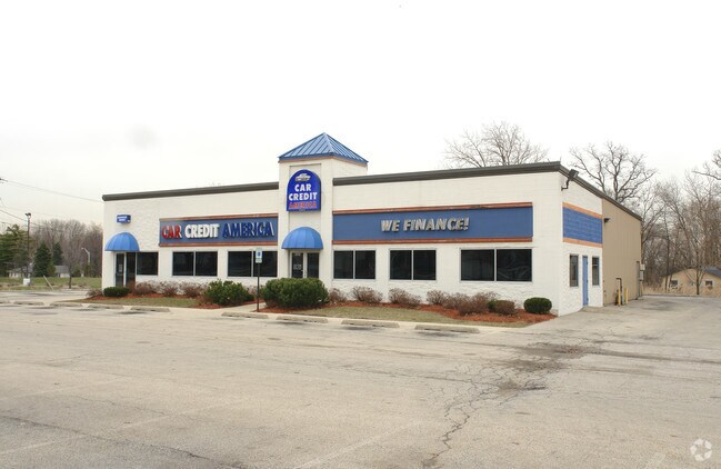
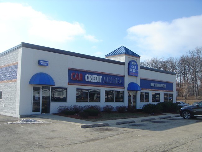
Property Record
1621 E New York St, Aurora, IL 60505
Save to a Folder
{{folder.Name}}
{{folder.ListingIds.length}} Properties
{{folder.ListingIds.length}} Property
Create a New Folder
Property Detail
1621 E New York St
Chicago-Naperville-Elgin, IL-IN
OGDEN GARDENS - LOTS 394 THRU 399 (EX PT TAKEN FOR RD AS DESC IN DOC 2020K020934)
15-24-377-021
Kane
Commercialnec
Illinois
B and X Area of moderate flood hazard, usually the area between the limits of the 100-year and 500-year floods.
394-3
2025
Western East/West Corr
2025
Chicago
854402
NEARBY LISTINGS FOR SALE OR LEASE
DEMOGRAPHICS near 1621 E New York St
1 mile
3 mile
5 mile
2025 Total Population
12,911
125,456
266,564
2030 Population
12,924
126,554
271,100
Pop Growth 2025-2030
+ 0.10%
+ 0.88%
+ 1.70%
Average Age
36
37
37
2025 Total Households
3,741
41,113
91,478
HH Growth 2025-2030
+ 0.21%
+ 1.02%
+ 1.76%
Median Household Inc
$95,807
$87,948
$97,029
Avg Household Size
3.30
2.90
2.80
2025 Avg HH Vehicles
2.00
2.00
2.00
Median Home Value
$244,268
$263,927
$290,325
Median Year Built
1972
1983
1989
Nearby Places
Map Layers
Map Styles
 Street
 Aerial
Layers
 Traffic
 Biking
Places
Listings with unknown addresses are not visible on the map
- Restaurants
- Banks
- Shops
- Fitness
- Groceries
PUBLIC TRANSPORTATION
COMMUTER RAIL
Aurora Station (Burlington Northern-Santa Fe Railway Line - Northeast Illinois Regional Commuter Railroad (Metra))
Drive
Walk
Distance
Aurora Station (Burlington Northern-Santa Fe Railway Line - Northeast Illinois Regional Commuter Railroad (Metra))
6 min
2.4 mi
Route 59 Station (Burlington Northern-Santa Fe Railway Line - Northeast Illinois Regional Commuter Railroad (Metra))
Drive
Walk
Distance
Route 59 Station (Burlington Northern-Santa Fe Railway Line - Northeast Illinois Regional Commuter Railroad (Metra))
11 min
5.1 mi
AIRPORT
Chicago Midway International
Drive
Walk
Distance
Chicago Midway International
58 min
30.4 mi
Chicago O'Hare International
Drive
Walk
Distance
Chicago O'Hare International
67 min
35.1 mi
Nearby Properties
Address
Land Use
TOTAL SIZE
Lot Size
Zoning
Address
Land Use
TOTAL SIZE
Lot Size
Zoning
41.29 AC
Address
Land Use
TOTAL SIZE
Lot Size
Zoning
28.52 AC
R
Address
Land Use
TOTAL SIZE
Lot Size
Zoning
27.18 AC
Address
Land Use
TOTAL SIZE
Lot Size
Zoning
41.42 AC
Address
Land Use
TOTAL SIZE
Lot Size
Zoning
10.62 AC
Address
Land Use
TOTAL SIZE
Lot Size
Zoning
272,948 SF
16.10 AC
Address
Land Use
TOTAL SIZE
Lot Size
Zoning
283,844 SF
16.06 AC
M
Address
Land Use
TOTAL SIZE
Lot Size
Zoning
17.84 AC
M
Address
Land Use
TOTAL SIZE
Lot Size
Zoning
173,303 SF
19.53 AC
Address
Land Use
TOTAL SIZE
Lot Size
Zoning
11.02 AC
M
Address
Land Use
TOTAL SIZE
Lot Size
Zoning
9.83 AC
C
Address
Land Use
TOTAL SIZE
Lot Size
Zoning
521,922 SF
19.87 AC
Address
Land Use
TOTAL SIZE
Lot Size
Zoning
363,500 SF
19.89 AC
Address
Land Use
TOTAL SIZE
Lot Size
Zoning
244,494 SF
16.08 AC
Address
Land Use
TOTAL SIZE
Lot Size
Zoning
320,874 SF
1.49 AC
Address
Land Use
TOTAL SIZE
Lot Size
Zoning
139,200 SF
11.17 AC
R
Address
Land Use
TOTAL SIZE
Lot Size
Zoning
233,437 SF
13.11 AC
Address
Land Use
TOTAL SIZE
Lot Size
Zoning
17.42 AC
Address
Land Use
TOTAL SIZE
Lot Size
Zoning
317,815 SF
21.29 AC
Address
Land Use
TOTAL SIZE
Lot Size
Zoning
116,621 SF
8.50 AC
O
Address
Land Use
TOTAL SIZE
Lot Size
Zoning
338,220 SF
37.91 AC
C
Address
Land Use
TOTAL SIZE
Lot Size
Zoning
8.87 AC
Address
Land Use
TOTAL SIZE
Lot Size
Zoning
307,544 SF
22.99 AC
I
Address
Land Use
TOTAL SIZE
Lot Size
Zoning
73,880 SF
0.75 AC
Address
Land Use
TOTAL SIZE
Lot Size
Zoning
100,340 SF
1.80 AC
Address
Land Use
TOTAL SIZE
Lot Size
Zoning
Address
Land Use
TOTAL SIZE
Lot Size
Zoning
224,199 SF
16.46 AC
I
Address
Land Use
TOTAL SIZE
Lot Size
Zoning
220,145 SF
12 AC
I
Address
Land Use
TOTAL SIZE
Lot Size
Zoning
250,712 SF
10.60 AC
I
Address
Land Use
TOTAL SIZE
Lot Size
Zoning
6.31 AC
M
The World's #1 Commercial Real Estate Marketplace
Connect with us
© 2026 CoStar Group
The information above has been obtained from sources believed reliable. While we do not doubt its accuracy we have not verified it and make no guarantee, warranty or representation about it. It is your responsibility to independently confirm its accuracy and completeness. Any projections, opinions, assumptions, or estimates used are for example only and do not represent the current or future performance of the property. The value of this transaction to you depends on tax and other factors which should be evaluated by your tax, financial, and legal advisors. You and your advisors should conduct a careful, independent investigation of the property to determine to your satisfaction the suitability of the property for your needs.