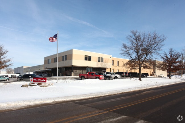
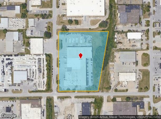
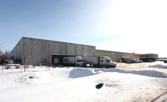
Property Record
1622 Ne 51St Ave, Des Moines, IA 50313
NEARBY LISTINGS FOR SALE OR LEASE
Property Detail
1622 Ne 51St Ave
Des Moines-West Des Moines, IA
Iowa Fund Inc Industrial Park Subdivisio
270-01666007005
E 84.4F W 1200F N405.73F S 1100F NW 1/4 SEC 13-79-24; AND -EX N 486F & W 90.6F S254.03F N 740.03F- LOT 8 IOWA FUND INC INDUSTRIAL PARK SUB DIV
Officebuilding
Polk
X
Iowa
19153C0215F
8
2024
7.54 AC
2025
Northeast
010500
Des Moines
99,727 SF
DEMOGRAPHICS near 1622 Ne 51St Ave
1 Mile
3 Mile
5 Mile
2024 Total Population
1,451
36,544
147,933
2029 Population
1,502
37,874
154,437
Pop Growth 2024-2029
+ 3.51%
+ 3.64%
+ 4.40%
Average Age
42
39
37
2024 Total Households
403
14,023
58,571
HH Growth 2024-2029
+ 3.47%
+ 3.84%
+ 4.64%
Median Household Inc
$68,017
$60,192
$60,793
Avg Household Size
2.30
2.40
2.40
2024 Avg HH Vehicles
2.00
2.00
2.00
Median Home Value
$218,636
$152,196
$170,966
Median Year Built
1960
1956
1966
Nearby Places
Map Layers
Map Styles
 Street
 Aerial
- Restaurants
- Banks
- Shops
- Fitness
- Groceries
PUBLIC TRANSPORTATION
AIRPORT
Des Moines International
DRIVE
WALK
Distance
Des Moines International
21 min
11.8 mi
Freight Ports
Port Milwaukee
DRIVE
WALK
Distance
Port Milwaukee
410 min
369.9 mi
Nearby Properties
Address
Land Use
TOTAL SIZE
Lot Size
Zoning
Address
Land Use
TOTAL SIZE
Lot Size
Zoning
481,030 SF
31.92 AC
PUD
Address
Land Use
TOTAL SIZE
Lot Size
Zoning
857,109 SF
73.97 AC
LI
Address
Land Use
TOTAL SIZE
Lot Size
Zoning
644,568 SF
29.90 AC
M-1
Address
Land Use
TOTAL SIZE
Lot Size
Zoning
675,000 SF
65.27 AC
Address
Land Use
TOTAL SIZE
Lot Size
Zoning
600,000 SF
40.15 AC
Address
Land Use
TOTAL SIZE
Lot Size
Zoning
463,530 SF
35.91 AC
M-1
Address
Land Use
TOTAL SIZE
Lot Size
Zoning
350,150 SF
35.34 AC
Address
Land Use
TOTAL SIZE
Lot Size
Zoning
274,300 SF
24.85 AC
Address
Land Use
TOTAL SIZE
Lot Size
Zoning
312,500 SF
38.14 AC
Address
Land Use
TOTAL SIZE
Lot Size
Zoning
263,250 SF
30.10 AC
M-1
Address
Land Use
TOTAL SIZE
Lot Size
Zoning
198,454 SF
12.04 AC
Address
Land Use
TOTAL SIZE
Lot Size
Zoning
300,000 SF
18.98 AC
Address
Land Use
TOTAL SIZE
Lot Size
Zoning
529,161 SF
33.60 AC
HI
Address
Land Use
TOTAL SIZE
Lot Size
Zoning
200,860 SF
11.25 AC
Address
Land Use
TOTAL SIZE
Lot Size
Zoning
126,935 SF
28.61 AC
Address
Land Use
TOTAL SIZE
Lot Size
Zoning
200,220 SF
15.61 AC
Address
Land Use
TOTAL SIZE
Lot Size
Zoning
130,496 SF
39.96 AC
HI
Address
Land Use
TOTAL SIZE
Lot Size
Zoning
275,000 SF
16.17 AC
HI
Address
Land Use
TOTAL SIZE
Lot Size
Zoning
603,502 SF
33.03 AC
M-1
Address
Land Use
TOTAL SIZE
Lot Size
Zoning
200,688 SF
20.26 AC
Address
Land Use
TOTAL SIZE
Lot Size
Zoning
220,740 SF
23.21 AC
Address
Land Use
TOTAL SIZE
Lot Size
Zoning
206,000 SF
19.12 AC
Address
Land Use
TOTAL SIZE
Lot Size
Zoning
1,838,971 SF
76.24 AC
HI
Address
Land Use
TOTAL SIZE
Lot Size
Zoning
82,202 SF
9.48 AC
PUD
Address
Land Use
TOTAL SIZE
Lot Size
Zoning
170,872 SF
25 AC
Address
Land Use
TOTAL SIZE
Lot Size
Zoning
184,320 SF
9.68 AC
Address
Land Use
TOTAL SIZE
Lot Size
Zoning
136,900 SF
28.82 AC
Address
Land Use
TOTAL SIZE
Lot Size
Zoning
180,000 SF
11.72 AC
Address
Land Use
TOTAL SIZE
Lot Size
Zoning
142,118 SF
10.59 AC
PUD
Address
Land Use
TOTAL SIZE
Lot Size
Zoning
162,240 SF
9.19 AC
The World's #1 Commercial Real Estate Marketplace
Connect with us
© 2025 CoStar Group
The information above has been obtained from sources believed reliable. While we do not doubt its accuracy we have not verified it and make no guarantee, warranty or representation about it. It is your responsibility to independently confirm its accuracy and completeness. Any projections, opinions, assumptions, or estimates used are for example only and do not represent the current or future performance of the property. The value of this transaction to you depends on tax and other factors which should be evaluated by your tax, financial, and legal advisors. You and your advisors should conduct a careful, independent investigation of the property to determine to your satisfaction the suitability of the property for your needs.