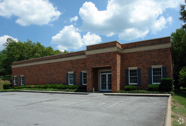
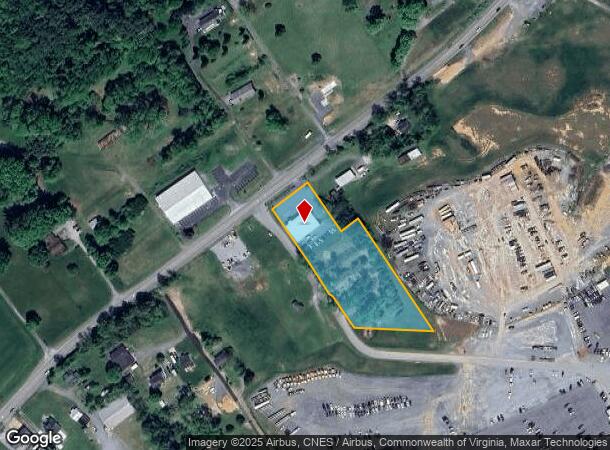
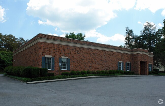
Property Record
16222 Lee Hwy, Bristol, VA 24202
NEARBY LISTINGS FOR SALE OR LEASE
Property Detail
16222 Lee Hwy
143A2-A-19A
MERCER LD YATES ACR 2.22
Taxexempt
Washington
X
Virginia
51191C0265C
2.22 AC
0
Washington County
2025
Kingsport/Bristol/Bristol
010101
Kingsport-Bristol-Bristol, TN-VA
6,045 SF
DEMOGRAPHICS near 16222 Lee Hwy
1 Mile
3 Mile
5 Mile
2024 Total Population
1,331
5,295
17,044
2029 Population
1,336
5,312
16,972
Pop Growth 2024-2029
+ 0.38%
+ 0.32%
(0.42%)
Average Age
45
45
45
2024 Total Households
582
2,256
7,357
HH Growth 2024-2029
+ 0.34%
+ 0.35%
(0.45%)
Median Household Inc
$54,200
$55,708
$61,924
Avg Household Size
2.30
2.30
2.30
2024 Avg HH Vehicles
2.00
2.00
2.00
Median Home Value
$172,543
$189,357
$199,664
Median Year Built
1992
1990
1984
Nearby Places
Map Layers
Map Styles
 Street
 Aerial
- Restaurants
- Banks
- Shops
- Fitness
- Groceries
PUBLIC TRANSPORTATION
AIRPORT
Tri-Cities
DRIVE
WALK
Distance
Tri-Cities
32 min
26.3 mi
Nearby Properties
Address
Land Use
TOTAL SIZE
Lot Size
Zoning
Address
Land Use
TOTAL SIZE
Lot Size
Zoning
3,626 SF
120.17 AC
A2 AGRICUL
Address
Land Use
TOTAL SIZE
Lot Size
Zoning
105,868 SF
0.34 AC
A2 AGRICUL
Address
Land Use
TOTAL SIZE
Lot Size
Zoning
8,696 SF
250.89 AC
A2 AGRICUL
Address
Land Use
TOTAL SIZE
Lot Size
Zoning
311,894 SF
17.16 AC
M1 INDUSTR
Address
Land Use
TOTAL SIZE
Lot Size
Zoning
166,980 SF
20.83 AC
B2 BUSINES
Address
Land Use
TOTAL SIZE
Lot Size
Zoning
87,952 SF
45.76 AC
M1 INDUSTR
Address
Land Use
TOTAL SIZE
Lot Size
Zoning
125,815 SF
31.42 AC
Address
Land Use
TOTAL SIZE
Lot Size
Zoning
126,432 SF
13.87 AC
B2 BUSINES
Address
Land Use
TOTAL SIZE
Lot Size
Zoning
13,618 SF
174.42 AC
R2 RESIDEN
Address
Land Use
TOTAL SIZE
Lot Size
Zoning
8,154 SF
73.47 AC
AD AIRPORT
Address
Land Use
TOTAL SIZE
Lot Size
Zoning
99,368 SF
16.95 AC
Address
Land Use
TOTAL SIZE
Lot Size
Zoning
586,376 SF
60 AC
M2 INDUSTR
Address
Land Use
TOTAL SIZE
Lot Size
Zoning
38,272 SF
6.82 AC
B2 BUSINES
Address
Land Use
TOTAL SIZE
Lot Size
Zoning
336,768 SF
43.21 AC
M1 INDUSTR
Address
Land Use
TOTAL SIZE
Lot Size
Zoning
69,100 SF
13.83 AC
M1 INDUSTR
Address
Land Use
TOTAL SIZE
Lot Size
Zoning
277,938 SF
37.99 AC
M2 INDUSTR
Address
Land Use
TOTAL SIZE
Lot Size
Zoning
22.36 AC
A2 AGRICUL
Address
Land Use
TOTAL SIZE
Lot Size
Zoning
1,008 SF
26.31 AC
M2 INDUSTR
Address
Land Use
TOTAL SIZE
Lot Size
Zoning
58,568 SF
15.09 AC
M1 INDUSTR
Address
Land Use
TOTAL SIZE
Lot Size
Zoning
15,822 SF
2.89 AC
B2 BUSINES
Address
Land Use
TOTAL SIZE
Lot Size
Zoning
11,000 SF
13.31 AC
B2 BUSINES
Address
Land Use
TOTAL SIZE
Lot Size
Zoning
20,906 SF
4.78 AC
B2 BUSINES
Address
Land Use
TOTAL SIZE
Lot Size
Zoning
105,732 SF
10.48 AC
M2 INDUSTR
Address
Land Use
TOTAL SIZE
Lot Size
Zoning
126,000 SF
8.59 AC
A2 AGRICUL
Address
Land Use
TOTAL SIZE
Lot Size
Zoning
1,320 SF
12.23 AC
B2 BUSINES
Address
Land Use
TOTAL SIZE
Lot Size
Zoning
302.10 AC
Address
Land Use
TOTAL SIZE
Lot Size
Zoning
25,360 SF
20.27 AC
M1 INDUSTR
Address
Land Use
TOTAL SIZE
Lot Size
Zoning
14,000 SF
3.55 AC
B2 BUSINES
Address
Land Use
TOTAL SIZE
Lot Size
Zoning
20,060 SF
113.99 AC
A2 AGRICUL
Address
Land Use
TOTAL SIZE
Lot Size
Zoning
1,800 SF
20 AC
M2 INDUSTR
The World's #1 Commercial Real Estate Marketplace
Connect with us
© 2026 CoStar Group
The information above has been obtained from sources believed reliable. While we do not doubt its accuracy we have not verified it and make no guarantee, warranty or representation about it. It is your responsibility to independently confirm its accuracy and completeness. Any projections, opinions, assumptions, or estimates used are for example only and do not represent the current or future performance of the property. The value of this transaction to you depends on tax and other factors which should be evaluated by your tax, financial, and legal advisors. You and your advisors should conduct a careful, independent investigation of the property to determine to your satisfaction the suitability of the property for your needs.