Property Record
16230 Truman Rd, Ellisville, MO 63011

NEARBY LISTINGS FOR SALE OR LEASE
-
-
View all Ellisville listings for sale on LoopNet.com
Property Detail
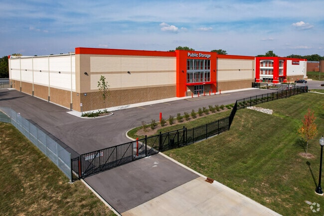
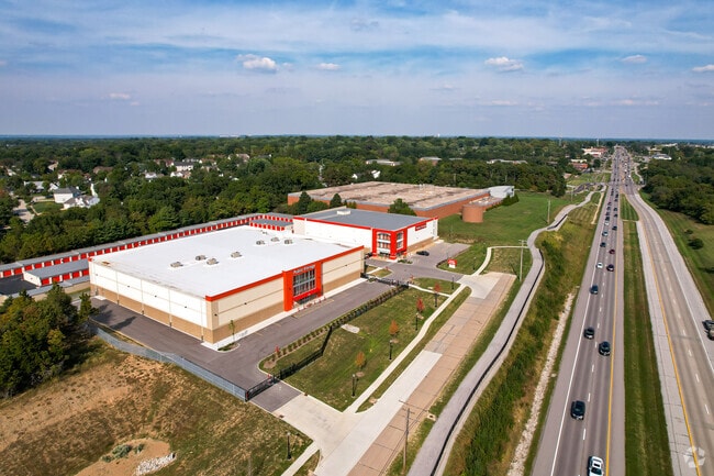
16230 Truman Rd
St. Louis, MO-IL
Paster Strecker Lot 2 Resub Lot 1 &
23U-61-0189
PASTER STRECKER LOT 2 RESUB LOT 1 & LOT PTS 2 & 3 CONSOLIDATION NEW LOT A LOT A
Warehouse
St. Louis
X
Missouri
29099C0025F
a
2024
8 AC
2025
West County
221624
St. Louis
185,087 SF
DEMOGRAPHICS near 16230 Truman Rd
1 Mile
3 Mile
5 Mile
2024 Total Population
8,623
51,691
109,895
2029 Population
8,344
50,470
107,333
Pop Growth 2024-2029
(3.24%)
(2.36%)
(2.33%)
Average Age
43
42
42
2024 Total Households
3,427
19,412
41,700
HH Growth 2024-2029
(3.27%)
(2.36%)
(2.33%)
Median Household Inc
$119,304
$121,446
$126,720
Avg Household Size
2.50
2.60
2.60
2024 Avg HH Vehicles
2.00
2.00
2.00
Median Home Value
$368,418
$373,952
$372,139
Median Year Built
1988
1986
1983
Nearby Places
Map Layers
Map Styles
 Street
 Aerial
- Restaurants
- Banks
- Shops
- Fitness
- Groceries
PUBLIC TRANSPORTATION
AIRPORT
St Louis Lambert International
DRIVE
WALK
Distance
St Louis Lambert International
42 min
26.8 mi
Nearby Properties
Address
Land Use
TOTAL SIZE
Lot Size
Zoning
Address
Land Use
TOTAL SIZE
Lot Size
Zoning
156,253 SF
10.64 AC
87PC
Address
Land Use
TOTAL SIZE
Lot Size
Zoning
70.42 AC
87A
Address
Land Use
TOTAL SIZE
Lot Size
Zoning
51.20 AC
NU
Address
Land Use
TOTAL SIZE
Lot Size
Zoning
85,946 SF
60.44 AC
NU
Address
Land Use
TOTAL SIZE
Lot Size
Zoning
313,104 SF
14.66 AC
MXD
Address
Land Use
TOTAL SIZE
Lot Size
Zoning
138,056 SF
17.42 AC
NU
Address
Land Use
TOTAL SIZE
Lot Size
Zoning
223,598 SF
13.95 AC
93C-1
Address
Land Use
TOTAL SIZE
Lot Size
Zoning
175,448 SF
6.95 AC
Address
Land Use
TOTAL SIZE
Lot Size
Zoning
111,719 SF
9.51 AC
19C-1
Address
Land Use
TOTAL SIZE
Lot Size
Zoning
247,992 SF
5.72 AC
C
Address
Land Use
TOTAL SIZE
Lot Size
Zoning
2,154 SF
13.19 AC
S
Address
Land Use
TOTAL SIZE
Lot Size
Zoning
7,900 SF
31.95 AC
87A
Address
Land Use
TOTAL SIZE
Lot Size
Zoning
191,316 SF
7.61 AC
R4
Address
Land Use
TOTAL SIZE
Lot Size
Zoning
181,790 SF
16.64 AC
R4
Address
Land Use
TOTAL SIZE
Lot Size
Zoning
16.80 AC
NU
Address
Land Use
TOTAL SIZE
Lot Size
Zoning
164,430 SF
9.85 AC
19C-4
Address
Land Use
TOTAL SIZE
Lot Size
Zoning
128,358 SF
12.01 AC
19C-3
Address
Land Use
TOTAL SIZE
Lot Size
Zoning
115,050 SF
12.46 AC
87C
Address
Land Use
TOTAL SIZE
Lot Size
Zoning
247,511 SF
31.03 AC
19M-1
Address
Land Use
TOTAL SIZE
Lot Size
Zoning
74,614 SF
8.05 AC
93C-1
Address
Land Use
TOTAL SIZE
Lot Size
Zoning
27.05 AC
R1
Address
Land Use
TOTAL SIZE
Lot Size
Zoning
82,686 SF
8.74 AC
C
Address
Land Use
TOTAL SIZE
Lot Size
Zoning
70,267 SF
11.61 AC
19C-3
Address
Land Use
TOTAL SIZE
Lot Size
Zoning
4,464 SF
12.30 AC
107NU
Address
Land Use
TOTAL SIZE
Lot Size
Zoning
7,250 SF
80.06 AC
R
Address
Land Use
TOTAL SIZE
Lot Size
Zoning
120,760 SF
11.10 AC
19C-3
Address
Land Use
TOTAL SIZE
Lot Size
Zoning
118,097 SF
14.32 AC
19C-4
Address
Land Use
TOTAL SIZE
Lot Size
Zoning
2,249 SF
8.94 AC
19R-1
Address
Land Use
TOTAL SIZE
Lot Size
Zoning
97,285 SF
13.66 AC
19R-1
The World's #1 Commercial Real Estate Marketplace
Connect with us
© 2026 CoStar Group
The information above has been obtained from sources believed reliable. While we do not doubt its accuracy we have not verified it and make no guarantee, warranty or representation about it. It is your responsibility to independently confirm its accuracy and completeness. Any projections, opinions, assumptions, or estimates used are for example only and do not represent the current or future performance of the property. The value of this transaction to you depends on tax and other factors which should be evaluated by your tax, financial, and legal advisors. You and your advisors should conduct a careful, independent investigation of the property to determine to your satisfaction the suitability of the property for your needs.