Property Record
16233 Fm Rd 624, Robstown, TX 78380

Save to a Folder
{{folder.Name}}
{{folder.ListingIds.length}} Properties
{{folder.ListingIds.length}} Property
Create a New Folder
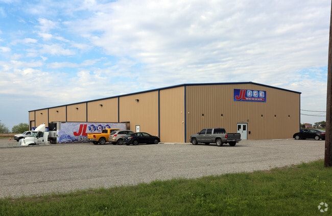
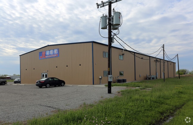
Property Detail
16233 Fm Rd 624
Corpus Christi, TX
WADE RIVERSIDE 2.53 ACS OUT SEC 4 AKA TR 9 & UNDIV INT IN CAROUSAL LANE
200080008
NUECES
Industrialgeneral
Texas
B and X Area of moderate flood hazard, usually the area between the limits of the 100-year and 500-year floods.
9
2025
2.71 AC
2025
Northwest
005804
Corpus Christi
16,030 SF
NEARBY LISTINGS FOR SALE OR LEASE
-
-
View all Robstown listings for sale on LoopNet.com
DEMOGRAPHICS near 16233 Fm Rd 624
1 mile
3 mile
5 mile
2025 Total Population
1,140
8,024
21,103
2030 Population
1,149
7,932
21,054
Pop Growth 2025-2030
+ 0.79%
(1.15%)
(0.23%)
Average Age
42
39
39
2025 Total Households
405
2,742
7,137
HH Growth 2025-2030
+ 0.74%
(1.35%)
(0.46%)
Median Household Inc
$79,018
$109,128
$79,550
Avg Household Size
2.80
2.90
2.90
2025 Avg HH Vehicles
3.00
2.00
2.00
Median Home Value
$295,412
$325,289
$240,167
Median Year Built
1986
1988
1982
Nearby Places
Map Layers
Map Styles
 Street
 Aerial
Layers
 Traffic
 Biking
Places
Listings with unknown addresses are not visible on the map
- Restaurants
- Banks
- Shops
- Fitness
- Groceries
PUBLIC TRANSPORTATION
AIRPORT
Corpus Christi International
Drive
Walk
Distance
Corpus Christi International
25 min
18.7 mi
Freight Ports
Port of Corpus Christi
Drive
Walk
Distance
Port of Corpus Christi
24 min
19.4 mi
Nearby Properties
Address
Land Use
TOTAL SIZE
Lot Size
Zoning
Address
Land Use
TOTAL SIZE
Lot Size
Zoning
68,975 SF
19.71 AC
Address
Land Use
TOTAL SIZE
Lot Size
Zoning
39,750 SF
5.89 AC
Address
Land Use
TOTAL SIZE
Lot Size
Zoning
65,877 SF
10.25 AC
R1B
Address
Land Use
TOTAL SIZE
Lot Size
Zoning
85,908 SF
10.25 AC
Address
Land Use
TOTAL SIZE
Lot Size
Zoning
36,523 SF
4.47 AC
B-4
Address
Land Use
TOTAL SIZE
Lot Size
Zoning
61,630 SF
33.70 AC
Address
Land Use
TOTAL SIZE
Lot Size
Zoning
25,852 SF
6.72 AC
FR
Address
Land Use
TOTAL SIZE
Lot Size
Zoning
27,525 SF
4.88 AC
Address
Land Use
TOTAL SIZE
Lot Size
Zoning
34,300 SF
3.47 AC
Address
Land Use
TOTAL SIZE
Lot Size
Zoning
43.49 AC
OCL
Address
Land Use
TOTAL SIZE
Lot Size
Zoning
25,694 SF
2.72 AC
B-4
Address
Land Use
TOTAL SIZE
Lot Size
Zoning
15,900 SF
2.89 AC
B-4
Address
Land Use
TOTAL SIZE
Lot Size
Zoning
35,200 SF
1.84 AC
Address
Land Use
TOTAL SIZE
Lot Size
Zoning
10,440 SF
1.41 AC
Address
Land Use
TOTAL SIZE
Lot Size
Zoning
1,156 SF
8 AC
Address
Land Use
TOTAL SIZE
Lot Size
Zoning
13,089 SF
1.12 AC
B-4
Address
Land Use
TOTAL SIZE
Lot Size
Zoning
400 SF
2.14 AC
B-4
Address
Land Use
TOTAL SIZE
Lot Size
Zoning
52,230 SF
2.23 AC
B4
Address
Land Use
TOTAL SIZE
Lot Size
Zoning
7,350 SF
2 AC
Address
Land Use
TOTAL SIZE
Lot Size
Zoning
20,843 SF
2.31 AC
B4
Address
Land Use
TOTAL SIZE
Lot Size
Zoning
6,192 SF
0.74 AC
Address
Land Use
TOTAL SIZE
Lot Size
Zoning
10,080 SF
2 AC
Address
Land Use
TOTAL SIZE
Lot Size
Zoning
8,790 SF
4.01 AC
R1B
Address
Land Use
TOTAL SIZE
Lot Size
Zoning
8.91 AC
R1B
Address
Land Use
TOTAL SIZE
Lot Size
Zoning
3,850 SF
1.11 AC
Address
Land Use
TOTAL SIZE
Lot Size
Zoning
12,272 SF
2.04 AC
B-4
Address
Land Use
TOTAL SIZE
Lot Size
Zoning
15,200 SF
1.70 AC
B-4
Address
Land Use
TOTAL SIZE
Lot Size
Zoning
11,300 SF
1.92 AC
B4
Address
Land Use
TOTAL SIZE
Lot Size
Zoning
7,009 SF
1.14 AC
B-4
Address
Land Use
TOTAL SIZE
Lot Size
Zoning
11,000 SF
2.49 AC
B-4
The World's #1 Commercial Real Estate Marketplace
Connect with us
© 2026 CoStar Group
The information above has been obtained from sources believed reliable. While we do not doubt its accuracy we have not verified it and make no guarantee, warranty or representation about it. It is your responsibility to independently confirm its accuracy and completeness. Any projections, opinions, assumptions, or estimates used are for example only and do not represent the current or future performance of the property. The value of this transaction to you depends on tax and other factors which should be evaluated by your tax, financial, and legal advisors. You and your advisors should conduct a careful, independent investigation of the property to determine to your satisfaction the suitability of the property for your needs.