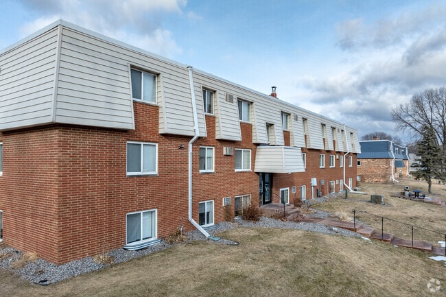
Property Record
1624 10Th Ave, Newport, MN 55055
NEARBY LISTINGS FOR SALE OR LEASE
-
-
View all Newport listings for sale on LoopNet.com
Property Detail
1624 10Th Ave
Minneapolis-St. Paul-Bloomington, MN-WI
Newport Acres
36-028-22-21-0018
PART LOT 2&3
Apartment
Washington
X
Minnesota
27037C0150E
16
2025
0.74 AC
2024
Newport
071003
Minneapolis/St Paul
9,440 SF
DEMOGRAPHICS near 1624 10Th Ave
1 Mile
3 Mile
5 Mile
2024 Total Population
4,259
55,938
164,642
2029 Population
4,718
58,872
173,456
Pop Growth 2024-2029
+ 10.78%
+ 5.25%
+ 5.35%
Average Age
39
40
39
2024 Total Households
1,643
21,596
62,883
HH Growth 2024-2029
+ 11.02%
+ 5.27%
+ 5.22%
Median Household Inc
$68,571
$84,254
$88,468
Avg Household Size
2.60
2.50
2.60
2024 Avg HH Vehicles
2.00
2.00
2.00
Median Home Value
$390,329
$290,922
$316,370
Median Year Built
1978
1981
1984
Nearby Places
Map Layers
Map Styles
 Street
 Aerial
- Restaurants
- Banks
- Shops
- Fitness
- Groceries
PUBLIC TRANSPORTATION
COMMUTER RAIL
St. Paul-Minneapolis (Empire Builder - Amtrak)
DRIVE
WALK
Distance
St. Paul-Minneapolis (Empire Builder - Amtrak)
11 min
8.8 mi
AIRPORT
Minneapolis-St Paul International/Wold-Chamberlain
DRIVE
WALK
Distance
Minneapolis-St Paul International/Wold-Chamberlain
22 min
13.9 mi
Freight Ports
Port Milwaukee
DRIVE
WALK
Distance
Port Milwaukee
361 min
328.3 mi
Nearby Properties
Address
Land Use
TOTAL SIZE
Lot Size
Zoning
Address
Land Use
TOTAL SIZE
Lot Size
Zoning
244,431 SF
Address
Land Use
TOTAL SIZE
Lot Size
Zoning
243,476 SF
14.87 AC
Address
Land Use
TOTAL SIZE
Lot Size
Zoning
3.63 AC
Address
Land Use
TOTAL SIZE
Lot Size
Zoning
5.77 AC
Address
Land Use
TOTAL SIZE
Lot Size
Zoning
196,078 SF
31.29 AC
Address
Land Use
TOTAL SIZE
Lot Size
Zoning
228,050 SF
0.32 AC
Address
Land Use
TOTAL SIZE
Lot Size
Zoning
230,892 SF
43.62 AC
Address
Land Use
TOTAL SIZE
Lot Size
Zoning
71,164 SF
10.79 AC
Address
Land Use
TOTAL SIZE
Lot Size
Zoning
163,985 SF
7.06 AC
Address
Land Use
TOTAL SIZE
Lot Size
Zoning
169,237 SF
23.38 AC
Address
Land Use
TOTAL SIZE
Lot Size
Zoning
186,856 SF
Address
Land Use
TOTAL SIZE
Lot Size
Zoning
452,836 SF
17.81 AC
Address
Land Use
TOTAL SIZE
Lot Size
Zoning
Address
Land Use
TOTAL SIZE
Lot Size
Zoning
138,609 SF
3.76 AC
Address
Land Use
TOTAL SIZE
Lot Size
Zoning
106,894 SF
5.88 AC
Address
Land Use
TOTAL SIZE
Lot Size
Zoning
41,040 SF
11.38 AC
Address
Land Use
TOTAL SIZE
Lot Size
Zoning
50,246 SF
4.21 AC
Address
Land Use
TOTAL SIZE
Lot Size
Zoning
94,822 SF
34.92 AC
Address
Land Use
TOTAL SIZE
Lot Size
Zoning
123,226 SF
9.50 AC
Address
Land Use
TOTAL SIZE
Lot Size
Zoning
150,469 SF
10.73 AC
Address
Land Use
TOTAL SIZE
Lot Size
Zoning
152,098 SF
8.23 AC
Address
Land Use
TOTAL SIZE
Lot Size
Zoning
28,461 SF
16.13 AC
Address
Land Use
TOTAL SIZE
Lot Size
Zoning
70,987 SF
8.88 AC
Address
Land Use
TOTAL SIZE
Lot Size
Zoning
151,959 SF
0.32 AC
Address
Land Use
TOTAL SIZE
Lot Size
Zoning
219,438 SF
90.20 AC
Address
Land Use
TOTAL SIZE
Lot Size
Zoning
111,334 SF
38.36 AC
Address
Land Use
TOTAL SIZE
Lot Size
Zoning
143,712 SF
9.57 AC
Address
Land Use
TOTAL SIZE
Lot Size
Zoning
290,362 SF
12.83 AC
Address
Land Use
TOTAL SIZE
Lot Size
Zoning
161,676 SF
13.90 AC
Address
Land Use
TOTAL SIZE
Lot Size
Zoning
95,693 SF
3.64 AC
The World's #1 Commercial Real Estate Marketplace
Connect with us
© 2025 CoStar Group
The information above has been obtained from sources believed reliable. While we do not doubt its accuracy we have not verified it and make no guarantee, warranty or representation about it. It is your responsibility to independently confirm its accuracy and completeness. Any projections, opinions, assumptions, or estimates used are for example only and do not represent the current or future performance of the property. The value of this transaction to you depends on tax and other factors which should be evaluated by your tax, financial, and legal advisors. You and your advisors should conduct a careful, independent investigation of the property to determine to your satisfaction the suitability of the property for your needs.