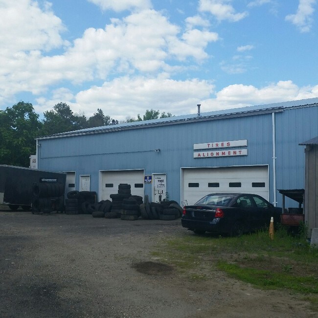
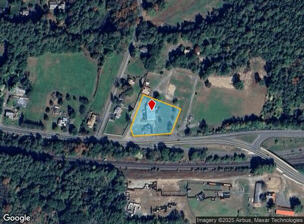
Property Record
1624 Park St, Palmer, MA 01069

NEARBY LISTINGS FOR SALE OR LEASE
Property Detail
1624 Park St
PALM-000002-000000-000078
Hampden
Commercialnec
Massachusetts
X
1.24 AC
25013C0268E
Hampden County
2025
Hartford
2025
Springfield, MA
810100
DEMOGRAPHICS near 1624 Park St
1 Mile
3 Mile
5 Mile
2024 Total Population
855
7,327
18,422
2029 Population
840
7,203
18,019
Pop Growth 2024-2029
(1.75%)
(1.69%)
(2.19%)
Average Age
44
44
44
2024 Total Households
341
3,185
7,907
HH Growth 2024-2029
(1.76%)
(1.73%)
(2.25%)
Median Household Inc
$72,499
$61,805
$68,676
Avg Household Size
2.50
2.30
2.30
2024 Avg HH Vehicles
2.00
2.00
2.00
Median Home Value
$312,736
$268,401
$269,411
Median Year Built
1979
1968
1968
Nearby Places
Map Layers
Map Styles
 Street
 Aerial
- Restaurants
- Banks
- Shops
- Fitness
- Groceries
PUBLIC TRANSPORTATION
AIRPORT
Worcester Regional
DRIVE
WALK
Distance
Worcester Regional
53 min
34.0 mi
Bradley International
DRIVE
WALK
Distance
Bradley International
61 min
34.7 mi
Freight Ports
Port of Davisville, RI
DRIVE
WALK
Distance
Port of Davisville, RI
111 min
85.2 mi
SALE & LEASE HISTORY
LISTING DATE
SALE/LEASE

Jun 01, 2018
For Sale
Nearby Properties
Address
Land Use
TOTAL SIZE
Lot Size
Zoning
Address
Land Use
TOTAL SIZE
Lot Size
Zoning
674.33 AC
RR
Address
Land Use
TOTAL SIZE
Lot Size
Zoning
112,556 SF
20 AC
RR
Address
Land Use
TOTAL SIZE
Lot Size
Zoning
91,544 SF
18.47 AC
RV
Address
Land Use
TOTAL SIZE
Lot Size
Zoning
85,228 SF
46.53 AC
RV
Address
Land Use
TOTAL SIZE
Lot Size
Zoning
255.28 AC
RR
Address
Land Use
TOTAL SIZE
Lot Size
Zoning
50,656 SF
5.62 AC
I
Address
Land Use
TOTAL SIZE
Lot Size
Zoning
10,080 SF
1.53 AC
VC1
Address
Land Use
TOTAL SIZE
Lot Size
Zoning
22.57 AC
I
Address
Land Use
TOTAL SIZE
Lot Size
Zoning
714 AC
AR
Address
Land Use
TOTAL SIZE
Lot Size
Zoning
84,748 SF
2 AC
HB
Address
Land Use
TOTAL SIZE
Lot Size
Zoning
0.92 AC
SR
Address
Land Use
TOTAL SIZE
Lot Size
Zoning
8.96 AC
IA
Address
Land Use
TOTAL SIZE
Lot Size
Zoning
152.05 AC
HB
Address
Land Use
TOTAL SIZE
Lot Size
Zoning
53.88 AC
RR
Address
Land Use
TOTAL SIZE
Lot Size
Zoning
47,712 SF
3.59 AC
HB
Address
Land Use
TOTAL SIZE
Lot Size
Zoning
301 AC
RR
Address
Land Use
TOTAL SIZE
Lot Size
Zoning
10,716 SF
0.31 AC
VC1
Address
Land Use
TOTAL SIZE
Lot Size
Zoning
75.29 AC
RR
Address
Land Use
TOTAL SIZE
Lot Size
Zoning
23,480 SF
2.06 AC
VC1
Address
Land Use
TOTAL SIZE
Lot Size
Zoning
106,171 SF
4.03 AC
IA
Address
Land Use
TOTAL SIZE
Lot Size
Zoning
40,964 SF
3.30 AC
IA
Address
Land Use
TOTAL SIZE
Lot Size
Zoning
8.08 AC
IA
Address
Land Use
TOTAL SIZE
Lot Size
Zoning
8,192 SF
0.52 AC
TR
Address
Land Use
TOTAL SIZE
Lot Size
Zoning
12,136 SF
12.34 AC
GB
Address
Land Use
TOTAL SIZE
Lot Size
Zoning
86,990 SF
1.05 AC
IA
Address
Land Use
TOTAL SIZE
Lot Size
Zoning
48,750 SF
24.38 AC
I
Address
Land Use
TOTAL SIZE
Lot Size
Zoning
67.50 AC
AR
Address
Land Use
TOTAL SIZE
Lot Size
Zoning
0.65 AC
TR
Address
Land Use
TOTAL SIZE
Lot Size
Zoning
1.30 AC
HB
Address
Land Use
TOTAL SIZE
Lot Size
Zoning
23.04 AC
IA
The World's #1 Commercial Real Estate Marketplace
Connect with us
© 2025 CoStar Group
The information above has been obtained from sources believed reliable. While we do not doubt its accuracy we have not verified it and make no guarantee, warranty or representation about it. It is your responsibility to independently confirm its accuracy and completeness. Any projections, opinions, assumptions, or estimates used are for example only and do not represent the current or future performance of the property. The value of this transaction to you depends on tax and other factors which should be evaluated by your tax, financial, and legal advisors. You and your advisors should conduct a careful, independent investigation of the property to determine to your satisfaction the suitability of the property for your needs.