Property Record
1625 Annafeld Pkwy E, Billings, MT 59101


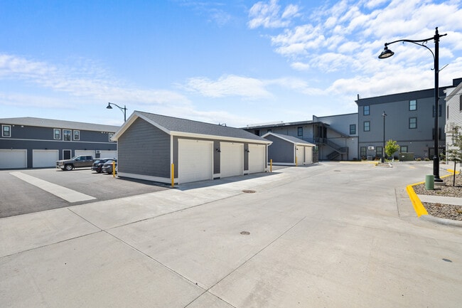
This Property Is For Sale
NEARBY LISTINGS FOR SALE OR LEASE
-
-
View all Billings listings for sale on LoopNet.com
Property Detail
1625 Annafeld Pkwy E
Billings, MT
Annafeld Sub 3Rd Fil (22)
03-0927-19-2-12-01-0000
ANNAFELD SUB 3RD FIL (22), S19, T01 S, R26 E, BLOCK 10, LOT 1
Multifamilydwelling
Yellowstone
X
Montana
30111C1455E
1
2024
0.19 AC
2025
Billings
001404
Other Market Areas
15,360 SF
DEMOGRAPHICS near 1625 Annafeld Pkwy E
1 Mile
3 Mile
5 Mile
2024 Total Population
2,363
41,244
98,193
2029 Population
2,651
46,037
109,548
Pop Growth 2024-2029
+ 12.19%
+ 11.62%
+ 11.56%
Average Age
39
40
41
2024 Total Households
1,056
18,035
42,575
HH Growth 2024-2029
+ 12.69%
+ 12.13%
+ 12.11%
Median Household Inc
$76,231
$61,753
$67,078
Avg Household Size
2.20
2.20
2.20
2024 Avg HH Vehicles
2.00
2.00
2.00
Median Home Value
$378,427
$306,130
$348,762
Median Year Built
2005
1982
1976
Nearby Places
Map Layers
Map Styles
 Street
 Aerial
- Restaurants
- Banks
- Shops
- Fitness
- Groceries
PUBLIC TRANSPORTATION
AIRPORT
Billings Logan International
DRIVE
WALK
Distance
Billings Logan International
29 min
10.4 mi
Freight Ports
Port of Everett
DRIVE
WALK
Distance
Port of Everett
881 min
837.2 mi
Nearby Properties
Address
Land Use
TOTAL SIZE
Lot Size
Zoning
Address
Land Use
TOTAL SIZE
Lot Size
Zoning
145.51 AC
Address
Land Use
TOTAL SIZE
Lot Size
Zoning
164,242 SF
33.08 AC
P
Address
Land Use
TOTAL SIZE
Lot Size
Zoning
136,588 SF
21.01 AC
CI
Address
Land Use
TOTAL SIZE
Lot Size
Zoning
188,030 SF
13.88 AC
A-1
Address
Land Use
TOTAL SIZE
Lot Size
Zoning
259,684 SF
14.73 AC
Address
Land Use
TOTAL SIZE
Lot Size
Zoning
116,250 SF
9.39 AC
Address
Land Use
TOTAL SIZE
Lot Size
Zoning
156,883 SF
12.86 AC
Address
Land Use
TOTAL SIZE
Lot Size
Zoning
70,034 SF
7.29 AC
Address
Land Use
TOTAL SIZE
Lot Size
Zoning
77.63 AC
Address
Land Use
TOTAL SIZE
Lot Size
Zoning
537,468 SF
36.83 AC
CC
Address
Land Use
TOTAL SIZE
Lot Size
Zoning
173,807 SF
11.56 AC
CI
Address
Land Use
TOTAL SIZE
Lot Size
Zoning
156.04 AC
Address
Land Use
TOTAL SIZE
Lot Size
Zoning
16,656 SF
10.85 AC
Address
Land Use
TOTAL SIZE
Lot Size
Zoning
218,478 SF
18.19 AC
CI
Address
Land Use
TOTAL SIZE
Lot Size
Zoning
109,467 SF
5.97 AC
Address
Land Use
TOTAL SIZE
Lot Size
Zoning
13,216 SF
144.80 AC
A-1
Address
Land Use
TOTAL SIZE
Lot Size
Zoning
172.22 AC
Address
Land Use
TOTAL SIZE
Lot Size
Zoning
177,290 SF
14.59 AC
HC
Address
Land Use
TOTAL SIZE
Lot Size
Zoning
151,056 SF
49.20 AC
A-1
Address
Land Use
TOTAL SIZE
Lot Size
Zoning
1,200 SF
57.17 AC
P
Address
Land Use
TOTAL SIZE
Lot Size
Zoning
409,620 SF
27.42 AC
CI
Address
Land Use
TOTAL SIZE
Lot Size
Zoning
168,560 SF
24.67 AC
Address
Land Use
TOTAL SIZE
Lot Size
Zoning
67.17 AC
Address
Land Use
TOTAL SIZE
Lot Size
Zoning
109,485 SF
8.87 AC
R-96
Address
Land Use
TOTAL SIZE
Lot Size
Zoning
167,744 SF
16.45 AC
CI
Address
Land Use
TOTAL SIZE
Lot Size
Zoning
7,538 SF
59.81 AC
A-1
Address
Land Use
TOTAL SIZE
Lot Size
Zoning
127,408 SF
7.98 AC
A-1
Address
Land Use
TOTAL SIZE
Lot Size
Zoning
38,313 SF
3.27 AC
Address
Land Use
TOTAL SIZE
Lot Size
Zoning
86,332 SF
11.18 AC
Address
Land Use
TOTAL SIZE
Lot Size
Zoning
178,736 SF
11.94 AC
HC
The World's #1 Commercial Real Estate Marketplace
Connect with us
© 2026 CoStar Group
The information above has been obtained from sources believed reliable. While we do not doubt its accuracy we have not verified it and make no guarantee, warranty or representation about it. It is your responsibility to independently confirm its accuracy and completeness. Any projections, opinions, assumptions, or estimates used are for example only and do not represent the current or future performance of the property. The value of this transaction to you depends on tax and other factors which should be evaluated by your tax, financial, and legal advisors. You and your advisors should conduct a careful, independent investigation of the property to determine to your satisfaction the suitability of the property for your needs.