Property Record
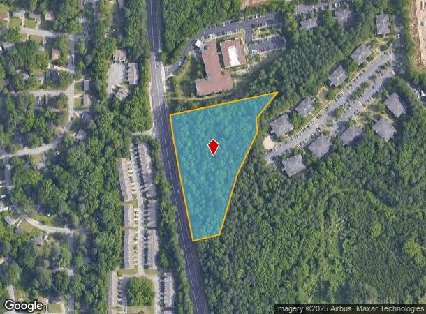
1625 James Jackson Pkwy Nw, Atlanta, GA 30318
This Property Is For Sale
NEARBY LISTINGS FOR SALE OR LEASE
Property Detail
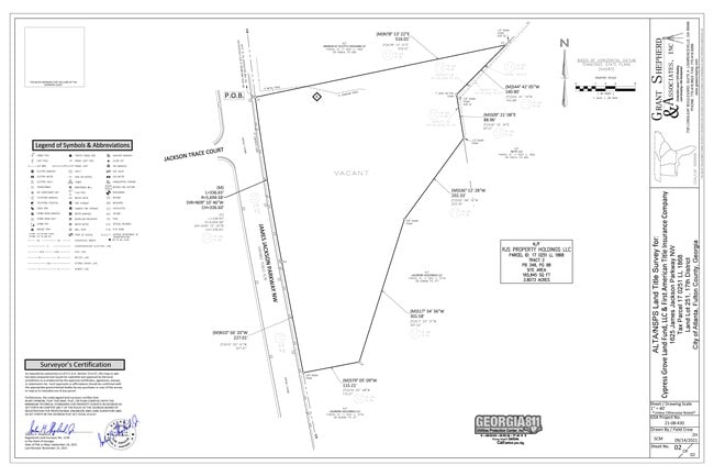
1625 James Jackson Pkwy Nw
17-0251-LL-186-8
KA VACANT LAND FLD CK 3/22/22 SALES VALIDATED UPDATE PARCEL** CB23 VERIFY LAND USE FLD CK 7/6/22; RMV SP OVRR ** NO CHG
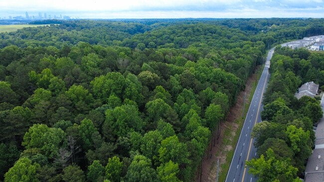
Commercialacreage
Fulton
X
Georgia
13121C0236F
3.80 AC
2024
West Atlanta
2025
Atlanta
008701
Atlanta-Sandy Springs-Roswell, GA
DEMOGRAPHICS near 1625 James Jackson Pkwy Nw
1 Mile
3 Mile
5 Mile
2024 Total Population
8,240
67,266
234,893
2029 Population
8,661
72,808
247,301
Pop Growth 2024-2029
+ 5.11%
+ 8.24%
+ 5.28%
Average Age
34
37
37
2024 Total Households
3,256
28,264
100,704
HH Growth 2024-2029
+ 5.07%
+ 7.94%
+ 5.31%
Median Household Inc
$44,855
$69,886
$72,558
Avg Household Size
2.40
2.30
2.10
2024 Avg HH Vehicles
1.00
1.00
1.00
Median Home Value
$288,493
$327,059
$369,897
Median Year Built
1975
1998
1993
Nearby Places
- Restaurants
- Banks
- Shops
- Fitness
- Groceries
PUBLIC TRANSPORTATION
COMMUTER RAIL
DRIVE
WALK
Distance
16 min
7.0 mi
AIRPORT
Hartsfield - Jackson Atlanta International
DRIVE
WALK
Distance
Hartsfield - Jackson Atlanta International
27 min
16.6 mi
Nearby Properties
Address
Land Use
TOTAL SIZE
Lot Size
Zoning
Address
Land Use
TOTAL SIZE
Lot Size
Zoning
485,185 SF
3.76 AC
I2
Address
Land Use
TOTAL SIZE
Lot Size
Zoning
467,671 SF
4.82 AC
C1
Address
Land Use
TOTAL SIZE
Lot Size
Zoning
520,886 SF
9.96 AC
I2
Address
Land Use
TOTAL SIZE
Lot Size
Zoning
354,766 SF
11.32 AC
RG3
Address
Land Use
TOTAL SIZE
Lot Size
Zoning
549,094 SF
6.26 AC
I2
Address
Land Use
TOTAL SIZE
Lot Size
Zoning
3.25 AC
MU
Address
Land Use
TOTAL SIZE
Lot Size
Zoning
695,481 SF
11.66 AC
RG3
Address
Land Use
TOTAL SIZE
Lot Size
Zoning
354,710 SF
25.27 AC
R5
Address
Land Use
TOTAL SIZE
Lot Size
Zoning
115 AC
I2
Address
Land Use
TOTAL SIZE
Lot Size
Zoning
329,385 SF
15.29 AC
RHR
Address
Land Use
TOTAL SIZE
Lot Size
Zoning
1,151,446 SF
I2
Address
Land Use
TOTAL SIZE
Lot Size
Zoning
439,167 SF
41.13 AC
RM-12
Address
Land Use
TOTAL SIZE
Lot Size
Zoning
281,632 SF
27.12 AC
RM-12
Address
Land Use
TOTAL SIZE
Lot Size
Zoning
538,535 SF
32.40 AC
I2
Address
Land Use
TOTAL SIZE
Lot Size
Zoning
499,198 SF
9.49 AC
RG3
Address
Land Use
TOTAL SIZE
Lot Size
Zoning
415,834 SF
17.62 AC
I2
Address
Land Use
TOTAL SIZE
Lot Size
Zoning
563,551 SF
13.98 AC
RG2C
Address
Land Use
TOTAL SIZE
Lot Size
Zoning
1,057,380 SF
17.43 AC
C1
Address
Land Use
TOTAL SIZE
Lot Size
Zoning
59.28 AC
I1
Address
Land Use
TOTAL SIZE
Lot Size
Zoning
263,676 SF
15.70 AC
RM-12
Address
Land Use
TOTAL SIZE
Lot Size
Zoning
68.38 AC
R2
Address
Land Use
TOTAL SIZE
Lot Size
Zoning
285.03 AC
I2
Address
Land Use
TOTAL SIZE
Lot Size
Zoning
19.31 AC
R4
Address
Land Use
TOTAL SIZE
Lot Size
Zoning
884,316 SF
5.84 AC
I1
Address
Land Use
TOTAL SIZE
Lot Size
Zoning
147,333 SF
2.29 AC
RG3
Address
Land Use
TOTAL SIZE
Lot Size
Zoning
694,436 SF
36.80 AC
HI
Address
Land Use
TOTAL SIZE
Lot Size
Zoning
2,356,020 SF
17.53 AC
RG3
Address
Land Use
TOTAL SIZE
Lot Size
Zoning
251,706 SF
20.22 AC
RM-12
Address
Land Use
TOTAL SIZE
Lot Size
Zoning
266,871 SF
10.60 AC
I2
Address
Land Use
TOTAL SIZE
Lot Size
Zoning
237,515 SF
16.68 AC
C2
The World's #1 Commercial Real Estate Marketplace
Connect with us
© 2025 CoStar Group
The information above has been obtained from sources believed reliable. While we do not doubt its accuracy we have not verified it and make no guarantee, warranty or representation about it. It is your responsibility to independently confirm its accuracy and completeness. Any projections, opinions, assumptions, or estimates used are for example only and do not represent the current or future performance of the property. The value of this transaction to you depends on tax and other factors which should be evaluated by your tax, financial, and legal advisors. You and your advisors should conduct a careful, independent investigation of the property to determine to your satisfaction the suitability of the property for your needs.