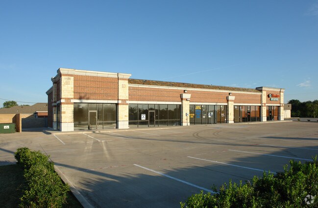
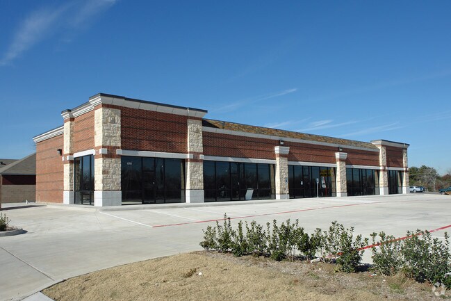
Property Record
1625 S Belt Line Rd, Grand Prairie, TX 75051

NEARBY LISTINGS FOR SALE OR LEASE
Property Detail
1625 S Belt Line Rd
Dallas-Fort Worth-Arlington, TX
Belt Line Crossing
28009540010010000
BELT LINE CROSSING BLK 1 LT 1 ACS 0.650 INT20070276365 DD07182007 CO-DC 0095400100100 2CP00954001
Stripcommercialcenter
Dallas
X
Texas
48113C0455M
1
2024
0.65 AC
2025
North Grand Prairie
016201
Dallas/Ft Worth
6,576 SF
DEMOGRAPHICS near 1625 S Belt Line Rd
1 Mile
3 Mile
5 Mile
2024 Total Population
15,543
80,039
194,611
2029 Population
15,289
79,322
196,454
Pop Growth 2024-2029
(1.63%)
(0.90%)
+ 0.95%
Average Age
34
35
35
2024 Total Households
4,489
25,087
63,219
HH Growth 2024-2029
(1.89%)
(1.11%)
+ 0.96%
Median Household Inc
$56,500
$55,375
$58,348
Avg Household Size
3.40
3.10
3.00
2024 Avg HH Vehicles
2.00
2.00
2.00
Median Home Value
$172,321
$171,987
$209,365
Median Year Built
1974
1976
1982
Nearby Places
Map Layers
Map Styles
 Street
 Aerial
- Restaurants
- Banks
- Shops
- Fitness
- Groceries
PUBLIC TRANSPORTATION
COMMUTER RAIL
West Irving (Trinity Railway Express - Dallas Area Rapid Transit (DART))
DRIVE
WALK
Distance
West Irving (Trinity Railway Express - Dallas Area Rapid Transit (DART))
16 min
7.5 mi
DRIVE
WALK
Distance
13 min
8.9 mi
AIRPORT
Dallas-Fort Worth International
DRIVE
WALK
Distance
Dallas-Fort Worth International
24 min
16.2 mi
Dallas Love Field
DRIVE
WALK
Distance
Dallas Love Field
30 min
16.6 mi
Nearby Properties
Address
Land Use
TOTAL SIZE
Lot Size
Zoning
Address
Land Use
TOTAL SIZE
Lot Size
Zoning
2,395,314 SF
152.04 AC
Address
Land Use
TOTAL SIZE
Lot Size
Zoning
1,306,700 SF
87.99 AC
Address
Land Use
TOTAL SIZE
Lot Size
Zoning
459,985 SF
179.23 AC
Z06
Address
Land Use
TOTAL SIZE
Lot Size
Zoning
1,577,320 SF
122.55 AC
Z123
Address
Land Use
TOTAL SIZE
Lot Size
Zoning
860,445 SF
50.39 AC
Z123
Address
Land Use
TOTAL SIZE
Lot Size
Zoning
334,057 SF
20.05 AC
Z312
Address
Land Use
TOTAL SIZE
Lot Size
Zoning
753,721 SF
42.65 AC
Address
Land Use
TOTAL SIZE
Lot Size
Zoning
358,350 SF
13.15 AC
Address
Land Use
TOTAL SIZE
Lot Size
Zoning
247,880 SF
20.93 AC
Z236
Address
Land Use
TOTAL SIZE
Lot Size
Zoning
1,054,767 SF
37.45 AC
Z123
Address
Land Use
TOTAL SIZE
Lot Size
Zoning
603,000 SF
32.80 AC
Z123
Address
Land Use
TOTAL SIZE
Lot Size
Zoning
252,800 SF
21.59 AC
Z236
Address
Land Use
TOTAL SIZE
Lot Size
Zoning
264,010 SF
34.50 AC
Z190
Address
Land Use
TOTAL SIZE
Lot Size
Zoning
228,210 SF
12.28 AC
Z190
Address
Land Use
TOTAL SIZE
Lot Size
Zoning
283,087 SF
15.22 AC
Z236
Address
Land Use
TOTAL SIZE
Lot Size
Zoning
436,343 SF
5.36 AC
Z236
Address
Land Use
TOTAL SIZE
Lot Size
Zoning
150,000 SF
12.95 AC
Address
Land Use
TOTAL SIZE
Lot Size
Zoning
77,020 SF
22.82 AC
Address
Land Use
TOTAL SIZE
Lot Size
Zoning
83,938 SF
22.46 AC
Address
Land Use
TOTAL SIZE
Lot Size
Zoning
436,014 SF
47.53 AC
Z236
Address
Land Use
TOTAL SIZE
Lot Size
Zoning
746,852 SF
34.91 AC
Address
Land Use
TOTAL SIZE
Lot Size
Zoning
158,430 SF
4.42 AC
Z97
Address
Land Use
TOTAL SIZE
Lot Size
Zoning
346,500 SF
18.75 AC
Z236
Address
Land Use
TOTAL SIZE
Lot Size
Zoning
392,220 SF
24.55 AC
Z102
Address
Land Use
TOTAL SIZE
Lot Size
Zoning
698,880 SF
32.52 AC
Address
Land Use
TOTAL SIZE
Lot Size
Zoning
84,600 SF
9.44 AC
Z236
Address
Land Use
TOTAL SIZE
Lot Size
Zoning
210,000 SF
13.93 AC
Address
Land Use
TOTAL SIZE
Lot Size
Zoning
310,047 SF
16.40 AC
Z236
Address
Land Use
TOTAL SIZE
Lot Size
Zoning
289,445 SF
29.62 AC
Z313
Address
Land Use
TOTAL SIZE
Lot Size
Zoning
257,448 SF
13.45 AC
Z190
The World's #1 Commercial Real Estate Marketplace
Connect with us
© 2025 CoStar Group
The information above has been obtained from sources believed reliable. While we do not doubt its accuracy we have not verified it and make no guarantee, warranty or representation about it. It is your responsibility to independently confirm its accuracy and completeness. Any projections, opinions, assumptions, or estimates used are for example only and do not represent the current or future performance of the property. The value of this transaction to you depends on tax and other factors which should be evaluated by your tax, financial, and legal advisors. You and your advisors should conduct a careful, independent investigation of the property to determine to your satisfaction the suitability of the property for your needs.