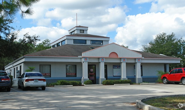
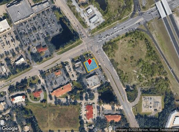
Property Record
1625 Taylor Rd, Port Orange, FL 32128

NEARBY LISTINGS FOR SALE OR LEASE
Property Detail
1625 Taylor Rd
6319-00-00-0192
Parcel
Parkinglot
19-16-33 PARCEL IN NE 1/4 BEING N 175 FT OF E 175 FT S OF TAYLOR RD & W OF SERVICE RD EXC NEW R/W BEING E 34.40 FT ON N/L & E 12.38 FT ON S/L PER OR 3926 PG 4236 PER OR 5311 PGS 0401-0402 PER OR 5311 PGS 0408-0409 PER OR 6303 PGS 0728-0733 INC PER OR
X
Volusia
12127C0506H
Florida
2025
0.61 AC
2025
South Beach Cities
083210
Deltona/Daytona Beach
3,959 SF
Deltona-Daytona Beach-Ormond Beach, FL
DEMOGRAPHICS near 1625 Taylor Rd
1 Mile
3 Mile
5 Mile
2024 Total Population
6,601
52,003
103,432
2029 Population
7,261
57,356
114,533
Pop Growth 2024-2029
+ 10.00%
+ 10.29%
+ 10.73%
Average Age
45
45
46
2024 Total Households
2,926
22,460
45,623
HH Growth 2024-2029
+ 10.15%
+ 10.49%
+ 11.16%
Median Household Inc
$75,364
$62,700
$56,928
Avg Household Size
2.20
2.30
2.20
2024 Avg HH Vehicles
2.00
2.00
2.00
Median Home Value
$285,204
$257,523
$244,429
Median Year Built
2000
1989
1986
Nearby Places
Map Layers
Map Styles
 Street
 Aerial
- Restaurants
- Banks
- Shops
- Fitness
- Groceries
PUBLIC TRANSPORTATION
AIRPORT
Daytona Beach International
DRIVE
WALK
Distance
Daytona Beach International
14 min
7.9 mi
Orlando Sanford International
DRIVE
WALK
Distance
Orlando Sanford International
49 min
31.4 mi
Freight Ports
Port Canaveral
DRIVE
WALK
Distance
Port Canaveral
74 min
64.0 mi
Nearby Properties
Address
Land Use
TOTAL SIZE
Lot Size
Zoning
Address
Land Use
TOTAL SIZE
Lot Size
Zoning
481,883 SF
0.10 AC
Address
Land Use
TOTAL SIZE
Lot Size
Zoning
33,958 SF
190.21 AC
A2
Address
Land Use
TOTAL SIZE
Lot Size
Zoning
490,775 SF
34.26 AC
01MH1
Address
Land Use
TOTAL SIZE
Lot Size
Zoning
354,546 SF
24.71 AC
Address
Land Use
TOTAL SIZE
Lot Size
Zoning
448,867 SF
5.54 AC
Address
Land Use
TOTAL SIZE
Lot Size
Zoning
416,320 SF
0.13 AC
Address
Land Use
TOTAL SIZE
Lot Size
Zoning
408,078 SF
50.07 AC
Address
Land Use
TOTAL SIZE
Lot Size
Zoning
10,360 SF
1.56 AC
Address
Land Use
TOTAL SIZE
Lot Size
Zoning
150,197 SF
16.07 AC
Address
Land Use
TOTAL SIZE
Lot Size
Zoning
94,338 SF
7.39 AC
Address
Land Use
TOTAL SIZE
Lot Size
Zoning
412,064 SF
60 AC
Address
Land Use
TOTAL SIZE
Lot Size
Zoning
60,449 SF
7.14 AC
16PCD
Address
Land Use
TOTAL SIZE
Lot Size
Zoning
184,242 SF
14.43 AC
Address
Land Use
TOTAL SIZE
Lot Size
Zoning
165,754 SF
40.54 AC
PUD
Address
Land Use
TOTAL SIZE
Lot Size
Zoning
9,952 SF
9.30 AC
16RMH
Address
Land Use
TOTAL SIZE
Lot Size
Zoning
201,947 SF
0.23 AC
Address
Land Use
TOTAL SIZE
Lot Size
Zoning
269,160 SF
72.17 AC
16A
Address
Land Use
TOTAL SIZE
Lot Size
Zoning
156,994 SF
47.82 AC
16A
Address
Land Use
TOTAL SIZE
Lot Size
Zoning
155,590 SF
11.08 AC
16R3H
Address
Land Use
TOTAL SIZE
Lot Size
Zoning
8,355 SF
1 AC
MH1
Address
Land Use
TOTAL SIZE
Lot Size
Zoning
9,061 SF
0.23 AC
16RMH
Address
Land Use
TOTAL SIZE
Lot Size
Zoning
148,848 SF
9.99 AC
16R3H
Address
Land Use
TOTAL SIZE
Lot Size
Zoning
3,886 SF
3.99 AC
16RMH
Address
Land Use
TOTAL SIZE
Lot Size
Zoning
229,029 SF
0.43 AC
16PUD
Address
Land Use
TOTAL SIZE
Lot Size
Zoning
9,833 SF
52.38 AC
16RMH
Address
Land Use
TOTAL SIZE
Lot Size
Zoning
127,664 SF
15.07 AC
Address
Land Use
TOTAL SIZE
Lot Size
Zoning
157,147 SF
47.79 AC
16A
Address
Land Use
TOTAL SIZE
Lot Size
Zoning
318,038 SF
23.71 AC
16PUD
Address
Land Use
TOTAL SIZE
Lot Size
Zoning
171,924 SF
17.61 AC
Address
Land Use
TOTAL SIZE
Lot Size
Zoning
212,681 SF
21.50 AC
The World's #1 Commercial Real Estate Marketplace
Connect with us
© 2025 CoStar Group
The information above has been obtained from sources believed reliable. While we do not doubt its accuracy we have not verified it and make no guarantee, warranty or representation about it. It is your responsibility to independently confirm its accuracy and completeness. Any projections, opinions, assumptions, or estimates used are for example only and do not represent the current or future performance of the property. The value of this transaction to you depends on tax and other factors which should be evaluated by your tax, financial, and legal advisors. You and your advisors should conduct a careful, independent investigation of the property to determine to your satisfaction the suitability of the property for your needs.