Property Record
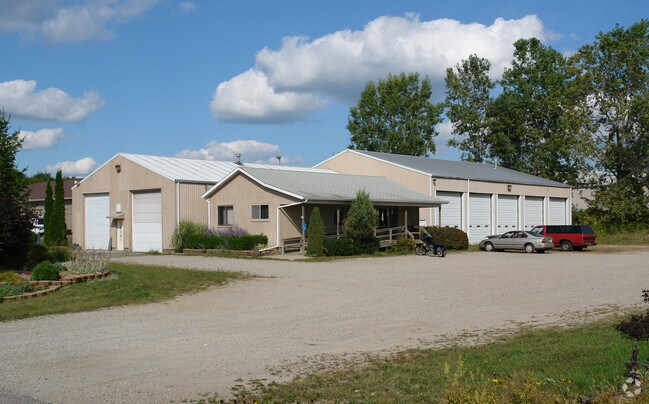
16261 Grove Rd, Lansing, MI 48906


Property Detail
16261 Grove Rd
150-140-000-006-01
W 1/2 OF LOT 6 OF DEMMER INDUSTRIAL PARK.
Warehouse
Clinton
LI
Michigan
B and X Area of moderate flood hazard, usually the area between the limits of the 100-year and 500-year floods.
6
2024
1.09 AC
2025
Outlying Clinton County
010300
West Michigan
3,888 SF
Lansing-East Lansing, MI
NEARBY LISTINGS FOR SALE OR LEASE
DEMOGRAPHICS near 16261 Grove Rd
1 mile
3 mile
5 mile
2025 Total Population
287
20,259
80,965
2030 Population
289
20,254
81,953
Pop Growth 2025-2030
+ 0.70%
(0.02%)
+ 1.22%
Average Age
42
42
41
2025 Total Households
112
8,523
35,174
HH Growth 2025-2030
+ 0.89%
(0.05%)
+ 1.31%
Median Household Inc
$121,428
$84,129
$69,654
Avg Household Size
2.50
2.30
2.20
2025 Avg HH Vehicles
2.00
2.00
2.00
Median Home Value
$279,486
$235,931
$220,095
Median Year Built
1974
1971
1970
Nearby Places
Map Layers
Map Styles
 Street
 Aerial
Layers
 Traffic
 Biking
Places
Listings with unknown addresses are not visible on the map
- Restaurants
- Banks
- Shops
- Fitness
- Groceries
PUBLIC TRANSPORTATION
AIRPORT
Capital Region International
Drive
Walk
Distance
Capital Region International
6 min
2.8 mi
Freight Ports
Port of Toledo
Drive
Walk
Distance
Port of Toledo
157 min
122.5 mi
Nearby Properties
Address
Land Use
TOTAL SIZE
Lot Size
Zoning
Address
Land Use
TOTAL SIZE
Lot Size
Zoning
4,312 SF
30.47 AC
M3
Address
Land Use
TOTAL SIZE
Lot Size
Zoning
10,440 SF
18.30 AC
LI
Address
Land Use
TOTAL SIZE
Lot Size
Zoning
73,485 SF
7.86 AC
LI
Address
Land Use
TOTAL SIZE
Lot Size
Zoning
189,157 SF
15.55 AC
NONE
Address
Land Use
TOTAL SIZE
Lot Size
Zoning
3,252 SF
10.16 AC
M3
Address
Land Use
TOTAL SIZE
Lot Size
Zoning
179,316 SF
16.68 AC
NONE
Address
Land Use
TOTAL SIZE
Lot Size
Zoning
218,000 SF
15.60 AC
LI
Address
Land Use
TOTAL SIZE
Lot Size
Zoning
189,878 SF
27.62 AC
NONE
Address
Land Use
TOTAL SIZE
Lot Size
Zoning
125,060 SF
36.10 AC
LI
Address
Land Use
TOTAL SIZE
Lot Size
Zoning
200,072 SF
23.85 AC
NONE
Address
Land Use
TOTAL SIZE
Lot Size
Zoning
215,785 SF
14 AC
NONE
Address
Land Use
TOTAL SIZE
Lot Size
Zoning
107,205 SF
15.30 AC
NONE
Address
Land Use
TOTAL SIZE
Lot Size
Zoning
6,090 SF
12.96 AC
A RESID
Address
Land Use
TOTAL SIZE
Lot Size
Zoning
149,456 SF
14.49 AC
NONE
Address
Land Use
TOTAL SIZE
Lot Size
Zoning
142,400 SF
16.75 AC
LI
Address
Land Use
TOTAL SIZE
Lot Size
Zoning
558,999 SF
41.65 AC
NONE
Address
Land Use
TOTAL SIZE
Lot Size
Zoning
149,770 SF
10.33 AC
NONE
Address
Land Use
TOTAL SIZE
Lot Size
Zoning
97,812 SF
12.16 AC
F COMME
Address
Land Use
TOTAL SIZE
Lot Size
Zoning
13,593 SF
20.95 AC
B-2
Address
Land Use
TOTAL SIZE
Lot Size
Zoning
46,418 SF
3.29 AC
NONE
Address
Land Use
TOTAL SIZE
Lot Size
Zoning
210,000 SF
14.33 AC
LI
Address
Land Use
TOTAL SIZE
Lot Size
Zoning
48,750 SF
24.53 AC
LI
Address
Land Use
TOTAL SIZE
Lot Size
Zoning
1,933 SF
7.01 AC
MIXED Z
Address
Land Use
TOTAL SIZE
Lot Size
Zoning
576 SF
26.90 AC
H LT IN
Address
Land Use
TOTAL SIZE
Lot Size
Zoning
65,633 SF
9.69 AC
NONE
Address
Land Use
TOTAL SIZE
Lot Size
Zoning
72,060 SF
41 AC
B-2
Address
Land Use
TOTAL SIZE
Lot Size
Zoning
155,287 SF
19.46 AC
NONE
Address
Land Use
TOTAL SIZE
Lot Size
Zoning
15,141 SF
16.20 AC
B-2
Address
Land Use
TOTAL SIZE
Lot Size
Zoning
87,346 SF
10.29 AC
NONE
Address
Land Use
TOTAL SIZE
Lot Size
Zoning
43,288 SF
149.50 AC
B-2
The World's #1 Commercial Real Estate Marketplace
Connect with us
© 2026 CoStar Group
The information above has been obtained from sources believed reliable. While we do not doubt its accuracy we have not verified it and make no guarantee, warranty or representation about it. It is your responsibility to independently confirm its accuracy and completeness. Any projections, opinions, assumptions, or estimates used are for example only and do not represent the current or future performance of the property. The value of this transaction to you depends on tax and other factors which should be evaluated by your tax, financial, and legal advisors. You and your advisors should conduct a careful, independent investigation of the property to determine to your satisfaction the suitability of the property for your needs.