Property Record
16261 S Boulevard Pl, Plainfield, IL 60586
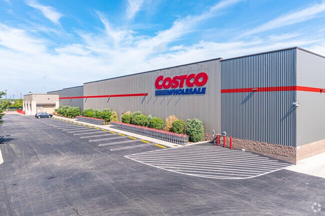
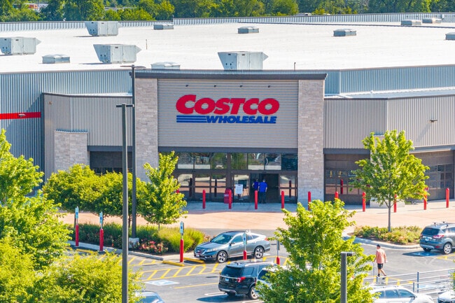
Property Detail
16261 S Boulevard Pl
Chicago
LOT 2 IN THE BOULEVARD UNIT 1, BEING A SUB OF THAT PRT OF SEC 23, T36N-R9E.
Chicago-Naperville-Elgin, IL-IN
WILL
06-03-23-201-005
Illinois
Commercialnec
2
2025
10.47 AC
2024
Joliet/Central Will
880417
NEARBY LISTINGS FOR SALE OR LEASE
-
-
-
-
-
No Photo
-
-
-
View all Plainfield listings for sale on LoopNet.com
DEMOGRAPHICS near 16261 S Boulevard Pl
1 mile
3 mile
5 mile
2025 Total Population
5,794
67,071
186,334
2030 Population
5,800
67,659
188,953
Pop Growth 2025-2030
+ 0.10%
+ 0.88%
+ 1.41%
Average Age
39
40
40
2025 Total Households
1,988
23,211
64,181
HH Growth 2025-2030
+ 0.20%
+ 1.00%
+ 1.43%
Median Household Inc
$105,627
$104,999
$100,260
Avg Household Size
2.90
2.80
2.80
2025 Avg HH Vehicles
2.00
2.00
2.00
Median Home Value
$273,815
$287,182
$291,550
Median Year Built
1997
1997
1995
Nearby Places
Map Layers
Map Styles
 Street
 Aerial
Layers
 Traffic
 Biking
Places
Listings with unknown addresses are not visible on the map
- Restaurants
- Banks
- Shops
- Fitness
- Groceries
PUBLIC TRANSPORTATION
COMMUTER RAIL
Joliet Station (Heritage Corridor Line - Northeast Illinois Regional Commuter Railroad (Metra), Rock Island District Line - Northeast Illinois Regional Commuter Railroad (Metra))
Drive
Walk
Distance
Joliet Station (Heritage Corridor Line - Northeast Illinois Regional Commuter Railroad (Metra), Rock Island District Line - Northeast Illinois Regional Commuter Railroad (Metra))
17 min
7.2 mi
Lockport Station (Heritage Corridor Line - Northeast Illinois Regional Commuter Railroad (Metra))
Drive
Walk
Distance
Lockport Station (Heritage Corridor Line - Northeast Illinois Regional Commuter Railroad (Metra))
18 min
7.5 mi
AIRPORT
Chicago Midway International
Drive
Walk
Distance
Chicago Midway International
41 min
29.3 mi
Freight Ports
Port Milwaukee
Drive
Walk
Distance
Port Milwaukee
139 min
112.4 mi
Nearby Properties
Address
Land Use
TOTAL SIZE
Lot Size
Zoning
Address
Land Use
TOTAL SIZE
Lot Size
Zoning
20.75 AC
Address
Land Use
TOTAL SIZE
Lot Size
Zoning
12.47 AC
Address
Land Use
TOTAL SIZE
Lot Size
Zoning
21.76 AC
Address
Land Use
TOTAL SIZE
Lot Size
Zoning
32.49 AC
Address
Land Use
TOTAL SIZE
Lot Size
Zoning
54.90 AC
Address
Land Use
TOTAL SIZE
Lot Size
Zoning
7.72 AC
Address
Land Use
TOTAL SIZE
Lot Size
Zoning
Address
Land Use
TOTAL SIZE
Lot Size
Zoning
18.76 AC
Address
Land Use
TOTAL SIZE
Lot Size
Zoning
20.22 AC
Address
Land Use
TOTAL SIZE
Lot Size
Zoning
Address
Land Use
TOTAL SIZE
Lot Size
Zoning
1.66 AC
Address
Land Use
TOTAL SIZE
Lot Size
Zoning
Address
Land Use
TOTAL SIZE
Lot Size
Zoning
15.45 AC
Address
Land Use
TOTAL SIZE
Lot Size
Zoning
8.46 AC
Address
Land Use
TOTAL SIZE
Lot Size
Zoning
5.75 AC
Address
Land Use
TOTAL SIZE
Lot Size
Zoning
Address
Land Use
TOTAL SIZE
Lot Size
Zoning
8.91 AC
Address
Land Use
TOTAL SIZE
Lot Size
Zoning
8.99 AC
Address
Land Use
TOTAL SIZE
Lot Size
Zoning
6.58 AC
Address
Land Use
TOTAL SIZE
Lot Size
Zoning
Address
Land Use
TOTAL SIZE
Lot Size
Zoning
0.82 AC
Address
Land Use
TOTAL SIZE
Lot Size
Zoning
3.33 AC
Address
Land Use
TOTAL SIZE
Lot Size
Zoning
11.78 AC
Address
Land Use
TOTAL SIZE
Lot Size
Zoning
12.94 AC
Address
Land Use
TOTAL SIZE
Lot Size
Zoning
2.64 AC
Address
Land Use
TOTAL SIZE
Lot Size
Zoning
13.38 AC
Address
Land Use
TOTAL SIZE
Lot Size
Zoning
8.85 AC
Address
Land Use
TOTAL SIZE
Lot Size
Zoning
8.55 AC
Address
Land Use
TOTAL SIZE
Lot Size
Zoning
The World's #1 Commercial Real Estate Marketplace
Connect with us
© 2026 CoStar Group
The information above has been obtained from sources believed reliable. While we do not doubt its accuracy we have not verified it and make no guarantee, warranty or representation about it. It is your responsibility to independently confirm its accuracy and completeness. Any projections, opinions, assumptions, or estimates used are for example only and do not represent the current or future performance of the property. The value of this transaction to you depends on tax and other factors which should be evaluated by your tax, financial, and legal advisors. You and your advisors should conduct a careful, independent investigation of the property to determine to your satisfaction the suitability of the property for your needs.