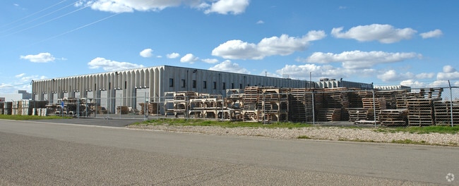
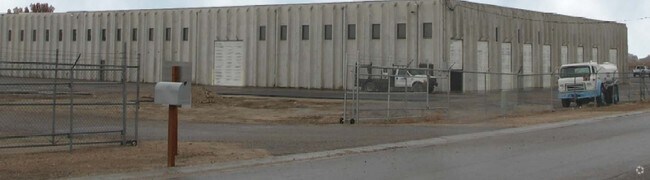
Property Record
16265 Star Rd, Nampa, ID 83687

NEARBY LISTINGS FOR SALE OR LEASE
Property Detail
16265 Star Rd
3040500000
07-3N-1W SE TX 17621 IN SE LS RD
Industrialgeneral
Canyon
X
Idaho
16027C0401F
9.64 AC
2024
Nampa
2025
Boise City/Nampa
021104
Boise City, ID
DEMOGRAPHICS near 16265 Star Rd
1 Mile
3 Mile
5 Mile
2024 Total Population
1,568
30,903
123,755
2029 Population
1,908
36,971
146,444
Pop Growth 2024-2029
+ 21.68%
+ 19.64%
+ 18.33%
Average Age
42
37
37
2024 Total Households
539
10,833
43,395
HH Growth 2024-2029
+ 21.89%
+ 19.89%
+ 18.65%
Median Household Inc
$102,174
$64,079
$71,183
Avg Household Size
2.90
2.80
2.80
2024 Avg HH Vehicles
3.00
2.00
2.00
Median Home Value
$550,395
$382,440
$378,908
Median Year Built
1992
2001
1998
Nearby Places
Map Layers
Map Styles
 Street
 Aerial
- Restaurants
- Banks
- Shops
- Fitness
- Groceries
PUBLIC TRANSPORTATION
AIRPORT
Boise Air Trml/Gowen Field
DRIVE
WALK
Distance
Boise Air Trml/Gowen Field
37 min
19.8 mi
Freight Ports
Port of Portland
DRIVE
WALK
Distance
Port of Portland
461 min
418.2 mi
SALE & LEASE HISTORY
LISTING DATE
SALE/LEASE

Sep 25, 2016
For Lease
Nearby Properties
Address
Land Use
TOTAL SIZE
Lot Size
Zoning
Address
Land Use
TOTAL SIZE
Lot Size
Zoning
61.03 AC
Address
Land Use
TOTAL SIZE
Lot Size
Zoning
52,235 SF
16.19 AC
Address
Land Use
TOTAL SIZE
Lot Size
Zoning
33.22 AC
M1
Address
Land Use
TOTAL SIZE
Lot Size
Zoning
28.03 AC
M1
Address
Land Use
TOTAL SIZE
Lot Size
Zoning
239,139 SF
38.34 AC
M1
Address
Land Use
TOTAL SIZE
Lot Size
Zoning
40.26 AC
Address
Land Use
TOTAL SIZE
Lot Size
Zoning
908 SF
48.85 AC
Address
Land Use
TOTAL SIZE
Lot Size
Zoning
2,222 SF
12.28 AC
RR
Address
Land Use
TOTAL SIZE
Lot Size
Zoning
95.54 AC
Address
Land Use
TOTAL SIZE
Lot Size
Zoning
10.44 AC
R-15
Address
Land Use
TOTAL SIZE
Lot Size
Zoning
3,308 SF
7.06 AC
Address
Land Use
TOTAL SIZE
Lot Size
Zoning
164,916 SF
8.89 AC
R-15
Address
Land Use
TOTAL SIZE
Lot Size
Zoning
262,845 SF
11.97 AC
R-15
Address
Land Use
TOTAL SIZE
Lot Size
Zoning
128,063 SF
10.78 AC
R-15
Address
Land Use
TOTAL SIZE
Lot Size
Zoning
149.04 AC
Address
Land Use
TOTAL SIZE
Lot Size
Zoning
8.34 AC
R1
Address
Land Use
TOTAL SIZE
Lot Size
Zoning
136,249 SF
16.36 AC
Address
Land Use
TOTAL SIZE
Lot Size
Zoning
1,696 SF
5.28 AC
R1
Address
Land Use
TOTAL SIZE
Lot Size
Zoning
18.39 AC
Address
Land Use
TOTAL SIZE
Lot Size
Zoning
11.74 AC
Address
Land Use
TOTAL SIZE
Lot Size
Zoning
189,415 SF
10 AC
Address
Land Use
TOTAL SIZE
Lot Size
Zoning
104,041 SF
4.36 AC
R-15
Address
Land Use
TOTAL SIZE
Lot Size
Zoning
212,196 SF
24.14 AC
Address
Land Use
TOTAL SIZE
Lot Size
Zoning
98,768 SF
13.49 AC
Address
Land Use
TOTAL SIZE
Lot Size
Zoning
55.24 AC
Address
Land Use
TOTAL SIZE
Lot Size
Zoning
16.19 AC
Address
Land Use
TOTAL SIZE
Lot Size
Zoning
95,785 SF
5.04 AC
Address
Land Use
TOTAL SIZE
Lot Size
Zoning
132,417 SF
10.53 AC
I-L
Address
Land Use
TOTAL SIZE
Lot Size
Zoning
268,905 SF
15.44 AC
C-G
Address
Land Use
TOTAL SIZE
Lot Size
Zoning
10,000 SF
8.50 AC
The World's #1 Commercial Real Estate Marketplace
Connect with us
© 2025 CoStar Group
The information above has been obtained from sources believed reliable. While we do not doubt its accuracy we have not verified it and make no guarantee, warranty or representation about it. It is your responsibility to independently confirm its accuracy and completeness. Any projections, opinions, assumptions, or estimates used are for example only and do not represent the current or future performance of the property. The value of this transaction to you depends on tax and other factors which should be evaluated by your tax, financial, and legal advisors. You and your advisors should conduct a careful, independent investigation of the property to determine to your satisfaction the suitability of the property for your needs.