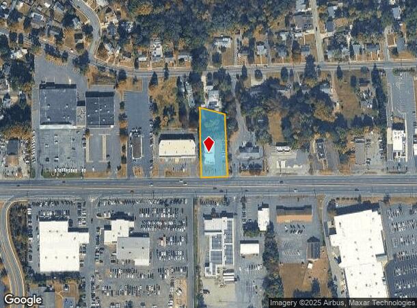
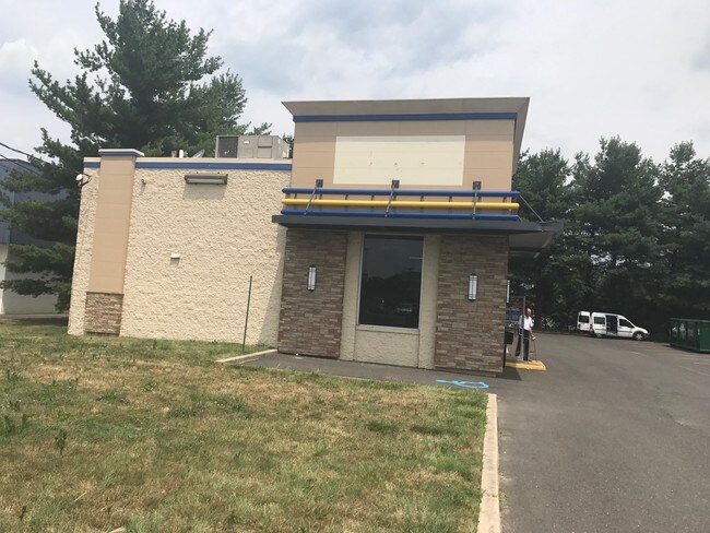
Property Record
1627 Route 38, Lumberton, NJ 08048

NEARBY LISTINGS FOR SALE OR LEASE
Property Detail
1627 Route 38
17-00018-0000-00004
Burlington
Commercialnec
New Jersey
X
4
34005C0256F
0.75 AC
2024
South Burlington County
2025
Philadelphia
703104
Philadelphia-Camden-Wilmington, PA-NJ-DE-MD
DEMOGRAPHICS near 1627 Route 38
1 Mile
3 Mile
5 Mile
2024 Total Population
11,860
39,999
70,289
2029 Population
12,226
40,898
71,683
Pop Growth 2024-2029
+ 3.09%
+ 2.25%
+ 1.98%
Average Age
39
40
41
2024 Total Households
4,452
15,081
27,281
HH Growth 2024-2029
+ 3.53%
+ 2.45%
+ 2.06%
Median Household Inc
$67,918
$92,898
$98,469
Avg Household Size
2.50
2.60
2.50
2024 Avg HH Vehicles
2.00
2.00
2.00
Median Home Value
$243,364
$298,816
$294,841
Median Year Built
1975
1981
1983
Nearby Places
Map Layers
Map Styles
 Street
 Aerial
- Restaurants
- Banks
- Shops
- Fitness
- Groceries
PUBLIC TRANSPORTATION
AIRPORT
Trenton Mercer
DRIVE
WALK
Distance
Trenton Mercer
43 min
28.7 mi
Philadelphia International
DRIVE
WALK
Distance
Philadelphia International
45 min
29.4 mi
Freight Ports
South Jersey Port
DRIVE
WALK
Distance
South Jersey Port
28 min
19.2 mi
SALE & LEASE HISTORY
LISTING DATE
SALE/LEASE

Sep 22, 2017
For Lease
Nov 29, 2017
For Lease
Nearby Properties
Address
Land Use
TOTAL SIZE
Lot Size
Zoning
Address
Land Use
TOTAL SIZE
Lot Size
Zoning
3.03 AC
OB
Address
Land Use
TOTAL SIZE
Lot Size
Zoning
100 AC
R-5
Address
Land Use
TOTAL SIZE
Lot Size
Zoning
53.05 AC
I2
Address
Land Use
TOTAL SIZE
Lot Size
Zoning
19.38 AC
R1
Address
Land Use
TOTAL SIZE
Lot Size
Zoning
478,715 SF
35.19 AC
Address
Land Use
TOTAL SIZE
Lot Size
Zoning
6.59 AC
GS
Address
Land Use
TOTAL SIZE
Lot Size
Zoning
0.52 AC
GS
Address
Land Use
TOTAL SIZE
Lot Size
Zoning
Address
Land Use
TOTAL SIZE
Lot Size
Zoning
11.82 AC
R-5
Address
Land Use
TOTAL SIZE
Lot Size
Zoning
12.31 AC
Address
Land Use
TOTAL SIZE
Lot Size
Zoning
12.90 AC
Address
Land Use
TOTAL SIZE
Lot Size
Zoning
20.52 AC
RH
Address
Land Use
TOTAL SIZE
Lot Size
Zoning
28 AC
B3
Address
Land Use
TOTAL SIZE
Lot Size
Zoning
16.79 AC
R12
Address
Land Use
TOTAL SIZE
Lot Size
Zoning
10.12 AC
Address
Land Use
TOTAL SIZE
Lot Size
Zoning
23.33 AC
B2
Address
Land Use
TOTAL SIZE
Lot Size
Zoning
Address
Land Use
TOTAL SIZE
Lot Size
Zoning
15.60 AC
RH
Address
Land Use
TOTAL SIZE
Lot Size
Zoning
4.11 AC
Address
Land Use
TOTAL SIZE
Lot Size
Zoning
15 AC
R2
Address
Land Use
TOTAL SIZE
Lot Size
Zoning
15.64 AC
I2
Address
Land Use
TOTAL SIZE
Lot Size
Zoning
24.36 AC
Address
Land Use
TOTAL SIZE
Lot Size
Zoning
Address
Land Use
TOTAL SIZE
Lot Size
Zoning
4.51 AC
PA
Address
Land Use
TOTAL SIZE
Lot Size
Zoning
19.21 AC
R1
Address
Land Use
TOTAL SIZE
Lot Size
Zoning
20 AC
R12
Address
Land Use
TOTAL SIZE
Lot Size
Zoning
3.95 AC
RED
Address
Land Use
TOTAL SIZE
Lot Size
Zoning
3.85 AC
R75
Address
Land Use
TOTAL SIZE
Lot Size
Zoning
35 AC
R2.5
Address
Land Use
TOTAL SIZE
Lot Size
Zoning
11.53 AC
RH
The World's #1 Commercial Real Estate Marketplace
Connect with us
© 2025 CoStar Group
The information above has been obtained from sources believed reliable. While we do not doubt its accuracy we have not verified it and make no guarantee, warranty or representation about it. It is your responsibility to independently confirm its accuracy and completeness. Any projections, opinions, assumptions, or estimates used are for example only and do not represent the current or future performance of the property. The value of this transaction to you depends on tax and other factors which should be evaluated by your tax, financial, and legal advisors. You and your advisors should conduct a careful, independent investigation of the property to determine to your satisfaction the suitability of the property for your needs.