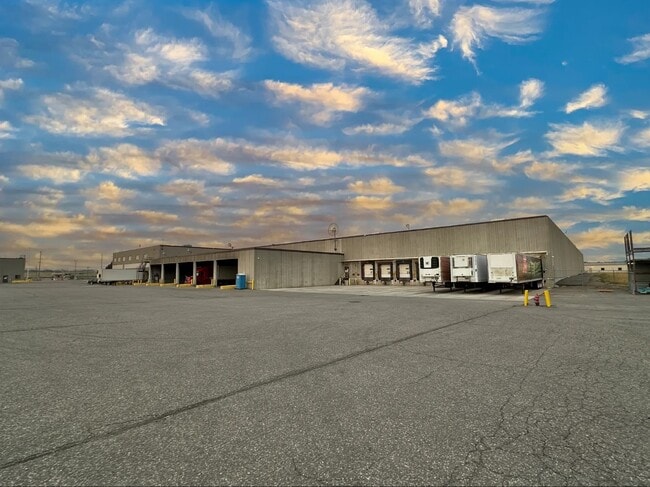
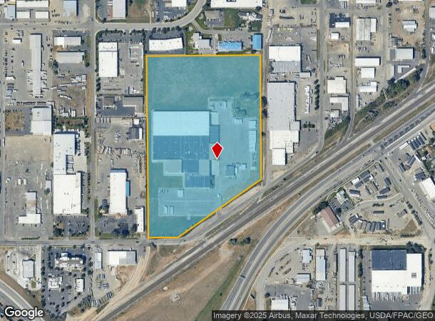
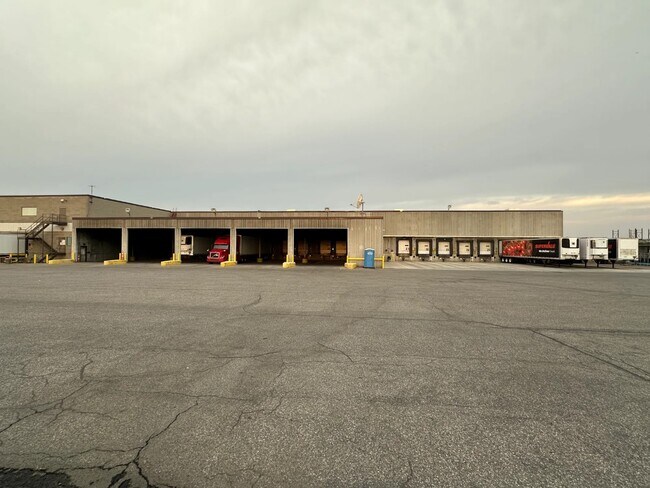
Property Record
1629 King Ave W, Billings, MT 59102

Current Lease Availabilities
NEARBY LISTINGS FOR SALE OR LEASE
Property Detail
1629 King Ave W
03-0927-07-4-05-01-0000
Cert/Survey 1613
Commercialnec
S07, T01 S, R26 E, C.O.S. 2886, PARCEL 1A, 24.592 AC (97)
X
Yellowstone
30111C1270E
Montana
2024
24.59 AC
2025
Billings
001702
Other Market Areas
253,126 SF
Billings, MT
DEMOGRAPHICS near 1629 King Ave W
1 Mile
3 Mile
5 Mile
2024 Total Population
4,123
67,526
99,905
2029 Population
4,476
73,065
108,252
Pop Growth 2024-2029
+ 8.56%
+ 8.20%
+ 8.35%
Average Age
38
40
41
2024 Total Households
1,699
29,608
42,959
HH Growth 2024-2029
+ 8.71%
+ 8.38%
+ 8.54%
Median Household Inc
$56,146
$62,801
$67,812
Avg Household Size
2.40
2.20
2.20
2024 Avg HH Vehicles
2.00
2.00
2.00
Median Home Value
$247,315
$262,690
$294,536
Median Year Built
1964
1971
1976
Nearby Places
- Restaurants
- Banks
- Shops
- Fitness
- Groceries
PUBLIC TRANSPORTATION
AIRPORT
Billings Logan International
DRIVE
WALK
Distance
Billings Logan International
26 min
9.0 mi
Freight Ports
Port of Everett
DRIVE
WALK
Distance
Port of Everett
880 min
838.8 mi
Nearby Properties
Address
Land Use
TOTAL SIZE
Lot Size
Zoning
Address
Land Use
TOTAL SIZE
Lot Size
Zoning
483,842 SF
55.14 AC
P
Address
Land Use
TOTAL SIZE
Lot Size
Zoning
295,400 SF
17 AC
Address
Land Use
TOTAL SIZE
Lot Size
Zoning
164,242 SF
33.08 AC
P
Address
Land Use
TOTAL SIZE
Lot Size
Zoning
136,588 SF
21.01 AC
CI
Address
Land Use
TOTAL SIZE
Lot Size
Zoning
259,684 SF
14.73 AC
Address
Land Use
TOTAL SIZE
Lot Size
Zoning
258,977 SF
18.05 AC
CI
Address
Land Use
TOTAL SIZE
Lot Size
Zoning
116,250 SF
9.39 AC
Address
Land Use
TOTAL SIZE
Lot Size
Zoning
76,098 SF
0.80 AC
CBD
Address
Land Use
TOTAL SIZE
Lot Size
Zoning
537,468 SF
36.83 AC
CC
Address
Land Use
TOTAL SIZE
Lot Size
Zoning
173,807 SF
11.56 AC
CI
Address
Land Use
TOTAL SIZE
Lot Size
Zoning
218,478 SF
18.19 AC
CI
Address
Land Use
TOTAL SIZE
Lot Size
Zoning
172.22 AC
Address
Land Use
TOTAL SIZE
Lot Size
Zoning
71,600 SF
0.15 AC
CBD
Address
Land Use
TOTAL SIZE
Lot Size
Zoning
177,290 SF
14.59 AC
HC
Address
Land Use
TOTAL SIZE
Lot Size
Zoning
188,907 SF
3.83 AC
CC
Address
Land Use
TOTAL SIZE
Lot Size
Zoning
151,056 SF
49.20 AC
A-1
Address
Land Use
TOTAL SIZE
Lot Size
Zoning
149,797 SF
12.95 AC
CC
Address
Land Use
TOTAL SIZE
Lot Size
Zoning
26.09 AC
Address
Land Use
TOTAL SIZE
Lot Size
Zoning
118,640 SF
12.55 AC
P
Address
Land Use
TOTAL SIZE
Lot Size
Zoning
1,200 SF
57.17 AC
P
Address
Land Use
TOTAL SIZE
Lot Size
Zoning
409,620 SF
27.42 AC
CI
Address
Land Use
TOTAL SIZE
Lot Size
Zoning
135,273 SF
3.76 AC
R-60
Address
Land Use
TOTAL SIZE
Lot Size
Zoning
141,186 SF
2.62 AC
CBD
Address
Land Use
TOTAL SIZE
Lot Size
Zoning
111,120 SF
1.91 AC
CBD
Address
Land Use
TOTAL SIZE
Lot Size
Zoning
109,485 SF
8.87 AC
R-96
Address
Land Use
TOTAL SIZE
Lot Size
Zoning
155,084 SF
13.78 AC
P
Address
Land Use
TOTAL SIZE
Lot Size
Zoning
167,744 SF
16.45 AC
CI
Address
Land Use
TOTAL SIZE
Lot Size
Zoning
20.27 AC
P
Address
Land Use
TOTAL SIZE
Lot Size
Zoning
38,313 SF
3.27 AC
Address
Land Use
TOTAL SIZE
Lot Size
Zoning
74,990 SF
0.59 AC
CBD
The World's #1 Commercial Real Estate Marketplace
Connect with us
© 2025 CoStar Group
The information above has been obtained from sources believed reliable. While we do not doubt its accuracy we have not verified it and make no guarantee, warranty or representation about it. It is your responsibility to independently confirm its accuracy and completeness. Any projections, opinions, assumptions, or estimates used are for example only and do not represent the current or future performance of the property. The value of this transaction to you depends on tax and other factors which should be evaluated by your tax, financial, and legal advisors. You and your advisors should conduct a careful, independent investigation of the property to determine to your satisfaction the suitability of the property for your needs.