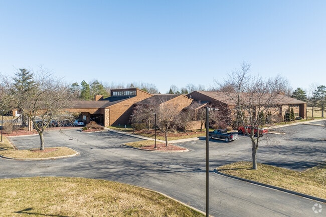
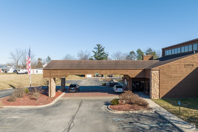
Property Record
1629 W Maumee St, Adrian, MI 49221

NEARBY LISTINGS FOR SALE OR LEASE
-
-
View all Adrian listings for sale on LoopNet.com
Property Detail
1629 W Maumee St
XA0-100-0296-02
BEG 885.72 FT E & 250 FT S OF NW COR OF E 1/2 OF SW 1/4 OF SEC 33 T6S R3E TH S 450 FT TH WLY 401.79 FT TH N 450 FT TH ELY
Commercialnec
Lenawee
X
Michigan
26091C0189D
4.15 AC
2024
Ann Arbor/Jackson
2025
Toledo
061500
Adrian, MI
25,929 SF
DEMOGRAPHICS near 1629 W Maumee St
1 Mile
3 Mile
5 Mile
2024 Total Population
4,713
26,723
34,873
2029 Population
4,699
26,466
34,515
Pop Growth 2024-2029
(0.30%)
(0.96%)
(1.03%)
Average Age
41
40
40
2024 Total Households
1,730
10,218
12,788
HH Growth 2024-2029
(0.29%)
(1.05%)
(1.10%)
Median Household Inc
$52,083
$41,550
$47,917
Avg Household Size
2.30
2.30
2.30
2024 Avg HH Vehicles
2.00
2.00
2.00
Median Home Value
$149,184
$125,067
$135,933
Median Year Built
1981
1965
1968
Nearby Places
Map Layers
Map Styles
 Street
 Aerial
- Restaurants
- Banks
- Shops
- Fitness
- Groceries
PUBLIC TRANSPORTATION
AIRPORT
Eugene F Kranz Toledo Express
DRIVE
WALK
Distance
Eugene F Kranz Toledo Express
61 min
35.8 mi
Freight Ports
Port of Toledo
DRIVE
WALK
Distance
Port of Toledo
63 min
44.2 mi
SALE & LEASE HISTORY
LISTING DATE
SALE/LEASE

May 30, 2017
For Sale
Aug 04, 2023
For Sale
Nearby Properties
Address
Land Use
TOTAL SIZE
Lot Size
Zoning
Address
Land Use
TOTAL SIZE
Lot Size
Zoning
297,470 SF
31.39 AC
I-2
Address
Land Use
TOTAL SIZE
Lot Size
Zoning
19,469 SF
27.08 AC
I-2
Address
Land Use
TOTAL SIZE
Lot Size
Zoning
21.68 AC
B-4
Address
Land Use
TOTAL SIZE
Lot Size
Zoning
122,669 SF
14.27 AC
B-4
Address
Land Use
TOTAL SIZE
Lot Size
Zoning
83,180 SF
3.14 AC
ERO
Address
Land Use
TOTAL SIZE
Lot Size
Zoning
27,436 SF
79.87 AC
CI
Address
Land Use
TOTAL SIZE
Lot Size
Zoning
119,884 SF
9.37 AC
RM-1
Address
Land Use
TOTAL SIZE
Lot Size
Zoning
101,287 SF
16.98 AC
B-4
Address
Land Use
TOTAL SIZE
Lot Size
Zoning
136,850 SF
10.37 AC
RM-1
Address
Land Use
TOTAL SIZE
Lot Size
Zoning
35,880 SF
2.45 AC
Address
Land Use
TOTAL SIZE
Lot Size
Zoning
77,162 SF
22.82 AC
CI
Address
Land Use
TOTAL SIZE
Lot Size
Zoning
53,333 SF
6.70 AC
B-4
Address
Land Use
TOTAL SIZE
Lot Size
Zoning
86,479 SF
4.79 AC
Address
Land Use
TOTAL SIZE
Lot Size
Zoning
64,385 SF
11.08 AC
CI
Address
Land Use
TOTAL SIZE
Lot Size
Zoning
33,858 SF
14.53 AC
OS-1
Address
Land Use
TOTAL SIZE
Lot Size
Zoning
49,676 SF
0.94 AC
RM-2
Address
Land Use
TOTAL SIZE
Lot Size
Zoning
29.25 AC
B-4
Address
Land Use
TOTAL SIZE
Lot Size
Zoning
42,682 SF
6.41 AC
B-2
Address
Land Use
TOTAL SIZE
Lot Size
Zoning
191,777 SF
6.15 AC
E-1
Address
Land Use
TOTAL SIZE
Lot Size
Zoning
73,636 SF
9.99 AC
RM-1
Address
Land Use
TOTAL SIZE
Lot Size
Zoning
86,971 SF
9.56 AC
RM-1
Address
Land Use
TOTAL SIZE
Lot Size
Zoning
17,751 SF
2.76 AC
B-2
Address
Land Use
TOTAL SIZE
Lot Size
Zoning
72,839 SF
7.05 AC
RM-1
Address
Land Use
TOTAL SIZE
Lot Size
Zoning
288,960 SF
20.14 AC
Address
Land Use
TOTAL SIZE
Lot Size
Zoning
5,459 SF
10.01 AC
Address
Land Use
TOTAL SIZE
Lot Size
Zoning
26,404 SF
7.12 AC
ERO
Address
Land Use
TOTAL SIZE
Lot Size
Zoning
68,520 SF
7.01 AC
RM-1
Address
Land Use
TOTAL SIZE
Lot Size
Zoning
352,875 SF
12.08 AC
I-1
Address
Land Use
TOTAL SIZE
Lot Size
Zoning
123,550 SF
29.33 AC
I-1
Address
Land Use
TOTAL SIZE
Lot Size
Zoning
3.82 AC
I-1
The World's #1 Commercial Real Estate Marketplace
Connect with us
© 2025 CoStar Group
The information above has been obtained from sources believed reliable. While we do not doubt its accuracy we have not verified it and make no guarantee, warranty or representation about it. It is your responsibility to independently confirm its accuracy and completeness. Any projections, opinions, assumptions, or estimates used are for example only and do not represent the current or future performance of the property. The value of this transaction to you depends on tax and other factors which should be evaluated by your tax, financial, and legal advisors. You and your advisors should conduct a careful, independent investigation of the property to determine to your satisfaction the suitability of the property for your needs.