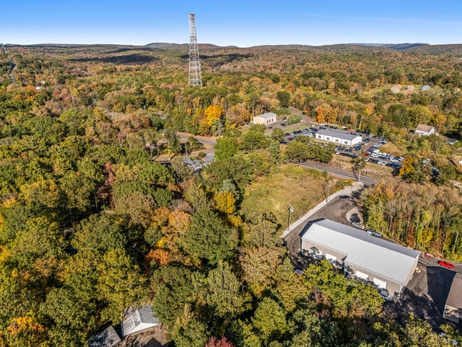
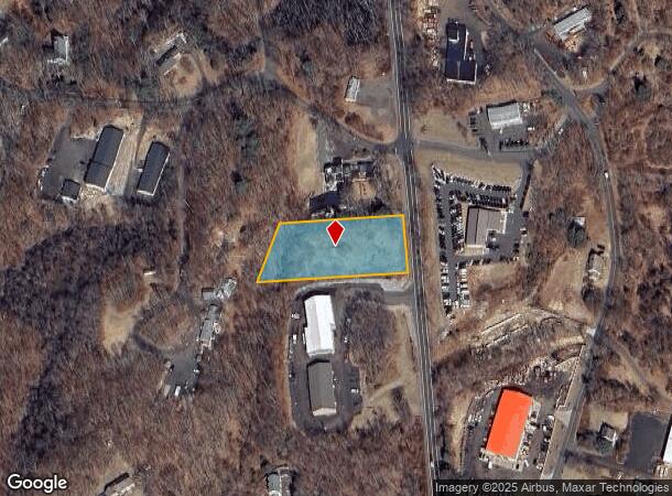
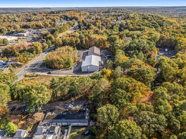
Property Record
163 Amity Rd, Bethany, CT 06524
NEARBY LISTINGS FOR SALE OR LEASE
Property Detail
163 Amity Rd
Vacantlandnec
New Haven
X
Connecticut
09009C0269H
1.25 AC
2025
Woodbridge
2025
Westchester/So Connecticut
161100
New Haven, CT
2,304 SF
BETH-000113-000000-000050
DEMOGRAPHICS near 163 Amity Rd
1 mile
3 mile
5 mile
2024 Total Population
766
10,950
69,273
2029 Population
766
10,979
69,305
Pop Growth 2024-2029
0.00%
+ 0.26%
+ 0.05%
Average Age
42
43
42
2024 Total Households
268
4,068
27,170
HH Growth 2024-2029
0.00%
+ 0.22%
0.00%
Median Household Inc
$146,874
$145,226
$92,688
Avg Household Size
2.90
2.70
2.40
2024 Avg HH Vehicles
2.00
2.00
2.00
Median Home Value
$461,979
$419,952
$285,266
Median Year Built
1994
1970
1972
Nearby Places
Map Layers
Map Styles
 Street
 Aerial
Transit
 Traffic
 Biking
Places
Listings with unknown addresses are not visible on the map
- Restaurants
- Banks
- Shops
- Fitness
- Groceries
PUBLIC TRANSPORTATION
COMMUTER RAIL
Seymour Station (New Haven Line - Metro-North Commuter Railroad Company (Metro-North))
Drive
Walk
Distance
Seymour Station (New Haven Line - Metro-North Commuter Railroad Company (Metro-North))
10 min
6.0 mi
Beacon Falls Station (New Haven Line - Metro-North Commuter Railroad Company (Metro-North))
Drive
Walk
Distance
Beacon Falls Station (New Haven Line - Metro-North Commuter Railroad Company (Metro-North))
15 min
8.4 mi
AIRPORT
Tweed/New Haven
Drive
Walk
Distance
Tweed/New Haven
26 min
13.1 mi
Freight Ports
Port of New Haven
Drive
Walk
Distance
Port of New Haven
20 min
10.9 mi
SALE & LEASE HISTORY
LISTING DATE
SALE/LEASE

Oct 12, 2025
For Sale
Mar 05, 2018
For Sale
Nearby Properties
Address
Land Use
TOTAL SIZE
Lot Size
Zoning
Address
Land Use
TOTAL SIZE
Lot Size
Zoning
101,933 SF
22.11 AC
R-18
Address
Land Use
TOTAL SIZE
Lot Size
Zoning
19 AC
B&I
Address
Land Use
TOTAL SIZE
Lot Size
Zoning
28.70 AC
R-65
Address
Land Use
TOTAL SIZE
Lot Size
Zoning
500 AC
R1
Address
Land Use
TOTAL SIZE
Lot Size
Zoning
580.20 AC
A
Address
Land Use
TOTAL SIZE
Lot Size
Zoning
50.90 AC
R-65
Address
Land Use
TOTAL SIZE
Lot Size
Zoning
102,109 SF
9.19 AC
GI-2
Address
Land Use
TOTAL SIZE
Lot Size
Zoning
93,672 SF
7.97 AC
GI-2
Address
Land Use
TOTAL SIZE
Lot Size
Zoning
73,745 SF
11.40 AC
GI-2
Address
Land Use
TOTAL SIZE
Lot Size
Zoning
8.22 AC
GI-2
Address
Land Use
TOTAL SIZE
Lot Size
Zoning
58,760 SF
9.40 AC
MF
Address
Land Use
TOTAL SIZE
Lot Size
Zoning
49,560 SF
6.90 AC
R-18
Address
Land Use
TOTAL SIZE
Lot Size
Zoning
104,950 SF
21.41 AC
GI-2
Address
Land Use
TOTAL SIZE
Lot Size
Zoning
53,191 SF
10.02 AC
GI-2
Address
Land Use
TOTAL SIZE
Lot Size
Zoning
71,286 SF
8.67 AC
GI-2
Address
Land Use
TOTAL SIZE
Lot Size
Zoning
60,652 SF
4.37 AC
R-18
Address
Land Use
TOTAL SIZE
Lot Size
Zoning
5.50 AC
MF
Address
Land Use
TOTAL SIZE
Lot Size
Zoning
8,964 SF
35.19 AC
R2
Address
Land Use
TOTAL SIZE
Lot Size
Zoning
18,387 SF
138.50 AC
B&I
Address
Land Use
TOTAL SIZE
Lot Size
Zoning
1,568 SF
11.18 AC
B&I
Address
Land Use
TOTAL SIZE
Lot Size
Zoning
56,065 SF
6.62 AC
GI-2
Address
Land Use
TOTAL SIZE
Lot Size
Zoning
60,900 SF
6.27 AC
GI-2
Address
Land Use
TOTAL SIZE
Lot Size
Zoning
2,470 SF
2.15 AC
GI-2
Address
Land Use
TOTAL SIZE
Lot Size
Zoning
435.06 AC
A
Address
Land Use
TOTAL SIZE
Lot Size
Zoning
4,429 SF
1.37 AC
R-3
Address
Land Use
TOTAL SIZE
Lot Size
Zoning
11.11 AC
R-130
Address
Land Use
TOTAL SIZE
Lot Size
Zoning
16.93 AC
A
Address
Land Use
TOTAL SIZE
Lot Size
Zoning
8,204 SF
2.28 AC
A
Address
Land Use
TOTAL SIZE
Lot Size
Zoning
3.67 AC
B&I
Address
Land Use
TOTAL SIZE
Lot Size
Zoning
198.24 AC
A
The World's #1 Commercial Real Estate Marketplace
Connect with us
© 2026 CoStar Group
The information above has been obtained from sources believed reliable. While we do not doubt its accuracy we have not verified it and make no guarantee, warranty or representation about it. It is your responsibility to independently confirm its accuracy and completeness. Any projections, opinions, assumptions, or estimates used are for example only and do not represent the current or future performance of the property. The value of this transaction to you depends on tax and other factors which should be evaluated by your tax, financial, and legal advisors. You and your advisors should conduct a careful, independent investigation of the property to determine to your satisfaction the suitability of the property for your needs.